
Sipsey River facts for kids
Quick facts for kids Sipsey River |
|
|---|---|

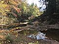
Sipsey River in the 2016 drought
|
|
| Country | United States |
| State | Alabama |
| Physical characteristics | |
| Main source | 33°54′52″N 87°41′14″W / 33.91454°N 87.68724°W |
| River mouth | 33°00′14″N 88°10′19″W / 33.00401°N 88.17197°W |
| Length | 145 mi (233 km) |
| Basin features | |
| Basin size | 789 sq mi (2,044 km2) |
The Sipsey River is a long river in west-central Alabama. It flows through areas that are often wet and swampy. The river is surrounded by special wet areas called wetlands.
Contents
About the Sipsey River
The Sipsey River is about 145 miles (233 kilometers) long. It starts near a town called Glen Allen. The river then flows into the Tombigbee River near Vienna.
Where is the Sipsey River?
The Sipsey River is part of a large natural area. This area is known as the Southeastern Coastal Plain in the United States. The land around the river is a type of forest. This forest has trees that lose their leaves in the fall. This kind of forest is called an eastern deciduous forest.
What Makes the Sipsey River Special?
The Sipsey River is unique because of its wetland habitat. Wetlands are important places for many plants and animals. They act like natural filters for water. They also provide homes for wildlife. The river's low-lying and swampy nature helps create these special environments.
Images for kids
-
The Sipsey River during a dry period in 2016.
