
Pickens County, Alabama facts for kids
Quick facts for kids
Pickens County
|
||
|---|---|---|

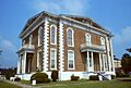
Pickens County Courthouse in Carrollton
|
||
|
||

Location within the U.S. state of Alabama
|
||
 Alabama's location within the U.S. |
||
| Country | ||
| State | ||
| Founded | December 20, 1820 | |
| Named for | Andrew Pickens | |
| Seat | Carrollton | |
| Largest city | Aliceville | |
| Area | ||
| • Total | 890 sq mi (2,300 km2) | |
| • Land | 881 sq mi (2,280 km2) | |
| • Water | 8.7 sq mi (23 km2) 1.0% | |
| Population
(2020)
|
||
| • Total | 19,123 | |
| • Estimate
(2023)
|
18,688 |
|
| • Density | 21.49/sq mi (8.30/km2) | |
| Time zone | UTC−6 (Central) | |
| • Summer (DST) | UTC−5 (CDT) | |
| Congressional district | 7th | |
|
||
Pickens County is a county located in the western part of Alabama, a state in the United States. It sits right on the border with Mississippi. In 2020, about 19,123 people lived here. The main town and county seat is Carrollton, which is in the middle of the county.
Pickens County used to be a "dry county," meaning there were rules against selling alcohol. However, the towns of Carrollton and Aliceville voted in 2011 and 2012 to allow alcohol sales. Pickens County is also part of the larger Tuscaloosa Metropolitan Area.
Contents
A Look Back at Pickens County's History
Pickens County was created on December 20, 1820. It was named after General Andrew Pickens, a hero from the American Revolutionary War. The county seat first started in Pickensville. But in 1830, it moved to Carrollton.
The first courthouse in Carrollton was burned down on April 5, 1865. This happened during the American Civil War by soldiers from the Union Army. The county was known for its large cotton farms. Many African-American people were forced to work on these farms as slaves.
Another courthouse was destroyed by fire on November 16, 1876. This happened near the end of a time called the Reconstruction era.
Recent Times: From Tornadoes to Growth
On April 8, 1998, a very strong tornado hit Pickens County. This storm injured two people and damaged many homes. It traveled for 17 miles (27 km). The same storm later caused an even stronger tornado in nearby Jefferson County.
For many years, from 2000 to 2013, the number of people living in Pickens County was going down. But then, from July 2013 to July 2014, the population grew by 5.1%! This made it one of the fastest-growing counties in Alabama. This growth happened because a new federal prison for women, the Federal Correctional Institution, Aliceville, was built there.
Where is Pickens County?
Pickens County covers a total area of about 890 square miles (2,300 square kilometers). Most of this area, about 881 square miles, is land. The rest, about 8.7 square miles, is water.
The county is located between Tuscaloosa County and the state line of Alabama and Mississippi.
Neighbors of Pickens County
Pickens County shares its borders with several other counties:
- Lamar County (to the north)
- Fayette County (to the northeast)
- Tuscaloosa County (to the east)
- Greene County (to the southeast)
- Sumter County (to the south)
- Noxubee County, Mississippi (to the southwest)
- Lowndes County, Mississippi (to the west)
Getting Around Pickens County
You can travel through Pickens County using several major roads and railways.
Major Highways
 U.S. Highway 82
 State Route 14
 State Route 17
 State Route 32
 State Route 86
 State Route 159
Rail
- Alabama and Gulf Coast Railway
- Alabama Southern Railroad
People of Pickens County
| Historical population | |||
|---|---|---|---|
| Census | Pop. | %± | |
| 1830 | 6,622 | — | |
| 1840 | 17,118 | 158.5% | |
| 1850 | 21,512 | 25.7% | |
| 1860 | 22,316 | 3.7% | |
| 1870 | 17,690 | −20.7% | |
| 1880 | 21,479 | 21.4% | |
| 1890 | 22,470 | 4.6% | |
| 1900 | 24,402 | 8.6% | |
| 1910 | 25,055 | 2.7% | |
| 1920 | 25,353 | 1.2% | |
| 1930 | 24,902 | −1.8% | |
| 1940 | 27,671 | 11.1% | |
| 1950 | 24,349 | −12.0% | |
| 1960 | 21,882 | −10.1% | |
| 1970 | 20,326 | −7.1% | |
| 1980 | 21,481 | 5.7% | |
| 1990 | 20,699 | −3.6% | |
| 2000 | 20,949 | 1.2% | |
| 2010 | 19,746 | −5.7% | |
| 2020 | 19,123 | −3.2% | |
| 2023 (est.) | 18,688 | −5.4% | |
| U.S. Decennial Census 1790–1960 1900–1990 1990–2000 2010–2020 |
|||
2020 Census Information
| Race | Num. | Perc. |
|---|---|---|
| White (non-Hispanic) | 10,066 | 52.64% |
| Black or African American (non-Hispanic) | 7,448 | 38.95% |
| Native American | 23 | 0.12% |
| Asian | 78 | 0.41% |
| Other/Mixed | 455 | 2.38% |
| Hispanic or Latino | 1,053 | 5.51% |
According to the 2020 United States census, there were 19,123 people living in Pickens County. There were 7,637 households and 5,074 families.
2010 Census Information
In the 2010 United States census, there were 19,746 people in the county.
- About 56.3% were White.
- About 41.6% were Black or African American.
- About 0.2% were Asian.
- About 0.1% were Native American.
- About 0.6% were of some other race.
- About 1.2% were of two or more races.
- About 1.6% of the people were Hispanic or Latino (this group can be of any race).
Towns and Communities
Pickens County has several towns and communities.
Cities
Towns
- Carrollton (This is the county seat)
- Ethelsville
- Gordo
- McMullen
- Memphis
- Pickensville
Census-Designated Places
Unincorporated Communities
These are smaller communities that are not officially organized as cities or towns.
Images for kids
-
Pickens County Courthouse in Carrollton
See also
 In Spanish: Condado de Pickens (Alabama) para niños
