McKinley, Alabama facts for kids
Quick facts for kids
McKinley, Alabama
|
|
|---|---|

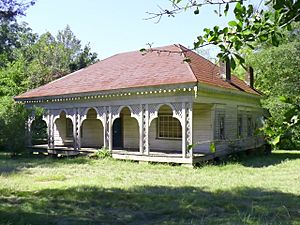
A house at McKinley in 2008
|
|
| Country | United States |
| State | Alabama |
| County | Marengo |
| Elevation | 338 ft (103 m) |
| Time zone | UTC-6 (Central (CST)) |
| • Summer (DST) | UTC-5 (CDT) |
| ZIP code |
36783
|
| Area code(s) | 334 |
McKinley is a small, unincorporated community in Marengo County, Alabama, in the United States. An "unincorporated community" means it's a place where people live, but it doesn't have its own local government like a city or town. McKinley once had its own post office, but it's no longer there. While it was a busy place in its early days, it has become very quiet over time.
History of McKinley
McKinley was first known as New Ruin. People started settling there in 1815. The community officially became a town in 1848. On December 7, 1848, a masonic lodge called Phister Lodge #90 received its official permission to operate there. A masonic lodge is a local branch of a social and charitable organization.
The community's name was changed to McKinley in 1849. This was done to honor John McKinley. He was an important person who served as a U.S. Senator and later as an Associate Justice of the United States Supreme Court. These are high-level government positions in the United States.
Growth and Development
McKinley grew very quickly in the 1850s. It became the second-largest town in Marengo County, right after Demopolis. About thirty large plantations were located around the settlement. Plantations were large farms that often grew crops like cotton.
By 1860, McKinley was a busy place. It had churches for Methodists, Baptists, and Presbyterians. There were also two schools for children to learn. The town had several general stores where people could buy goods. There was a brick drug store, places to keep and rent horses called livery stables, and a two-story shop for repairing carriages.
Other businesses included a shop for saddles and harnesses, a hotel, and three shoe shops. An undertaker helped with funerals. There was also a tanning yard for making leather, a brickyard for making bricks, and a grist mill for grinding grain.
Decline of the Town
In 1860, a big fire destroyed almost everything on the east side of Main Street. Only the hotel was saved. Then, another fire in 1869 burned down nearly the entire town.
McKinley never fully recovered from these two fires. The American Civil War also had a big impact on the area. Changes in farming methods also contributed to the town's decline. Today, only the Baptist church and a few homes are left in McKinley.
Geography of McKinley
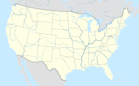
McKinley is located at coordinates 32°17′55″N 87°32′25″W / 32.298474°N 87.54028°W. Its elevation is about 338 feet (which is about 103 meters) above sea level.
 | Leon Lynch |
 | Milton P. Webster |
 | Ferdinand Smith |


