Monroe County, Mississippi facts for kids
Quick facts for kids
Monroe County
|
|
|---|---|

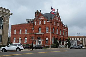
Former Monroe County Courthouse in Aberdeen.
|
|

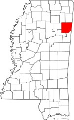
Location within the U.S. state of Mississippi
|
|
 Mississippi's location within the U.S. |
|
| Country | |
| State | |
| Founded | 1821 |
| Named for | James Monroe |
| Seat | Aberdeen |
| Largest city | Amory |
| Area | |
| • Total | 772 sq mi (2,000 km2) |
| • Land | 765 sq mi (1,980 km2) |
| • Water | 7.0 sq mi (18 km2) 0.9% |
| Population
(2020)
|
|
| • Total | 34,180 |
| • Estimate
(2023)
|
33,609 |
| • Density | 44.27/sq mi (17.095/km2) |
| Time zone | UTC−6 (Central) |
| • Summer (DST) | UTC−5 (CDT) |
| Congressional district | 1st |
Monroe County is a county in the state of Mississippi. It is located on the northeast border of Mississippi, right next to Alabama. In 2020, about 34,180 people lived here. The main town, or county seat, is Aberdeen.
Contents
History
Monroe County is named after James Monroe. He was the fifth President of the United States. A part of the county, east of the Tombigbee River, used to be part of the Alabama Territory. This area belonged to Marion County, Alabama. In 1821, new border lines were drawn. This made that part of the land become part of Mississippi.
Geography
According to the U.S. Census Bureau, Monroe County covers about 772 square miles. Most of this area, about 765 square miles, is land. The rest, about 7 square miles (0.9%), is water.
In 1922, a local report described the county's soil. It mentioned "Black Lands" with "black lime" soil. This soil is very rich in important plant nutrients like potassium and phosphorus. It comes from a rock formation called Selma chalk.
Flora
Sweet clover is a wild plant that grows naturally in Monroe County. It acts as a ground cover.
Major Roads
 U.S. Highway 45
 U.S. Highway 278
 Mississippi Highway 6
 Mississippi Highway 8
 Mississippi Highway 25
 Mississippi Highway 145
Neighboring Counties
Monroe County shares borders with several other counties:
- Lowndes County (to the south)
- Clay County (to the southwest)
- Chickasaw County (to the west)
- Lee County (to the northwest)
- Itawamba County (to the north)
- Lamar County, Alabama (to the east)
- Marion County, Alabama (to the northeast)
Population Information
| Historical population | |||
|---|---|---|---|
| Census | Pop. | %± | |
| 1820 | 2,721 | — | |
| 1830 | 3,861 | 41.9% | |
| 1840 | 9,250 | 139.6% | |
| 1850 | 21,172 | 128.9% | |
| 1860 | 21,283 | 0.5% | |
| 1870 | 22,631 | 6.3% | |
| 1880 | 28,553 | 26.2% | |
| 1890 | 30,730 | 7.6% | |
| 1900 | 31,216 | 1.6% | |
| 1910 | 35,178 | 12.7% | |
| 1920 | 32,613 | −7.3% | |
| 1930 | 36,141 | 10.8% | |
| 1940 | 37,648 | 4.2% | |
| 1950 | 36,543 | −2.9% | |
| 1960 | 33,953 | −7.1% | |
| 1970 | 34,043 | 0.3% | |
| 1980 | 36,404 | 6.9% | |
| 1990 | 36,582 | 0.5% | |
| 2000 | 38,014 | 3.9% | |
| 2010 | 36,989 | −2.7% | |
| 2020 | 34,180 | −7.6% | |
| 2023 (est.) | 33,609 | −9.1% | |
| U.S. Decennial Census 1790-1960 1900-1990 1990-2000 2010–2020 |
|||
2020 Census Details
| Race | Number of People | Percentage |
|---|---|---|
| White | 22,487 | 65.79% |
| Black or African American | 10,311 | 30.17% |
| Native American | 50 | 0.15% |
| Asian | 67 | 0.2% |
| Pacific Islander | 3 | 0.01% |
| Other/Mixed | 789 | 2.31% |
| Hispanic or Latino | 473 | 1.38% |
In 2020, there were 34,180 people living in Monroe County. These people lived in 13,966 households. There were also 9,122 families living in the county.
Economy
In 1922, Monroe County had the largest creamery and the largest hog-feeding plant in the Southern United States. At that time, corn was the most important grain crop grown in the county. Farmers often planted corn after growing and harvesting clover or oats. Oat crops usually produced 40 to 60 bushels per acre. Other crops grown for food or animal feed included wheat, rye, barley, rape, cotton, and Japan clover. Monroe County also had the most land used for growing alfalfa. It exported more alfalfa hay than any other county in Mississippi.
As of 2021, a company called US Silica operates a bentonite mine. This mine is located a few miles south of Aberdeen, near a community called Darracott. Bentonite is a type of clay. It is dug up there and then processed into chemicals for oil and gas, and also into animal feed.
Communities
Monroe County has several cities, towns, and other communities.
Cities
- Aberdeen (This is the county seat)
- Amory
- Nettleton (Part of this city is also in Lee County)
Towns
Village
Census-Designated Places
Other Unincorporated Communities
Ghost Towns
These are towns that no longer exist or are mostly abandoned:
See also
- In Spanish: Condado de Monroe (Misisipi) for kids
 | Roy Wilkins |
 | John Lewis |
 | Linda Carol Brown |

