Lee County, Mississippi facts for kids
Quick facts for kids
Lee County
|
|
|---|---|
| County of Lee | |

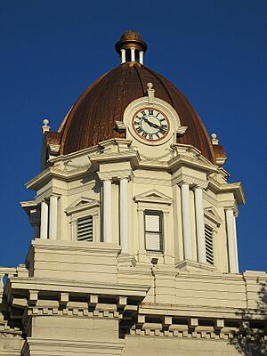
Clock tower of the Lee County Courthouse
|
|

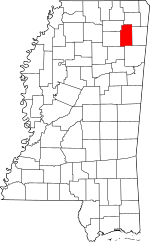
Location within the U.S. state of Mississippi
|
|
 Mississippi's location within the U.S. |
|
| Country | |
| State | |
| Founded | October 26, 1866 |
| Named for | Gen. Robert E. Lee |
| Seat | Tupelo |
| Largest city | Tupelo |
| Area | |
| • Total | 453 sq mi (1,170 km2) |
| • Land | 450 sq mi (1,200 km2) |
| • Water | 3.2 sq mi (8 km2) 0.7% |
| Population
(2020)
|
|
| • Total | 83,343 |
| • Density | 183.98/sq mi (71.04/km2) |
| Time zone | UTC−6 (Central) |
| • Summer (DST) | UTC−5 (CDT) |
| ZIP Codes |
38801, 38804, 38824, 38826, 38828, 38843, 38849, 38857, 38858, 38860, 38862, 38866, 38868, 38879
|
| Area code | 662 |
| Congressional district | 1st |
Lee County is a county located in the state of Mississippi in the United States. In 2020, about 83,343 people lived there. The main city and county seat is Tupelo. Lee County is part of the larger Tupelo area, which includes nearby towns.
Contents
History of Lee County
Lee County was created on October 26, 1866. It was named after General Robert E. Lee, a famous general from the American Civil War.
The county was formed from parts of Itawamba County and Pontotoc County. This means many early settlers of Lee County were first recorded in those older counties.
Geography of Lee County
Lee County covers a total area of about 453 square miles (1,173 square kilometers). Most of this area, about 450 square miles (1,165 square kilometers), is land. The rest, about 3.2 square miles (8.3 square kilometers), is water.
Main Roads and Highways
Several important roads pass through Lee County, making it easy to travel. These include:
 Interstate 22
 U.S. Highway 45
 U.S. Highway 78
 U.S. Route 278
 Natchez Trace Parkway
 Mississippi Highway 6
Neighboring Counties
Lee County shares borders with six other counties:
- Prentiss County (north)
- Itawamba County (east)
- Monroe County (southeast)
- Chickasaw County (southwest)
- Pontotoc County (west)
- Union County (northwest)
Protected Natural Areas
Lee County is home to parts of important national sites:
- Brices Cross Roads National Battlefield Site
- Natchez Trace Parkway (part of this historic road)
- Tupelo National Battlefield
Population and People
| Historical population | |||
|---|---|---|---|
| Census | Pop. | %± | |
| 1870 | 15,955 | — | |
| 1880 | 20,470 | 28.3% | |
| 1890 | 20,040 | −2.1% | |
| 1900 | 21,956 | 9.6% | |
| 1910 | 28,894 | 31.6% | |
| 1920 | 29,618 | 2.5% | |
| 1930 | 35,313 | 19.2% | |
| 1940 | 38,838 | 10.0% | |
| 1950 | 38,237 | −1.5% | |
| 1960 | 40,589 | 6.2% | |
| 1970 | 46,148 | 13.7% | |
| 1980 | 57,061 | 23.6% | |
| 1990 | 65,581 | 14.9% | |
| 2000 | 75,755 | 15.5% | |
| 2010 | 82,910 | 9.4% | |
| 2020 | 83,343 | 0.5% | |
| 2023 (est.) | 82,799 | −0.1% | |
| U.S. Decennial Census 1790-1960 1900-1990 1990-2000 2010-2013 2018 |
|||
As of the 2020 United States Census, there were 83,343 people living in Lee County. There were 30,378 households and 21,437 families.
Population by Race (2020)
The table below shows the different racial groups living in Lee County in 2020.
| Race | Number of People | Percentage |
|---|---|---|
| White | 52,854 | 63.42% |
| Black or African American | 24,131 | 28.95% |
| Native American | 94 | 0.11% |
| Asian | 920 | 1.1% |
| Pacific Islander | 25 | 0.03% |
| Other/Mixed | 2,491 | 2.99% |
| Hispanic or Latino | 2,828 | 3.39% |
Communities in Lee County
Lee County has several cities, towns, and smaller communities.
Cities
- Baldwyn (partly in Prentiss County)
- Saltillo
- Tupelo (the county seat)
- Verona
Towns
- Guntown
- Nettleton (partly in Monroe County)
- Plantersville
- Shannon
- Sherman (partly in Pontotoc County and Union County)
Census-Designated Places
Unincorporated Communities
These are smaller areas without their own local government.
Education in Lee County
Students in Lee County attend schools managed by several different school districts:
- Baldwyn School District
- Lee County School District
- Nettleton School District
- Tupelo Public School District
See also
 In Spanish: Condado de Lee (Misisipi) para niños
 | William M. Jackson |
 | Juan E. Gilbert |
 | Neil deGrasse Tyson |


