
Prentiss County, Mississippi facts for kids
Quick facts for kids
Prentiss County
|
|
|---|---|
| County of Prentiss | |

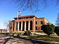
Prentiss County courthouse
|
|

Location within the U.S. state of Mississippi
|
|
 Mississippi's location within the U.S. |
|
| Country | |
| State | |
| Founded | April 15, 1870 |
| Named for | Seargent Smith Prentiss |
| Seat | Booneville |
| Largest city | Booneville |
| Area | |
| • Total | 418 sq mi (1,080 km2) |
| • Land | 415 sq mi (1,070 km2) |
| • Water | 3.2 sq mi (8 km2) 0.8% |
| Population
(2020)
|
|
| • Total | 25,008 |
| • Estimate
(2023)
|
25,135 |
| • Density | 59.83/sq mi (23.100/km2) |
| Time zone | UTC−6 (Central) |
| • Summer (DST) | UTC−5 (CDT) |
| Congressional district | 1st |
Prentiss County is a special area in the state of Mississippi, USA. It's called a county. In 2020, about 25,008 people lived here. The main town, or county seat, where the county government is located, is Booneville. The county was named after Seargent Smith Prentiss. He was a famous speaker and a US Congressman from Natchez.
Contents
Geography
Prentiss County covers a total area of about 418 square miles. Most of this area, about 415 square miles, is land. The rest, about 3.2 square miles, is water.
Major Roads
You can find several important roads in Prentiss County:
 U.S. Highway 45
 Mississippi Highway 4
 Mississippi Highway 30
 Mississippi Highway 145
Neighboring Counties
Prentiss County shares its borders with several other counties:
- Alcorn County (to the north)
- Tishomingo County (to the east)
- Itawamba County (to the southeast)
- Lee County (to the southwest)
- Union County (to the west)
- Tippah County (to the northwest)
Protected Natural Areas
Part of the Natchez Trace Parkway runs through Prentiss County. This is a special area protected for its history and nature.
People and Population
| Historical population | |||
|---|---|---|---|
| Census | Pop. | %± | |
| 1870 | 9,348 | — | |
| 1880 | 12,158 | 30.1% | |
| 1890 | 13,679 | 12.5% | |
| 1900 | 15,788 | 15.4% | |
| 1910 | 16,931 | 7.2% | |
| 1920 | 17,606 | 4.0% | |
| 1930 | 19,265 | 9.4% | |
| 1940 | 20,921 | 8.6% | |
| 1950 | 19,810 | −5.3% | |
| 1960 | 17,949 | −9.4% | |
| 1970 | 20,133 | 12.2% | |
| 1980 | 24,025 | 19.3% | |
| 1990 | 23,278 | −3.1% | |
| 2000 | 25,556 | 9.8% | |
| 2010 | 25,276 | −1.1% | |
| 2020 | 25,008 | −1.1% | |
| 2023 (est.) | 25,135 | −0.6% | |
| U.S. Decennial Census 1790-1960 1900-1990 1990-2000 2010-2013 |
|||
The population of Prentiss County has changed over the years. The chart above shows how many people have lived here since 1870.
Population in 2020
In 2020, the census counted 25,008 people living in Prentiss County. These people lived in 9,145 households, which are like family units or groups living together. There were also 6,092 families.
The table below shows the different groups of people living in Prentiss County in 2020:
| Group | Number | Percentage |
|---|---|---|
| White | 20,166 | 80.64% |
| Black or African American | 3,547 | 14.18% |
| Native American | 62 | 0.25% |
| Asian | 85 | 0.34% |
| Pacific Islander | 5 | 0.02% |
| Other/Mixed | 738 | 2.95% |
| Hispanic or Latino | 405 | 1.62% |
Communities
Prentiss County has several towns and communities where people live.
Cities
- Baldwyn (part of this city is also in Lee County)
- Booneville (This is the county seat, where the main county offices are.)
Towns
Census-Designated Places
These are areas that are like towns but are not officially incorporated as cities or towns.
Small Communities
These are smaller, unincorporated places in the county:
Education
Students in Prentiss County attend schools in different school districts:
- Baldwyn School District
- Booneville School District
- Prentiss County School District
For students who want to continue their education after high school, Northeast Mississippi Community College is located in Prentiss County.
Images for kids
-
Prentiss County courthouse
See also
 In Spanish: Condado de Prentiss (Misisipi) para niños
