Marietta, Mississippi facts for kids
Quick facts for kids
Marietta, Mississippi
|
|
|---|---|

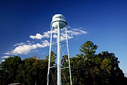
Water tower in Marietta
|
|

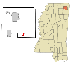
Location of Marietta, Mississippi
|
|
| Country | United States |
| State | Mississippi |
| County | Prentiss |
| Area | |
| • Total | 1.78 sq mi (4.61 km2) |
| • Land | 1.78 sq mi (4.61 km2) |
| • Water | 0.00 sq mi (0.00 km2) |
| Elevation | 345 ft (105 m) |
| Population
(2020)
|
|
| • Total | 198 |
| • Density | 111.24/sq mi (42.94/km2) |
| Time zone | UTC-6 (Central (CST)) |
| • Summer (DST) | UTC-5 (CDT) |
| ZIP code |
38856
|
| Area code(s) | 662 |
| FIPS code | 28-45120 |
| GNIS feature ID | 2406096 |
Marietta is a small town located in Prentiss County, Mississippi, in the United States. In 2020, about 198 people lived there.
Contents
Where is Marietta Located?
Marietta is found where two roads meet: Mississippi Highway 366 and Mississippi Highway 371. It is southeast of Booneville and northwest of Fulton. The famous Natchez Trace Parkway also runs just south of the town.
The United States Census Bureau says that Marietta covers an area of about 1.8 square miles (4.6 square kilometers). All of this area is land.
How Many People Live in Marietta?
The number of people living in Marietta has changed over the years. Here's a quick look at the population from different census counts:
| Historical population | |||
|---|---|---|---|
| Census | Pop. | %± | |
| 1880 | 63 | — | |
| 1910 | 146 | — | |
| 1970 | 204 | — | |
| 1980 | 298 | 46.1% | |
| 1990 | 287 | −3.7% | |
| 2000 | 248 | −13.6% | |
| 2010 | 256 | 3.2% | |
| 2020 | 198 | −22.7% | |
| U.S. Decennial Census | |||
In 2000, there were 248 people living in Marietta. Most of the people living in the town were White (98.79%). A small number were African American (1.21%).
The average age of people in Marietta in 2000 was 40 years old. About 21.8% of the population was under 18 years old.
Schools in Marietta
Students in Marietta attend schools that are part of the Prentiss County School District.
Famous People from Marietta
- Ellen Stratton, who is a model, is from Marietta.
See also
 In Spanish: Marietta (Misisipi) para niños
 | Selma Burke |
 | Pauline Powell Burns |
 | Frederick J. Brown |
 | Robert Blackburn |


