Tishomingo County, Mississippi facts for kids
Quick facts for kids
Tishomingo County
|
|
|---|---|
| County of Tishomingo | |

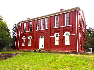
Tishomingo County Courthouse
|
|

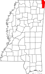
Location within the U.S. state of Mississippi
|
|
 Mississippi's location within the U.S. |
|
| Country | |
| State | |
| Founded | February 9, 1836 |
| Named for | Tishomingo |
| Seat | Iuka |
| Largest city | Iuka |
| Area | |
| • Total | 445 sq mi (1,150 km2) |
| • Land | 424 sq mi (1,100 km2) |
| • Water | 20 sq mi (50 km2) 4.6% |
| Population
(2020)
|
|
| • Total | 18,850 |
| • Estimate
(2023)
|
18,507 |
| • Density | 42.36/sq mi (16.355/km2) |
| Time zone | UTC−6 (Central) |
| • Summer (DST) | UTC−5 (CDT) |
| Congressional district | 1st |
Tishomingo County is a special area in the northeastern part of Mississippi, a state in the United States. It is called a county. In 2020, about 18,850 people lived here. The main town, where the county government is located, is Iuka.
Contents
History of Tishomingo County
Tishomingo County was created on February 9, 1836. It was formed from lands that once belonged to the Chickasaw people. The Chickasaw were a Native American tribe. They had to move from their homes to new lands in what is now Oklahoma. This was part of a big move of Native American tribes.
The first main town for Tishomingo County was Jacinto. Its old courthouse building is very important. It is listed in the National Register of Historic Places. This means it is a special historical site.
Some parts of Tishomingo County were battlegrounds during the American Civil War. The famous Battle of Shiloh took place partly in this area.
In 1870, Tishomingo County was divided into three smaller counties. These were Alcorn, Prentiss, and the new Tishomingo County. After this, the main town for Tishomingo County moved to Iuka.
Geography and Nature

Tishomingo County covers about 445 square miles. Most of this area is land, about 424 square miles. The rest, about 20 square miles, is water.
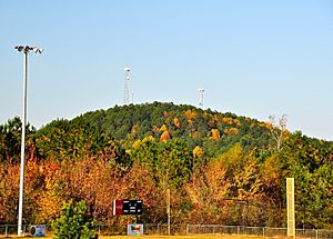
The highest natural point in the state of Mississippi is here. It is called Woodall Mountain and is about 806 feet tall. Tishomingo County is also special because it is the only county in Mississippi with natural limestone rocks showing on the surface.
Neighboring Counties
Tishomingo County shares its borders with several other counties:
- Hardin County, Tennessee (to the north)
- Lauderdale County, Alabama (to the northeast)
- Colbert County, Alabama (to the east)
- Franklin County, Alabama (to the southeast)
- Itawamba County (to the south)
- Prentiss County (to the southwest)
- Alcorn County (to the northwest)
Main Roads in the County
Many important roads run through Tishomingo County. These roads help people travel and connect different towns.
- U.S. Route 72
- Mississippi Highway 4
- Mississippi Highway 25
- Mississippi Highway 30
- Mississippi Highway 172
- Mississippi Highway 350
- Mississippi Highway 364
- Mississippi Highway 365
- Mississippi Highway 366
- Mississippi Highway 760
- Natchez Trace Parkway
Protected Natural Areas
A part of the Natchez Trace Parkway is located in Tishomingo County. This is a special road and area that protects history and nature.
People and Population
| Historical population | |||
|---|---|---|---|
| Census | Pop. | %± | |
| 1840 | 6,681 | — | |
| 1850 | 15,490 | 131.9% | |
| 1860 | 24,149 | 55.9% | |
| 1870 | 7,350 | −69.6% | |
| 1880 | 8,774 | 19.4% | |
| 1890 | 9,302 | 6.0% | |
| 1900 | 10,124 | 8.8% | |
| 1910 | 13,067 | 29.1% | |
| 1920 | 15,091 | 15.5% | |
| 1930 | 16,411 | 8.7% | |
| 1940 | 16,974 | 3.4% | |
| 1950 | 15,544 | −8.4% | |
| 1960 | 13,889 | −10.6% | |
| 1970 | 14,940 | 7.6% | |
| 1980 | 18,434 | 23.4% | |
| 1990 | 17,683 | −4.1% | |
| 2000 | 19,163 | 8.4% | |
| 2010 | 19,593 | 2.2% | |
| 2020 | 18,850 | −3.8% | |
| 2023 (est.) | 18,507 | −5.5% | |
| U.S. Decennial Census 1790-1960 1900-1990 1990-2000 2010-2013 |
|||
In 2020, there were 18,850 people living in Tishomingo County. These people lived in 7,635 homes, and 5,035 of these were families.
Most people in Tishomingo County are White. There are also smaller groups of Black or African American, Native American, and Asian people. Some people are of two or more races. About 2.85% of the people are Hispanic or Latino.
Fun Things to Do
Tishomingo County offers many outdoor activities and places to visit.
- Tishomingo State Park is a beautiful park in the foothills of the Appalachian Mountains. You can go canoeing, rock climbing, fishing, and hiking here. The park was built in the 1930s by a group called the Civilian Conservation Corps. Many of the old buildings are still there. The park is named after Tishomingo, an important leader of the Chickasaw nation.
- J.P. Coleman State Park is another state park located near Iuka. It is right next to the Tennessee River and Pickwick Lake. This park is named after James P. Coleman, who used to be the governor of Mississippi. Here, you can enjoy sailing, swimming, camping, hiking, skiing, and fishing for smallmouth bass.
- Bay Springs Lake is a large lake that is part of the Tennessee-Tombigbee Waterway. It was created by a dam called the Jamie Whitten Lock and Dam. The lake is about nine miles long and is a great spot for water activities.
- The Tennessee–Tombigbee Waterway is a huge man-made waterway. It is about 234 miles long. This waterway connects the Tennessee River and the Tombigbee River. It starts at Pickwick Lake and flows south through Mississippi and Alabama. It helps boats travel between these two major rivers.
Towns and Communities
Tishomingo County has several towns and communities where people live.
City
- Iuka (This is the main town and the county seat.)
Towns
Villages
Census-designated place
Unincorporated communities
These are smaller communities that are not officially organized as cities or towns.
Ghost town
- Holcut (This was once a town, but now it is abandoned.)
Education in Tishomingo County
All the public schools in the county are part of the Tishomingo County Schools system. For students who want to continue their education after high school, Northeast Mississippi Community College serves Tishomingo County.
Images for kids
See also
 In Spanish: Condado de Tishomingo para niños
 | Delilah Pierce |
 | Gordon Parks |
 | Augusta Savage |
 | Charles Ethan Porter |


