Burnsville, Mississippi facts for kids
Quick facts for kids
Burnsville, Mississippi
|
|
|---|---|

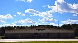
Burnsville City Hall
|
|

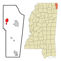
Location of Burnsville, Mississippi
|
|
| Country | United States |
| State | Mississippi |
| County | Tishomingo |
| Area | |
| • Total | 4.79 sq mi (12.41 km2) |
| • Land | 4.77 sq mi (12.36 km2) |
| • Water | 0.02 sq mi (0.05 km2) |
| Elevation | 466 ft (142 m) |
| Population
(2020)
|
|
| • Total | 868 |
| • Density | 181.93/sq mi (70.25/km2) |
| Time zone | UTC-6 (Central (CST)) |
| • Summer (DST) | UTC-5 (CDT) |
| ZIP code |
38833
|
| Area code(s) | 662 |
| FIPS code | 28-09820 |
| GNIS feature ID | 2405349 |
Burnsville is a small town located in Tishomingo County, in the northeastern part of Mississippi, United States. In 2010, about 936 people lived here. The latest count in 2020 showed 868 residents.
Contents
Exploring Burnsville's Location
Burnsville is found on the west side of the Tennessee–Tombigbee Waterway. This waterway is like a big canal system. The town is also where two main roads meet: US Route 72 and Mississippi Highway 365.
Major Roads and Directions
- US Route 72 goes through the southern part of Burnsville.
- Mississippi Highway 365 runs north and south through the main part of town.
- It goes north about 6 kilometers (4 miles) to Doskie.
- It goes south towards Bay Springs Lake.
Land and Water Area
The town covers a total area of about 12.4 square kilometers (4.8 square miles). Most of this area is land. Only a tiny part, about 0.1 square kilometers (0.04 square miles), is water.
Rivers and Streams Nearby
Burnsville is close to several important water bodies:
- Little Yellow Creek
- Yellow Creek
- The Tennessee-Tombigbee Waterway
Other Natural Features
- Turnpike Hill is a notable landform. It lies just east of the town. It is also on the east side of the Tennessee-Tombigbee Waterway.
People Living in Burnsville
The number of people living in Burnsville has changed over the years. A "census" is a count of all the people in a place.
| Historical population | |||
|---|---|---|---|
| Census | Pop. | %± | |
| 1880 | 240 | — | |
| 1890 | 318 | 32.5% | |
| 1900 | 222 | −30.2% | |
| 1910 | 336 | 51.4% | |
| 1920 | 363 | 8.0% | |
| 1930 | 404 | 11.3% | |
| 1940 | 449 | 11.1% | |
| 1950 | 525 | 16.9% | |
| 1960 | 416 | −20.8% | |
| 1970 | 435 | 4.6% | |
| 1980 | 889 | 104.4% | |
| 1990 | 949 | 6.7% | |
| 2000 | 1,034 | 9.0% | |
| 2010 | 936 | −9.5% | |
| 2020 | 868 | −7.3% | |
| U.S. Decennial Census | |||
Burnsville's Population in 2020
In the 2020 United States census, there were 868 people living in Burnsville. These people lived in 353 households, which are like homes or families. About 199 of these were families.
Here's a look at the different groups of people in Burnsville in 2020:
| Race | Number of People | Percentage |
|---|---|---|
| White (not Hispanic) | 803 | 92.51% |
| Black or African American (not Hispanic) | 4 | 0.46% |
| Native American | 5 | 0.58% |
| Asian | 1 | 0.12% |
| Other/Mixed | 35 | 4.03% |
| Hispanic or Latino | 20 | 2.3% |
Learning and Libraries
Public Schools
The local schools are part of the Tishomingo County School District.
- Burnsville Elementary School teaches students from kindergarten to 8th grade. It has about 498 students.
Local Libraries
- The Burnsville Public Library is a great place to find books. It has a collection of about 179,000 books and other reading materials.
Getting Around Burnsville
Highways for Travel
- U.S. Route 72 is a major road that runs east to west. It connects cities like Chattanooga, Tennessee and Memphis.
- Mississippi Highway 365 runs north and south through Tishomingo County.
Railroads
- The Southern Railway System also serves the area.
Local Media
- WOWL 91.9 FM is a local radio station. It is owned by Southern Community Services, Inc.
Famous People from Burnsville
- Lester Carpenter is a notable person from Burnsville. He is a member of the Mississippi House of Representatives. He represents the First District of Mississippi.
See also
 In Spanish: Burnsville (Misisipi) para niños
 | Kyle Baker |
 | Joseph Yoakum |
 | Laura Wheeler Waring |
 | Henry Ossawa Tanner |


