Franklin County, Alabama facts for kids
Quick facts for kids
Franklin County
|
||
|---|---|---|

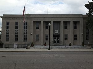
Franklin County Courthouse in Russellville
|
||
|
||

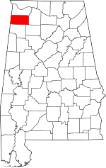
Location within the U.S. state of Alabama
|
||
 Alabama's location within the U.S. |
||
| Country | ||
| State | ||
| Founded | February 6, 1818 | |
| Named for | Benjamin Franklin | |
| Seat | Russellville | |
| Largest city | Russellville | |
| Area | ||
| • Total | 647 sq mi (1,680 km2) | |
| • Land | 634 sq mi (1,640 km2) | |
| • Water | 13 sq mi (30 km2) 2.0% | |
| Population
(2020)
|
||
| • Total | 32,113 | |
| • Estimate
(2023)
|
31,802 |
|
| • Density | 49.63/sq mi (19.164/km2) | |
| Time zone | UTC−6 (Central) | |
| • Summer (DST) | UTC−5 (CDT) | |
| Congressional district | 4th | |
|
||
Franklin County is a county in the state of Alabama. It is located in the United States. In 2020, about 32,113 people lived there.
The main town and county seat is Russellville. The county is named after Benjamin Franklin. He was a famous statesman, scientist, and printer.
Franklin County is a "dry county." This means that selling alcohol is generally not allowed. However, the city of Russellville is an exception, where alcohol sales are permitted.
Contents
History of Franklin County
Franklin County was created on February 6, 1818.
How Colbert County Was Formed
Part of Franklin County used to be Colbert County. Colbert County was first formed on February 6, 1867. This happened after the American Civil War because of political disagreements.
Eight months later, Colbert County was temporarily closed down. But it was started again on February 24, 1870.
Music from Franklin County
Many talented musicians and songwriters come from Franklin County. Some of these include Billy Sherrill, Ricky Pierce, Kerry Gilbert, and Eddie Martin.
Geography of Franklin County
Franklin County covers about 647 square miles. Most of this area, about 634 square miles, is land. The rest, about 13 square miles, is water.
Neighboring Counties
Franklin County shares borders with several other counties:
- Colbert County (to the north)
- Lawrence County (to the east)
- Winston County (to the southeast)
- Marion County (to the south)
- Itawamba County, Mississippi (to the southwest)
- Tishomingo County, Mississippi (to the northwest)
Protected Natural Areas
Part of the William B. Bankhead National Forest is located in Franklin County. This is a special area protected for nature.
Transportation
Main Roads
Several important highways pass through Franklin County:
 U.S. Highway 43
 State Route 13
 State Route 17
 State Route 19
 State Route 24
 State Route 172
 State Route 187
 State Route 237
 State Route 241
 State Route 243
 State Route 247
Railways
Trains also travel through Franklin County on these railway lines:
- Norfolk Southern Railway
- Redmont Railway
Population Information
| Historical population | |||
|---|---|---|---|
| Census | Pop. | %± | |
| 1820 | 4,988 | — | |
| 1830 | 11,078 | 122.1% | |
| 1840 | 14,270 | 28.8% | |
| 1850 | 19,610 | 37.4% | |
| 1860 | 18,627 | −5.0% | |
| 1870 | 8,006 | −57.0% | |
| 1880 | 9,155 | 14.4% | |
| 1890 | 10,681 | 16.7% | |
| 1900 | 16,511 | 54.6% | |
| 1910 | 19,369 | 17.3% | |
| 1920 | 22,011 | 13.6% | |
| 1930 | 25,372 | 15.3% | |
| 1940 | 27,552 | 8.6% | |
| 1950 | 25,705 | −6.7% | |
| 1960 | 21,988 | −14.5% | |
| 1970 | 23,933 | 8.8% | |
| 1980 | 28,350 | 18.5% | |
| 1990 | 27,814 | −1.9% | |
| 2000 | 31,223 | 12.3% | |
| 2010 | 31,704 | 1.5% | |
| 2020 | 32,113 | 1.3% | |
| 2023 (est.) | 31,802 | 0.3% | |
| U.S. Decennial Census 1790–1960 1900–1990 1990–2000 2010–2020 |
|||
In 2020, the population of Franklin County was 32,113 people. There were 11,048 households and 7,669 families living in the county.
Population in 2010
In 2010, there were 31,704 people living in Franklin County. About 24.8% of the people were under 18 years old. The average age was 37.8 years.
Education
Franklin County has two main school systems and one community college. These are Russellville City Schools and Franklin County Schools. Northwest Shoals Community College has a campus in Phil Campbell.
Russellville City Schools
- Russellville High School
- Russellville Middle School
- Russellville Elementary School (for grades 3 to 5)
- West Elementary School (for Kindergarten to grade 2)
Franklin County Schools
- Belgreen High School (for grades K to 12)
- East Franklin Junior High School (for grades K to 9)
- Phil Campbell High School (for grades K to 12)
- Red Bay High School (for grades K to 12)
- Tharptown High School (for grades K to 12)
- Vina High School (for grades K to 12)
There is also the Franklin County Career-Technical Center. It is located next to Belgreen High School.
Communities in Franklin County
Cities
- Red Bay
- Russellville (the county seat)
Towns
Census-designated places
These are areas that are like towns but are not officially incorporated:
Unincorporated communities
These are smaller communities that are not officially part of a city or town:
- Atwood
- Burntout
- Frankfort
- Halltown
- Liberty Hill
- Nix
- Old Burleson
- Pleasant Site
- Pogo
See also
 In Spanish: Condado de Franklin (Alabama) para niños
 | Stephanie Wilson |
 | Charles Bolden |
 | Ronald McNair |
 | Frederick D. Gregory |


