Winston County, Alabama facts for kids
Quick facts for kids
Winston County
|
|
|---|---|

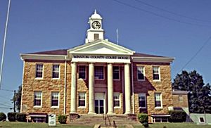
Winston County Courthouse in Double Springs
|
|

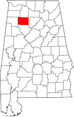
Location within the U.S. state of Alabama
|
|
 Alabama's location within the U.S. |
|
| Country | |
| State | |
| Founded | February 12, 1850 |
| Named for | John A. Winston |
| Seat | Double Springs |
| Largest city | Haleyville |
| Area | |
| • Total | 632 sq mi (1,640 km2) |
| • Land | 613 sq mi (1,590 km2) |
| • Water | 19 sq mi (50 km2) 3.0% |
| Population
(2020)
|
|
| • Total | 23,540 |
| • Estimate
(2023)
|
23,611 |
| • Density | 37.25/sq mi (14.381/km2) |
| Time zone | UTC−6 (Central) |
| • Summer (DST) | UTC−5 (CDT) |
| Congressional district | 4th |
|
|
Winston County is a special area in the state of Alabama, USA. It's like a big neighborhood with its own government. In 2020, about 23,540 people lived there. The main town, where the county government is located, is called Double Springs.
Before 1858, this area was known as Hancock County. It was later renamed Winston County to honor John A. Winston, who was the fifteenth Governor of Alabama.
Contents
History of Winston County
Winston County started on February 12, 1850. Back then, it was called Hancock County. It was created from a part of Walker County, which is just south of Winston County. The first name, Hancock County, honored John Hancock. He was a famous Governor of Massachusetts and a signer of the American Declaration of Independence. The first main town was Houston.
On January 22, 1858, the county's name changed to Winston County. This was to honor Alabama's Governor, John A. Winston.
The "Free State of Winston"
During the American Civil War, Winston County became famous for something special. Many people there did not agree with the idea of states leaving the United States (called secession). This feeling was so strong that the county is sometimes called the "Free State of Winston".
People in Winston County owned very few slaves. Because of this, they didn't see any good reason to join the states that wanted to leave the country. Today, the county uses its "Free State of Winston" nickname to attract visitors. This interesting part of history is even mentioned in famous books like To Kill a Mockingbird and Addie Pray.
Moving the County Seat
In 1883, the main town of Winston County moved from Houston to Double Springs. This happened because Cullman County was created from the eastern part of Winston County. Double Springs was a better choice because it was closer to the center of the county.
Famous People from Winston County
A very important judge named Frank Minis Johnson was born in Delmar, which is in Winston County. He was a judge for the U.S. Court of Appeals for the Eleventh Circuit. He played a big role in the civil rights movement, working to make sure everyone had equal rights.
Historic Places in Winston County
Winston County has four places that are listed on the National Register of Historic Places. This means they are important historical sites that are protected. These places are:
- Archeological Site No. 1WI50
- Feldman's Department Store
- the Houston Jail
- the Winston County Courthouse
Geography of Winston County
Winston County covers a total area of about 631 square miles. Most of this area, about 613 square miles, is land. The rest, about 1.9 square miles, is water.
Neighboring Counties
Winston County shares its borders with several other counties:
- Lawrence County (to the north)
- Cullman County (to the east)
- Walker County (to the south)
- Marion County (to the west)
- Franklin County (to the northwest)
Protected Natural Areas
Part of the William B. Bankhead National Forest is located in Winston County. This is a large area of protected forest land.
Population Information
Winston County's population has changed over the years. Here's how it has grown and shrunk:
| Historical population | |||
|---|---|---|---|
| Census | Pop. | %± | |
| 1850 | 1,542 | — | |
| 1860 | 3,576 | 131.9% | |
| 1870 | 4,155 | 16.2% | |
| 1880 | 4,253 | 2.4% | |
| 1890 | 6,552 | 54.1% | |
| 1900 | 9,554 | 45.8% | |
| 1910 | 12,855 | 34.6% | |
| 1920 | 14,378 | 11.8% | |
| 1930 | 15,596 | 8.5% | |
| 1940 | 18,746 | 20.2% | |
| 1950 | 18,250 | −2.6% | |
| 1960 | 14,858 | −18.6% | |
| 1970 | 16,654 | 12.1% | |
| 1980 | 21,953 | 31.8% | |
| 1990 | 22,053 | 0.5% | |
| 2000 | 24,843 | 12.7% | |
| 2010 | 24,484 | −1.4% | |
| 2020 | 23,540 | −3.9% | |
| 2023 (est.) | 23,611 | −3.6% | |
| U.S. Decennial Census 1790–1960 1900–1990 1990–2000 2010–2020 |
|||
In 2020, there were 23,540 people living in Winston County. There were 9,592 households (groups of people living together) and 6,268 families.
More About the Population
In 2010, the county had 24,484 people. Most of the people (95.6%) were White. About 2.6% of the population were Hispanic or Latino.
The average age of people in Winston County in 2010 was 43.1 years old. About 21.6% of the people were under 18 years old.
Religion in Winston County
In 2010, the main religious groups in Winston County included:
- Southern Baptist Convention (11,113 people)
- The United Methodist Church (1,117 people)
- Churches of Christ (978 people)
- Church of God (Cleveland) (784 people)
- Assemblies of God (295 people)
- Catholic Church (223 people)
Transportation in Winston County
You can travel through Winston County using several major roads and a railway.
Main Roads
 U.S. Highway 278
 State Route 5
 State Route 13
 State Route 33
 State Route 129
 State Route 195
 State Route 243
Railways
- Norfolk Southern Railway
Communities in Winston County
Winston County has one city, several towns, and some smaller communities.
City
- Haleyville (part of this city is also in Marion County)
Towns
- Addison
- Arley
- Double Springs (This is the county seat, where the main government offices are.)
- Lynn
- Natural Bridge
- Nauvoo (part of this town is also in Walker County)
Unincorporated Communities
These are smaller places that don't have their own local government like cities or towns.
Ghost Towns
These are places where people used to live, but now they are mostly empty.
See also
 In Spanish: Condado de Winston (Alabama) para niños
 | John T. Biggers |
 | Thomas Blackshear |
 | Mark Bradford |
 | Beverly Buchanan |

