Cullman County, Alabama facts for kids
Quick facts for kids
Cullman County
|
|
|---|---|

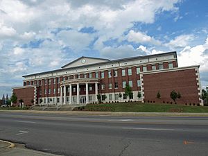
Cullman County Courthouse in Cullman
|
|

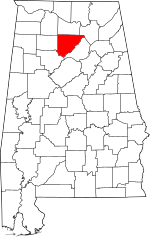
Location within the U.S. state of Alabama
|
|
 Alabama's location within the U.S. |
|
| Country | |
| State | |
| Founded | January 24, 1877 |
| Named for | John G. Cullmann |
| Seat | Cullman |
| Largest city | Cullman |
| Area | |
| • Total | 755 sq mi (1,960 km2) |
| • Land | 735 sq mi (1,900 km2) |
| • Water | 20 sq mi (50 km2) 2.7% |
| Population
(2020)
|
|
| • Total | 87,866 |
| • Estimate
(2023)
|
92,016 |
| • Density | 116.38/sq mi (44.934/km2) |
| Time zone | UTC−6 (Central) |
| • Summer (DST) | UTC−5 (CDT) |
| Congressional district | 4th |
|
|
Cullman County is a county in the north central part of Alabama. In 2020, about 87,866 people lived here. The main city and county seat is Cullman. The county is named after Colonel John G. Cullmann.
Cullman County is part of the Cullman, AL Micropolitan Statistical Area. This means it's a smaller city area that is closely connected to a larger city area, like Birmingham.
You can get TV and radio stations from both Huntsville and Birmingham here. Cullman County has some rules about selling alcohol. The cities of Cullman, Good Hope, and Hanceville allow alcohol sales. The rest of the county does not.
Contents
History
This area has been home to different groups of indigenous peoples for thousands of years. The Cherokee and Choctaw tribes lived here when Europeans first arrived. The Cherokee moved into Alabama after the American Revolutionary War. Their towns in Alabama were known as the Lower Towns.
Some people who say they are descendants of Cherokee who stayed in the county after the Indian Removal in the 1830s formed a group. This group is called the "Echota Cherokee Tribe of Alabama." The state of Alabama recognized them in 1984. However, the United States government does not officially recognize them.
Cullman County was officially started in 1877. Many German American immigrants from Cincinnati, Ohio, moved here. They wanted to create a strong farming community. They tried new ideas like growing wine grapes and strawberries. However, the land and local ways of life were sometimes different from what colonizer John G. Cullmann imagined. Even so, the German settlers worked hard and brought new farming methods.
On April 27, 2011, a very strong EF4 tornado hit Cullman. This was part of a huge storm system called the 2011 Super Outbreak.
Geography
Cullman County covers about 755 square miles. Most of this area, 735 square miles, is land. The remaining 20 square miles, or 2.7%, is water.
Neighboring Counties
- Morgan County (north)
- Marshall County (northeast)
- Blount County (east)
- Walker County (southwest)
- Winston County (west)
- Lawrence County (northwest)
Transportation
Main Roads
 Interstate 65
 U.S. Highway 31
 U.S. Highway 231
 U.S. Highway 278
 State Route 67
 State Route 69
 State Route 91
 State Route 157
Train Lines
Population
| Historical population | |||
|---|---|---|---|
| Census | Pop. | %± | |
| 1880 | 6,355 | — | |
| 1890 | 13,439 | 111.5% | |
| 1900 | 17,849 | 32.8% | |
| 1910 | 28,321 | 58.7% | |
| 1920 | 33,034 | 16.6% | |
| 1930 | 41,051 | 24.3% | |
| 1940 | 47,343 | 15.3% | |
| 1950 | 49,046 | 3.6% | |
| 1960 | 45,572 | −7.1% | |
| 1970 | 52,445 | 15.1% | |
| 1980 | 61,642 | 17.5% | |
| 1990 | 67,613 | 9.7% | |
| 2000 | 77,483 | 14.6% | |
| 2010 | 80,406 | 3.8% | |
| 2020 | 87,866 | 9.3% | |
| 2023 (est.) | 92,016 | 14.4% | |
| U.S. Decennial Census 1790–1960 1900–1990 1990–2000 2010–2020 |
|||
2020 Census Information
In 2020, Cullman County had 87,866 people. There were 32,090 households and 23,212 families living in the county.
2010 Census Information
In 2010, there were 80,406 people living in Cullman County. There were 31,864 households and 22,487 families. The population density was about 109 people per square mile.
About 23.2% of the people were under 18 years old. About 15.9% were 65 years or older. The average age was 39.9 years. For every 100 females, there were about 97.6 males.
The average income for a household was $38,567. For a family, it was $47,771. About 16.7% of the people in the county lived below the poverty line. This means they had lower incomes.
Education
Public schools in Cullman County are managed by two groups. The Cullman City School Board runs schools in the city of Cullman. The Cullman County School Board runs schools in all other areas.
- Cullman High School is one of the public high schools.
There are also several private schools in the county:
- Christ Covenant School (Grades K-2)
- Cullman Christian School (Grades K-12)
- Sacred Heart of Jesus Catholic Elementary School (Grades PreK-6)
- St. Bernard Preparatory School (Grades 7–12)
- St. Paul's Lutheran School (Grades K-6)
- Vinemont Christian Academy (Grades PreK-12)
Cullman County is also home to Wallace State Community College in Hanceville. It was named after former Governor George C. Wallace. The college opened in 1966. It is now the third largest community college in Alabama. About 6,000 students attend Wallace State.
The college offers many different degrees and certificates. These include programs in academics, health, and technical fields. Wallace State has more health programs than any other community college in the state. Students can also enroll early through programs like Dual Enrollment. The college has many sports teams, including basketball, baseball, softball, and golf.
Communities
Cities
- Arab (mostly in Marshall County)
- Cullman (county seat)
- Good Hope
- Hanceville
Towns
Census-designated places
- East Point
- Joppa (partly in Marshall County)
Unincorporated communities
- Arkadelphia
- Battleground
- Birdsong
- Black Bottom
- Bremen
- Brooklyn
- Bug Tussle
- Corinth
- Crane Hill
- Damascus
- Jones Chapel
- Logan
- Phelan
- Simcoe
- Spring Hill
- Trimble
- Vinemont
- Walter
- Welti
- Wilburn
- White City
See also
 In Spanish: Condado de Cullman para niños
 | Kyle Baker |
 | Joseph Yoakum |
 | Laura Wheeler Waring |
 | Henry Ossawa Tanner |

