Lawrence County, Alabama facts for kids
Quick facts for kids
Lawrence County
|
|
|---|---|

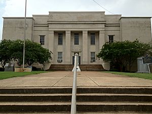
Lawrence County Courthouse in Moulton
|
|

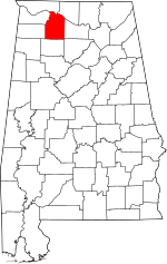
Location within the U.S. state of Alabama
|
|
 Alabama's location within the U.S. |
|
| Country | |
| State | |
| Founded | February 6, 1818 |
| Named for | James Lawrence |
| Seat | Moulton |
| Largest city | Moulton |
| Area | |
| • Total | 717 sq mi (1,860 km2) |
| • Land | 691 sq mi (1,790 km2) |
| • Water | 27 sq mi (70 km2) 3.7% |
| Population
(2020)
|
|
| • Total | 33,073 |
| • Estimate
(2023)
|
33,502 |
| • Density | 46.13/sq mi (17.810/km2) |
| Time zone | UTC−6 (Central) |
| • Summer (DST) | UTC−5 (CDT) |
| Congressional district | 4th |
|
|
Lawrence County is a place in northern Alabama. It's a type of area called a county. In 2020, about 33,073 people lived there. The main town, or county seat, is Moulton. The county got its name from James Lawrence. He was a brave captain in the United States Navy from New Jersey.
Lawrence County is part of the larger Decatur area. This area is important for jobs and businesses in Alabama.
Contents
History of Lawrence County
For thousands of years, different groups of indigenous peoples lived in this area. These were the first people to live here. One group, the Copena culture, built amazing earth mounds between 1 and 500 CE. These mounds were part of their religious and political life.
You can still see their large burial and ceremonial mounds at the Oakville Indian Mounds Park and Museum. The museum also teaches about the Cherokee people. They were an Iroquoian-speaking tribe who lived here when Europeans first arrived. Other Native American tribes in Alabama were the Choctaw and Creek.
Lawrence County was officially created on February 6, 1818. This happened when Alabama was still a territory. Later, in the 1830s, the U.S. government passed the Indian Removal Act. This law forced many Native American tribes from the Southeast to move west of the Mississippi River. They were moved to a place called Indian Territory. This was done so that more American settlers could move into the area.
Even after this, many Cherokee people and those with mixed European and Cherokee backgrounds stayed in Lawrence County. Today, the county has the most people who identify as Native American in Alabama. The Echota Cherokee Tribe of Alabama has a group called the Blue Clan here, with about 4,000 members.
Geography of Lawrence County
Lawrence County covers a total area of about 717 square miles. Most of this is land (691 square miles), and a smaller part is water (27 square miles).
Rivers
Neighboring Counties
- Limestone County (to the northeast)
- Morgan County (to the east)
- Cullman County (to the southeast)
- Winston County (to the south)
- Franklin County (to the west)
- Colbert County (to the west)
- Lauderdale County (to the northwest)
Protected Areas
- Part of the William B. Bankhead National Forest is in Lawrence County.
Transportation
Major Roads
Railroads
- Norfolk Southern Railway
Population Data
| Historical population | |||
|---|---|---|---|
| Census | Pop. | %± | |
| 1820 | 8,652 | — | |
| 1830 | 14,984 | 73.2% | |
| 1840 | 13,313 | −11.2% | |
| 1850 | 15,258 | 14.6% | |
| 1860 | 13,975 | −8.4% | |
| 1870 | 16,658 | 19.2% | |
| 1880 | 21,392 | 28.4% | |
| 1890 | 20,725 | −3.1% | |
| 1900 | 20,124 | −2.9% | |
| 1910 | 21,984 | 9.2% | |
| 1920 | 24,307 | 10.6% | |
| 1930 | 26,942 | 10.8% | |
| 1940 | 27,880 | 3.5% | |
| 1950 | 27,128 | −2.7% | |
| 1960 | 24,501 | −9.7% | |
| 1970 | 27,281 | 11.3% | |
| 1980 | 30,170 | 10.6% | |
| 1990 | 31,513 | 4.5% | |
| 2000 | 34,803 | 10.4% | |
| 2010 | 34,339 | −1.3% | |
| 2020 | 33,073 | −3.7% | |
| 2023 (est.) | 33,502 | −2.4% | |
| U.S. Decennial Census 1790–1960 1900–1990 1990–2000 2010–2020 |
|||
2020 Census Information
In 2020, the county had 33,073 people. There were 12,677 households and 9,101 families living there. Most people identified as White (about 74.7%). About 9.9% identified as Black or African American, and 4.3% as Native American. About 7.7% of people identified as being of mixed races. People of Hispanic or Latino background made up about 2.7% of the population.
2010 Census Information
In 2010, there were 34,339 people living in Lawrence County. The population density was about 50 people per square mile. Most people were White (77.6%), followed by Black or African American (11.5%), and Native American (5.7%). About 4.3% of people were from two or more races.
About 29.4% of households had children under 18. The average household had 2.50 people. The median age was 40.6 years old. This means half the people were younger than 40.6, and half were older.
Education in Lawrence County
All public schools in Lawrence County are part of the Lawrence County School District. The county has three high schools: East Lawrence, Hatton, and Lawrence County High Schools.
There are also six elementary schools: East Lawrence, Hatton, Hazlewood, Moulton, Mt. Hope, and Speake. For middle school, students attend East Lawrence or Moulton. Other important learning places include the Lawrence County Center of Technology and the Judy Jester Learning Center.
Some schools have changed over time. For example, R.A. Hubbard High School and Elementary School closed in 2022. Also, Speake, Mt. Hope, and Hazlewood schools changed from teaching K-12 grades to only K-6 grades in 2009.
Communities
Cities
- Moulton (This is the county seat, the main town)
Towns
Census Designated Places
Other Communities
- Caddo
- Chalybeate Springs
- Landersville
- Loosier
- Mount Hope
- Muck City
- Oakville
- Pittsburg
- Speake
- Wheeler
- Wolf Springs
- Wren
- Youngtown
Places to Visit
Lawrence County has many interesting places to visit. You can explore part of the William B. Bankhead National Forest. There's also the Oakville Indian Mounds, where you can learn about ancient cultures.
Another cool spot is the Jesse Owens Memorial Park, honoring the famous Olympic athlete. You can also visit Pond Spring, which was the home of General Joe Wheeler. The Black Warrior Path, an old trail used by Native Americans and pioneers, runs through the county and passes the Oakville Indian Mounds.
Events
Lawrence County hosts fun events every year. The AHSAA Cross Country state championships are held at the Oakville Indian Mounds. You can also enjoy the Alabama Multicultural Indian Festival, also at the Oakville Indian Mounds.
In Moulton, there's a Strawberry Festival. And at Pond Spring in Courtland, people celebrate General Joe Wheeler's Birthday Party. During December, the towns of Moulton and Courtland celebrate Christmas on the Square.
See also
 In Spanish: Condado de Lawrence (Alabama) para niños
 | Anna J. Cooper |
 | Mary McLeod Bethune |
 | Lillie Mae Bradford |


