Courtland, Alabama facts for kids
Quick facts for kids
Courtland, Alabama
|
||
|---|---|---|

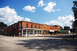
Buildings along the Town Square (College Street)
|
||
|
||

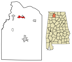
Location of Courtland in Lawrence County, Alabama.
|
||
| Country | United States | |
| State | Alabama | |
| County | Lawrence | |
| Incorporated | December 13, 1819 | |
| Area | ||
| • Total | 2.98 sq mi (7.71 km2) | |
| • Land | 2.95 sq mi (7.65 km2) | |
| • Water | 0.03 sq mi (0.06 km2) | |
| Elevation | 568 ft (173 m) | |
| Population
(2020)
|
||
| • Total | 583 | |
| • Density | 197.49/sq mi (76.24/km2) | |
| Time zone | UTC-6 (Central (CST)) | |
| • Summer (DST) | UTC-5 (CDT) | |
| ZIP code |
35618
|
|
| Area code(s) | 256 | |
| FIPS code | 01-18040 | |
| GNIS feature ID | 2406323 | |
Courtland is a small town located in Lawrence County, Alabama. It is part of the larger Decatur Metropolitan Area. In 2020, about 583 people lived there.
Contents
History of Courtland
Courtland has a long and interesting history, starting even before it became a town.
Early Days and Native Americans
A small stream called Big Nance Creek flows through Courtland. This creek was named after a Cherokee chief who lived in the area. It's believed that the town of Courtland is built on the site of an old Native American village.
In the early 1800s, Courtland began as a small settlement called Ebenezer. Many of its first settlers were wealthy farmers from states like Virginia, Tennessee, the Carolinas, and Georgia. The town was later named Courtland because a federal courthouse and land office were located there. In 1818, a group called the Courtland Land Company bought the land and divided it into lots for building. The town officially became a town on December 13, 1819.
Important Roads and Railroads
Two early roads, Gaines Trace and Byler Road, passed through Courtland. These roads were important for travel and trade in the early days.
One of the first railroads in the Southern United States was started in Courtland in 1831. It was called the Tuscumbia, Courtland and Decatur Railroad. This railroad was built to help people and goods travel around dangerous parts of the Tennessee River. It was about 50 miles (80 km) long. Later, this railroad became part of the Memphis and Charleston Railroad and then the Southern Railway.
The Red Rovers
In 1835, a doctor from Courtland named Jack Shackelford put together a group of volunteers. They went to fight in the Texas Revolution. This group was known as the "Red Rovers" because of their red uniforms. Sadly, most of the Red Rovers were captured by Mexican forces and were killed in an event known as the Goliad massacre. Dr. Shackelford was one of the few who survived.
World War II and the Airport
During World War II (1944-1945), Courtland was home to the Courtland Army Airfield. This was an important place for training pilots. After the war, the airfield was taken apart and given to the town. Today, it is used as the Courtland Airport.
Courtland Historic District
In the early 1990s, more than 100 buildings in Courtland were added to the National Register of Historic Places. This area is known as the Courtland Historic District. Most of these buildings were built between the 1830s and the 1930s. You can see many different styles of architecture, like Federal, Italianate, and Victorian.
The Town Square was part of the town's first plan from 1818-1819. Many of the shops and buildings around the square were built in the late 1800s and early 1900s. The old train station, which is now a community center, was built in the late 1880s. The Old Sherrod Hotel, built around 1930, provided housing for workers building the Tennessee Valley Authority.
The John McMahon House, a Federal-style home built around 1830, is also listed on the National Register of Historic Places. Another historic place, Rocky Hill Castle, was a large farm that used enslaved labor. Its famous house was taken down in 1961.
Geography
Courtland is located at 34°40′6″N 87°18′39″W / 34.66833°N 87.31083°W. It is situated along Big Nance Creek, which flows into the Tennessee River. The town is west of Decatur and southeast of Muscle Shoals. The town's borders reach northeast to U.S. Route 72. The town of North Courtland is right next to Courtland to the north.
The U.S. Census Bureau says that Courtland covers a total area of about 2.3 square miles (6.0 km2). Most of this area is land, with a very small amount of water.
Demographics
| Historical population | |||
|---|---|---|---|
| Census | Pop. | %± | |
| 1880 | 580 | — | |
| 1890 | 579 | −0.2% | |
| 1900 | 488 | −15.7% | |
| 1910 | 478 | −2.0% | |
| 1920 | 367 | −23.2% | |
| 1930 | 359 | −2.2% | |
| 1940 | 454 | 26.5% | |
| 1950 | 507 | 11.7% | |
| 1960 | 495 | −2.4% | |
| 1970 | 547 | 10.5% | |
| 1980 | 456 | −16.6% | |
| 1990 | 803 | 76.1% | |
| 2000 | 769 | −4.2% | |
| 2010 | 609 | −20.8% | |
| 2020 | 583 | −4.3% | |
| U.S. Decennial Census 2013 Estimate |
|||
From 1880 to 1910, Courtland was the biggest town in Lawrence County. But in 1920, Moulton became the largest town, and it still is today.
Population in 2020
| Race | Num. | Perc. |
|---|---|---|
| White (non-Hispanic) | 281 | 48.19% |
| Black or African American (non-Hispanic) | 241 | 41.34% |
| Native American | 9 | 1.54% |
| Pacific Islander | 1 | 0.17% |
| Other/Mixed | 51 | 8.75% |
| Hispanic or Latino | 8 | 1.37% |
According to the 2020 United States census, there were 583 people living in Courtland. There were 293 households and 211 families.
Notable People
- Sam Agee, an American football player
- Thomas Jefferson Foster, who served two terms in the Confederate Congress
- Jack Shackelford, one of the few people who survived the Goliad massacre
See also
 In Spanish: Courtland (Alabama) para niños
 | Shirley Ann Jackson |
 | Garett Morgan |
 | J. Ernest Wilkins Jr. |
 | Elijah McCoy |


