Carolinas facts for kids
Quick facts for kids
The Carolinas
|
|
|---|---|
|
Region
|
|
 |
|
| Country | |
| States | |
| Principal cities | |
| Largest metropolitan area | Charlotte-Concord-Gastonia |
| Largest city | Charlotte |
| Colonized as Province of Carolina |
1663 |
| Area | |
| • Total | 85,839 sq mi (222,320 km2) |
| • Land | 78,804 sq mi (204,100 km2) |
| • Water | 7,025 sq mi (18,190 km2) 8.2% |
| Population
(2019)
|
|
| • Total | 15,636,798 |
| • Density | 182.1643/sq mi (70.3340/km2) |
| Demonym(s) | Carolinian |
| GDP (nominal) | |
| • Total | $521.6 billion (2016) |
| • per capita | $42,244 (2016) |
| Time zone | UTC-5 (EST) |
| • Summer (DST) | UTC-4 (EDT) |
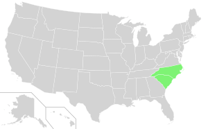
The Carolinas are two U.S. states that are often talked about together: North Carolina and South Carolina. They share borders with Virginia to the north, Tennessee to the west, and Georgia to the southwest. The Atlantic Ocean is to their east.
Together, North Carolina and South Carolina have a population of over 15.5 million people (as of 2020). If they were one single state, they would be the fifth-most populated state in the United States. Only California, Texas, Florida, and New York would have more people.
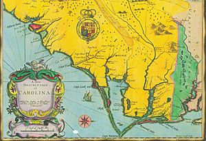
In America's early colonial days, from 1663 to 1710, this area was known as the Province of Carolina. Before that, from 1609 to 1663, it was part of the Colony of Virginia. The name Carolina was chosen to honor King Charles I of England. Later, in 1729, the large province was split into two separate royal colonies.
Contents
Exploring the History of the Carolinas
The Carolinas region was first claimed by Spain in 1513. Ponce de Leon named it La Florida. A Spanish settlement called Santa Elena was even the capital of La Florida from 1566 to 1587. It was built on what is now Parris Island, South Carolina.
Before Santa Elena, both the Spanish and the French tried to start colonies here. They were interested in the rich land of Chicora. Santa Elena was founded by Pedro Menéndez de Avilés after he destroyed the French Fort Caroline in 1565. Santa Elena became a busy community and a base for missionaries and soldiers. The Spanish even built other forts further inland, but they faced resistance from Native American tribes. Spain also lost interest in the area.
Santa Elena was left empty in 1587, and its people moved to St. Augustine. Spain then focused its efforts on other parts of America. The land was left to Native Americans until 1629. That's when King Charles I gave the land to Sir Robert Heath, calling it "Carolana" (from Carolus, Latin for 'Charles'). But this plan didn't work out.
How the Carolinas Became Two States
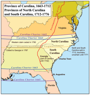
On March 24, 1663, King Charles II gave a new charter for Carolina to eight English noblemen. They were called Lords Proprietor. This was a reward for their loyalty. The charter gave them all the land from Virginia's southern border down to present-day Georgia. It also stretched all the way west to the Pacific Ocean, which was a huge claim!
The two separate colonies, North and South Carolina, didn't officially form until 1729. That's when seven of the eight Lords Proprietors sold their shares back to the King. Both North Carolina and South Carolina then became royal colonies, meaning they were directly controlled by the British Crown.
A few years later, in 1665, the charter was changed a bit. The northern border moved slightly north to include more land. The southern border also moved further south, even trying to include the Spanish settlement at St. Augustine. This was a big claim by the English, but it was hard to enforce.
Between 1663 and 1729, there were many disagreements. These included how to defend the colonies and how to govern them. There were also differences in farming styles between settlers from Virginia and those from the West Indies and Barbados.
In 1729, the Province of Carolina was officially divided. This happened when most of the Lords Proprietors sold their shares back to the Crown. Only the family of Sir George Carteret kept their rights to a small part of North Carolina. Both North Carolina and South Carolina became British Crown Colonies that year.
Understanding Carolina Culture
The culture of the Carolinas is a special part of the larger Southern culture. The coastal areas were settled by Europeans much earlier than inland parts of the South. They were also influenced by Caribbean culture, especially from Barbados. Many early governors of the united Carolina were from Barbados. Even though both states are in the South, they have historical differences in how they were settled, how their governments grew, and how their economies developed.
The Carolinas During the Civil War
During the American Civil War (1861–1865), South Carolina was the first Southern state to leave the Union. North Carolina was one of the last to leave. South Carolina was a strong supporter of the Confederacy. The war actually started in Charleston, South Carolina. Students from the South Carolina Military Academy, called The Citadel, fired the first shots at a Union ship.
North Carolina was also important to the Confederacy. It provided many soldiers. At the Battle of Gettysburg, one out of four Confederate soldiers was from North Carolina. However, some people in North Carolina, especially in the western part of the state, did not support the Confederacy. North Carolina's Civil War governor, Zebulon Baird Vance, often disagreed with Confederate President Jefferson Davis. Vance believed North Carolina's soldiers and supplies were needed for his own state's defense. Still, North Carolina sent many troops to help the South overall. Some North Carolinians even joined Union Army regiments.
The Carolinas were vital for the Confederacy because of their deepwater ports in Wilmington and Charleston. These cities were key for bringing in weapons, clothes, and ammunition. They also produced food for Southern civilians.
Politics in the Carolinas
For most of the 1900s, South Carolina was a very strong supporter of the Democratic Party. It often elected politicians who supported racial segregation, a system that kept people of different races separate. North Carolina was also mostly Democratic, but it had a larger group of Republicans. North Carolina was seen as more forward-thinking on issues like segregation and civil rights.
In 1947, a journalist named John Gunther wrote that North Carolina was "by a good deal the most progressive Southern state." But he described South Carolina as "one of the poorest American states, and probably one of the balkiest." He also noted that in North Carolina, divorce was possible, but South Carolina was the only state where it was not allowed at all.
Today, North Carolina is often a "swing state" in presidential elections, meaning it can vote for either party. South Carolina usually votes for Republican presidential candidates. However, a study in 2008 found that, despite these differences, North Carolina and South Carolina are actually the two most politically similar states in the country based on many different factors.
The Economy of the Carolinas
Historically, like much of the South, the Carolinas' economy was based on agriculture. Certain crops greatly shaped the region's economy.
Before World War II, North Carolina was mainly a region of small farms and factories. It relied heavily on a few crops that needed a lot of workers, like tobacco, cotton, and rice. The Carolinas also had many small factories making furniture, textiles, and tobacco products.
These industries gave the Carolinas, especially North Carolina, a stronger industrial base than most other Southern states. As machines took over more farming tasks, and as textile, clothing, and furniture jobs moved overseas, many small towns suffered.
In the late 1900s, both states started to grow in technology and banking. This brought new jobs, more people, and new types of businesses. These changes were more noticeable in North Carolina, while South Carolina's economic growth was slower for a few years.
Since the 1980s, North Carolina has become a major financial center. Charlotte is now the second-largest financial district in the United States, after New York City. Many large companies have their headquarters or major operations in Charlotte. These include Bank of America, Truist Financial, and Wells Fargo. Other big companies like Lowe's, Duke Energy, and Honeywell are also based there.
Professional Sports in the Carolinas
The Carolinas are home to several professional sports teams. Three of them are in the "Big Four major leagues":
- The Carolina Panthers play football in the NFL.
- The Charlotte Hornets play basketball in the NBA.
- The Carolina Hurricanes play ice hockey in the NHL.
All three of these teams are based in North Carolina, with two in Charlotte and one in Raleigh. Both states support them.
Professional sports teams first appeared in the Carolinas in the late 1900s. The oldest team is the Charlotte Hornets, started in 1988. The newest is Major League Soccer's Charlotte FC, which began playing in 2022. The Hornets were called the Bobcats from 2004–2014, then changed back to the Hornets. The Hurricanes started in 1971 as the New England Whalers. They moved to Raleigh, North Carolina, in 1997. The Hurricanes are the most successful team, winning the Stanley Cup championship in 2006. This was the first major professional sports title for the region.
Charlotte has hosted the NBA All-Star Game several times, including in 1991 and 2019. Bank of America Stadium in Charlotte hosts major college football games. Charlotte Motor Speedway hosts three big NASCAR events each year.
The Carolinas have produced many NBA superstars. These include Chris Paul, Stephen Curry, and Michael Jordan from North Carolina. From South Carolina, famous players include Kevin Garnett and Zion Williamson. A lot of great basketball players come from the Carolinas, similar to big cities like New York and Los Angeles. North Carolina is also home to three very successful college basketball teams: the North Carolina Tar Heels, North Carolina State Wolfpack, and the Duke Blue Devils. These three rival schools have won many NCAA Men's Division I Basketball Championships.
The Border Between the States
Figuring out the exact border between North and South Carolina has been a long process. It started in 1720. An agreement in 1730 said the border should begin 30 miles southwest of the Cape Fear River.
In May 1735, surveyors started marking the line. They went west from the Cape Fear River along the coast, then turned northwest. The survey continued in stages over many years. In 1772, adjustments were made to keep the Catawba Indians in South Carolina. However, some parts of the survey were incorrect, leading to land being accidentally given to the wrong state.
North Carolina didn't agree to the 1772 line until 1813. Later surveys in 1905 and 1928 helped define other parts of the border.
Recent Border Updates
In the mid-1990s, a company called Duke Energy realized the border needed to be re-surveyed. This was because they were selling land that crossed both states. Also, as more people moved to rural areas, it became important to know the exact lines for fire, tax, and school districts. This was especially tricky in the mountains, where the border often ran along ridges.
To avoid expensive lawsuits, North and South Carolina agreed in 1993 to work together to re-survey the border. They used old maps from the 1800s and modern GPS technology. Some old stone markers still said "NC/SC 1815 AD," but many original markers were trees that no longer existed.
After 18 years and nearly a million dollars, the process was almost finished by 2012. It was discovered that a gas station and about 30 homes might change states. For example, the Lake Wylie Mini Market, which was thought to be in South Carolina, would move to North Carolina. This would mean higher gas taxes and different laws for things like fireworks. Both states planned to pass laws to help people affected by these border changes.
In February 2014, officials met to decide what to do. People in homes that changed states would need new driver's licenses and to register to vote in their new state. Laws could be passed to let people keep their utilities, avoid paying back taxes to the new state, and stay in the same schools.
On December 9, 2016, North Carolina Governor Pat McCrory signed an order officially defining the border based on 20 years of work. This finally settled the long-standing border questions between the two states.
Major Cities in the Carolinas
The Carolinas have several large and important cities. Here are some of the most populated ones:
| Rank | City | Population (2018) | Population (2010) | Change | Area (sq mi) |
|---|---|---|---|---|---|
| 1 | Charlotte, North Carolina | 872,498 | 731,424 | +19.29% | 297.7 |
| 2 | Raleigh, North Carolina | 469,298 | 403,892 | +16.19% | 144.8 |
| 3 | Greensboro, North Carolina | 294,722 | 269,666 | +9.29% | 131.2 |
| 4 | Winston-Salem, North Carolina | 246,328 | 230,047 | +7.08% | 133.7 |
| 5 | Charleston, South Carolina | 136,208 | 120,083 | +13.43% | 127.5 |
| 6 | Columbia, South Carolina | 133,451 | 129,272 | +3.23% | 134.9 |
| 7 | Greenville, South Carolina | 68,563 | 58,409 | +17.38% | 28.8 |
Images for kids
See also
 In Spanish: Las Carolinas para niños
 | James Van Der Zee |
 | Alma Thomas |
 | Ellis Wilson |
 | Margaret Taylor-Burroughs |


