
Province of North Carolina facts for kids
Quick facts for kids Province of North Carolina |
|||||||||
|---|---|---|---|---|---|---|---|---|---|
| Province of Great Britain | |||||||||
| 1712–1776 | |||||||||
 Location of the Province of North Carolina in North America |
|||||||||
| Anthem | |||||||||
| "God Save the King" |
|||||||||
| Capital | |||||||||
| Area | |||||||||
| • Coordinates | 35°45′N 83°00′W / 35.75°N 83.00°W | ||||||||
| Government | |||||||||
| • Type | Proprietary colony (1712–1729) Crown colony (1729–1776) |
||||||||
| • Motto | Quae Sera Tamen Respexit (Latin) "Which, though late, looked upon me" |
||||||||
| Monarch | |||||||||
|
• 1712–1714
|
Anne | ||||||||
|
• 1714–1727
|
George I | ||||||||
|
• 1727–1760
|
George II | ||||||||
|
• 1760–1776
|
George III | ||||||||
| Governor | |||||||||
|
• 1712
|
Edward Hyde (first) | ||||||||
|
• 1771–1776
|
Josiah Martin (last) | ||||||||
| Legislature | General Assembly | ||||||||
|
• Upper house
|
Council | ||||||||
|
• Lower house
|
House of Burgesses | ||||||||
| Historical era | Georgian era | ||||||||
|
• Partition of Carolina
|
24 January 1712 | ||||||||
| 4 July 1776 | |||||||||
|
|||||||||
| Today part of | United States
|
||||||||

.svg)
The Province of North Carolina was a British colony in North America. It existed from 1712 to 1776. At first, it was called Albemarle Province. It was one of the thirteen American colonies that later formed the United States.
North Carolina was first a proprietary colony. This meant a group of owners, called lords proprietor, controlled it. Later, it became a royal colony, meaning the British King or Queen directly ruled it. The King's representative was the Governor of North Carolina. The colony declared its independence on July 4, 1776.
Contents
What Does "Carolina" Mean?
The name "Carolina" comes from the Latin word "Carolus". This word means "Charles". The colony was named to honor King Charles II.
King Charles II first used this name in 1663. He gave a special document, called a Royal Charter, to eight important people. This charter gave them the right to settle lands in North America. These lands included parts of what are now North Carolina, Tennessee, South Carolina, Georgia, Alabama, Mississippi, and Florida.
How North Carolina Became a Colony
The Carolina Colony Begins

In 1663, King Charles II gave the Charter of Carolina. This land was south of the British Colony of Virginia. It was also north of Spanish Florida. The King gave this land to eight lords proprietor. He did this because they helped him financially and politically. They helped him get his throne back in 1660.
The land given to them was very large. It included all or part of many future U.S. states. These were North Carolina, Tennessee, South Carolina, Georgia, Alabama, Mississippi, and Florida.
Splitting into North and South Carolina
The northern part of the Province of Carolina was very different from the southern part. It was hard to travel and communicate between the two areas. So, in 1691, a separate deputy governor was chosen for the northern region.
Carolina officially split into the Province of North Carolina and the Province of South Carolina in 1710. This happened at a meeting in London. The same lords proprietor still owned both colonies. Edward Hyde became the first governor of North Carolina.
Later, in 1719, people in South Carolina were unhappy with the proprietors. So, King George I started appointing the governor there directly. But the lords proprietor kept choosing North Carolina's governor.
Both Carolinas became royal colonies in 1729. This happened after the British government bought out most of the proprietors. One proprietor family, the Carterets, kept their share until 1776. Their land was known as the Granville District.
Life and Growth in the Colony

In 1755, Benjamin Franklin was the Postmaster-General for the American colonies. He chose James Davis as North Carolina's first postmaster. Davis was based in New Bern. That same year, the North Carolina Assembly hired Davis to carry mail. He carried it between Wilmington, North Carolina and Suffolk, Virginia.
By the late 1700s, many people moved to North Carolina. They came from Virginia and the Province of Pennsylvania. The Scots-Irish were a large group from Northern Ireland. They were the biggest immigrant group from the British Isles before the American Revolution. Many English settlers came as indentured servants. These were people who worked for a period to pay for their trip.
Just before the Revolution, North Carolina was the fastest-growing British colony.
Different Ways of Life
Life in eastern North Carolina was different from western North Carolina. The eastern part had large plantations. Wealthy planters grew tobacco and rice using slave labor. This area was settled mostly by people from rural England and the Scottish Highlands.
The western part, called the Piedmont, had small family farms. It was settled by Scots-Irish, English, and German Protestants. These were often independent farmers.
During the American Revolution, people in eastern North Carolina often stayed loyal to the King. They had strong business ties to Great Britain. But settlers in western North Carolina usually supported American independence.
Towns and Daily Life
North Carolina was mostly rural. It had few cities, towns, or villages. Local taverns were important places. They offered drinks and beds for travelers. They also served as meeting places for politicians and business people. Taverns brought together all kinds of people. This showed that fancy city culture was spreading even to distant parts of the English world.
The courthouse was usually the most important building in a county. Jails were often part of the courthouse. Some counties also built tobacco warehouses. These helped with the colony's main export crop.
Moving Westward

People started moving west early in the 1700s. This happened especially after the Tuscarora and Yamasee wars ended. These wars removed big barriers to settling further inland.
More people could move across the Appalachian Mountains after the French and Indian War. This war, and the Anglo-Cherokee War, weakened the Cherokee and Catawba tribes.
In 1763, King George III issued the Proclamation of 1763. This rule tried to prevent conflicts with Indians. It stopped settlement near rivers that flowed west towards the Mississippi River. This included North Carolina rivers like the French Broad and Watauga. People in North Carolina disliked this rule. It was not always followed, but it did slow down westward migration until after the Revolution.
Some settlers still moved west despite the rule. Several settlements formed beyond the Appalachian Mountains. The most famous was the Watauga Association. It formed in 1772 as an independent area within North Carolina. It even had its own written constitution. Famous frontiersmen like Daniel Boone traveled across the invisible line. They hunted for valuable animal furs to sell in eastern towns. Many also led groups who settled in the Tennessee River valley and Kentucky.
Geography of the Province
Counties and Maps
The oldest counties were Albemarle County (1664–1689) and Bath County (1696–1739). Between 1668 and 1774, 32 counties were created. Western counties like Anson and Rowan had unclear western borders. They stretched all the way to the Mississippi River. Later, the borders became clearer and included Cherokee lands in the west.
Two important maps of the province were made. One was by Edward Moseley in 1733. The other was by John Collet in 1770. Moseley was a surveyor and treasurer for North Carolina. He also helped map the border between North Carolina and Virginia in 1728. Older maps from the Age of Discovery also show the coastlines of North and South Carolina.
Important Towns and Ports
The Province of North Carolina had several ports with Customs Agents. These included Bath, Roanoke, Currituck Precinct, Brunswick (Cape Fear), and Beaufort (Topsail Inlet).
Between 1729 and 1775, 52 new towns were started. Some major towns were:
- Bath (started in 1705)
- Brunswick (founded after 1726, later destroyed)
- Campbellton (started in 1762)
- Edenton (started in 1712)
- Halifax (started in 1757)
- Hillsborough (1754)
- Newbern (settled in 1710, started in 1723)
- Salisbury (started in 1753)
- Wilmington (founded in 1732, started in 1739 or 1740)
Each of these nine towns had one representative in the North Carolina House of Burgesses in 1775. Campbellton and Cross Creek (started in 1765) later combined to form Fayetteville in 1783.
Population Growth
| Historical population | ||
|---|---|---|
| Year | Pop. | ±% |
| 1720 | 21,270 | — |
| 1730 | 30,000 | +41.0% |
| 1740 | 51,760 | +72.5% |
| 1750 | 72,984 | +41.0% |
| 1760 | 110,442 | +51.3% |
| 1770 | 197,200 | +78.6% |
| Source: 1720–1760; 1770 | ||
Images for kids
-
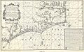
Map of North Carolina (1738)
-
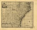
Map of North and South Carolina and Georgia (1752)


See also
 In Spanish: Provincia de Carolina del Norte para niños
