
Great Wagon Road facts for kids
The Great Wagon Road was an important path through the Great Appalachian Valley in colonial America. It stretched from Pennsylvania to North Carolina, and then all the way to Georgia.
This busy road was the main way for early settlers to move into the southern parts of the United States, especially the "backcountry" (which was the wild, less settled area). Many different kinds of people traveled south on this road. Two main groups were the German Palatines and the Scotch-Irish. They came in huge numbers because life was very hard in Europe.
The Germans, also called Pennsylvania Dutch, often looked for good farmland. They worked hard to become successful and build stable lives. The other group, sometimes called Presbyterians or Ulster Scots, were known for being adventurous and very independent. They helped create what we now call the Appalachian Culture. Because they spoke different languages, these two groups often stayed separate.
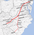
The Great Wagon Road started in Philadelphia, a big port city where many immigrants first arrived in the colonies. From there, it went through towns like Lancaster and York in southeastern Pennsylvania.
The Journey South


The road then turned southwest, crossing the Potomac River and entering the beautiful Shenandoah Valley near what is now Martinsburg, West Virginia. It continued south through the valley, following an old path called the Great Warriors' Trail. This trail had been used for hundreds of years by Native Americans and was originally created by herds of migrating buffalo. The part of the road in the Shenandoah Valley is also known as the Valley Pike.
In 1744, a special agreement called the Treaty of Lancaster gave colonists the right to settle along this Indian Road. After this treaty, many more people started using the road. However, traffic slowed down a lot during the French and Indian War (also known as the Seven Years' War) from 1756 to 1763. But once the war ended, the Great Wagon Road became the busiest main road in all of America!
South of the Shenandoah Valley, the road reached the Roanoke River at a town called Big Lick, which is now Roanoke. From Roanoke southward, the Great Wagon Road was also known as the Carolina Road. At Roanoke, one path branched off to the southwest, leading into the New River Valley and then to the Holston River in the Tennessee Valley. From there, another famous path, the Wilderness Road, went into Kentucky. It ended at the Ohio River, where travelers could find flatboats to continue their journey into the Midwest or even all the way to New Orleans.
After 1748, the Great Wagon Road from Big Lick/Roanoke passed through Maggoty Gap (a mountain pass) to the east side of the Blue Ridge Mountains. It continued south through the Piedmont region, going through towns in North Carolina like Winston-Salem, Salisbury, and Charlotte. These towns were often built on sites of older Native American settlements along the historic Indian Trading Path. The Great Wagon Road finally reached Augusta, Georgia, on the Savannah River. This was a long journey, more than 800 miles (1,287 km) from Philadelphia!
Traveling the Road


Even though it was called the "Wagon Road," the southern parts of this path weren't always wide enough for wagons until later in colonial times. For example, a map from 1751 only used the word "Waggon" for the road north of Winchester, Virginia. In 1753, some wagon travelers said that the "good road" ended at Augusta (which is now Staunton, Virginia), even though they kept going to Winston-Salem.
By all accounts, traveling on the Great Wagon Road was never easy. Long lines of settlers' covered wagons moved south, while other wagons full of farm goods headed north to sell their produce in cities. You would also see huge herds of cattle, hogs, and other animals being driven north to market.
While some parts of the road might have been pleasant, conditions could change quickly. Travelers might face deep mud or thick dust, mixed with animal waste. People preferred roads that were high and dry, but they also needed places to find water for their horses and themselves. Inns were often built near flowing springs, but they usually offered only very basic food and a place to sleep.
Today, you can still explore many parts of the old road by car, bike, or even on foot. While most of the road has changed a lot over time, some areas still look much like they did when the pioneers traveled through them.
Road Sections Overview

The Great Wagon Road was made up of many smaller sections. Here's a quick look at the main parts of this historic route:
- Philadelphia to York, Pennsylvania: This was the starting point for many immigrants. The road here was sometimes called the "King's Road."
- York, Pennsylvania to Winchester, Virginia: There were a few ways to go here, including the Old Monocacy Road, Nichols Gap, and Black's Gap. These paths eventually met up at Winchester.
- Winchester to Roanoke, Virginia: This section went through the beautiful Shenandoah Valley.
- Roanoke, Virginia to Wachovia, North Carolina: This part of the road crossed the Blue Ridge Mountains.
- Wachovia to Salisbury, North Carolina: Travelers could choose between the Trading Ford route or the Shallow Ford route to reach Salisbury.
- Salisbury, North Carolina to Charlotte, North Carolina: This section continued the journey south through important towns.
- Charlotte, North Carolina to Augusta, Georgia: From Charlotte, there were two main paths to Augusta: one through Camden and Columbia, South Carolina, and another through Union and Columbia, South Carolina. There was also an alternate path from Union, South Carolina, through Pelzer.
The distances and exact paths were not always the same, as the road changed over time due to things like fallen trees or floods.
Images for kids
-
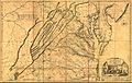
1751 Fry-Jefferson map depicting the Virginia Colony and surrounding provinces in 1752
-
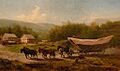
Conestoga wagons on the Great Road
-
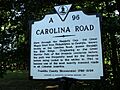
Historic marker for the Carolina Road, Franklin County, Virginia
-
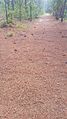
Remnant of the Great Wagon Road at Camden Battlefield, South Carolina
-
The Great Valley Road used by settlers in the 1700s America.
