Trading Path facts for kids
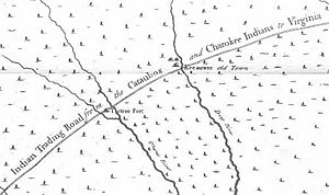
The Trading Path was a very old network of trails and roads. It wasn't just one single path, but many routes used for travel and trade. This important corridor connected the Chesapeake Bay area, especially near Petersburg, Virginia, to the lands of Native American groups like the Cherokee and Catawba. These lands were in the Piedmont region of North Carolina, South Carolina, and Georgia.
Native American people used and cared for these paths for hundreds of years. They had a huge trading network long before Europeans arrived. Both Native and later European settlements grew up along key points of the path. Parts of the Trading Path had other names too. For example, the section through the Carolina Piedmont was called the "Upper Road." The part between North Carolina and Georgia was known as the "Lower Cherokee Traders Path."
Contents
What Was the Trading Path?
The Trading Path was a very old and important route. It was a collection of trails and roads. It helped people travel and trade goods across a large area. Think of it like an ancient highway system.
Who Used the Path?
Both Native Americans and later European settlers used the Trading Path. Native people used it first for their own trading. They exchanged goods with other tribes. Later, European traders also used it to trade with Native Americans.
Why Was it Important for Trade?
The path was mainly used to carry goods for buying and selling. In early colonial times, traders from Virginia traveled south. They went to Native American towns in the Waxhaws region. This area is now near Mecklenburg County, North Carolina.
These traders led long lines of horses. The horses carried many items. These included guns, gunpowder, knives, jewelry, blankets, and hatchets. They traded these European goods for animal furs and deerskins.
The Path's Lasting Impact
The Trading Path was very well planned. It went through the tricky Piedmont area. It connected places where people could cross many streams. Because of its good design, later transportation routes followed it.
How Did it Influence Modern Roads?
In the 1800s, railroads were built. Many of these followed the Trading Path's route. Even more recently, engineers designed Interstate 85. This major highway also follows much of the old path. It goes from Petersburg, Virginia, all the way to the Georgia state border.
Towns and Cities Along the Path
Many of the first towns built along the Trading Path are still here today. You can even see parts of the old path in some places. The Piedmont Crescent is a busy area in North Carolina. It has grown a lot since the late 1800s. This area developed right along the Trading Path.
The cities in the Piedmont Crescent are very important. They are centers for government, money, education, and business in North Carolina.
 | Charles R. Drew |
 | Benjamin Banneker |
 | Jane C. Wright |
 | Roger Arliner Young |


