
Great Appalachian Valley facts for kids
The Great Valley, also known as the Great Appalachian Valley, is a huge valley system in eastern North America. It's like a long, deep ditch that runs through the middle of the Appalachian Mountains. This valley stretches for about 1,200 miles (1,900 km) from Quebec, Canada, all the way down to Alabama in the United States. For thousands of years, it has been an important path for travel from north to south.

Contents
Exploring the Great Valley's Geography
The Great Valley forms the eastern edge of a larger area called the Ridge-and-Valley Appalachians. Many parts of the Great Valley have their own local names, like the famous Shenandoah Valley. We can think of the Great Valley as having two main parts: a northern section and a southern section.
Northern Great Valley Regions
The northern part of the Great Valley includes several well-known areas. These are the Champlain Valley near Lake Champlain, the Hudson River Valley, and the Wallkill Valley. It also includes the Kittatinny Valley, the upper Delaware River Valley, the Lebanon Valley, and the Cumberland Valley.
Mountains surround the northern Great Valley on both sides. To the east, closer to the coast, you'll find the Green Mountains in Vermont. There are also the Taconic Mountains and the Reading Prong, which includes the Hudson Highlands. Further south is South Mountain in Pennsylvania. A large gap near Harrisburg connects the Great Valley to the Piedmont region. Some people see this gap as the dividing line between the northern and southern parts of the valley.
To the west, away from the coast, the northern Great Valley is bordered by more rugged mountains. The Adirondack Mountains reach the valley near Lake Champlain. South of them, the Catskill Mountains overlook the Hudson River. Further south, the Ridge-and-Valley Appalachians begin with a long ridge. This ridge is called the Shawangunk Ridge in New York, Kittatinny Mountain in New Jersey, and Blue Mountain in Pennsylvania. This long mountain wall has several narrow openings, called wind gaps and water gaps. Famous ones include the Delaware Water Gap and many others in Pennsylvania.
Southern Great Valley Regions
The southern part of the Great Valley is bordered on the east by the Blue Ridge Mountains. These mountains extend north into Maryland and Pennsylvania as South Mountain. The southern Great Valley has many local names too. These include the Hagerstown Valley in Maryland and the Shenandoah Valley in Virginia and West Virginia. Other parts are the Roanoke Valley and New River Valley in Virginia. The Holston River Valley in Virginia and Tennessee, and the East Tennessee Valley are also here. Some even include the Coosa River Valley in Alabama as the southernmost part. These southern areas are sometimes grouped as the Valley of Virginia and the Tennessee Valley.
The Blue Ridge Mountains form the eastern border of the southern Great Valley. This range includes the Unaka Range and the Great Smoky Mountains. An important gap near Roanoke, Virginia, connects the valley to other areas. Other gaps in Virginia's Blue Ridge include Thornton Gap and Rockfish Gap.
To the west, the southern Great Valley is bordered by other mountains. These include North Mountain, the Allegheny Front, and the Cumberland Mountains. The Cumberland Gap is a famous pass that connects the Great Valley to lands in Kentucky and Tennessee.
Inside the Valley of Virginia, you'll find Massanutten Mountain. This part of the valley is known for its karst features. This means it has many sinkholes and caverns formed by water dissolving rock.
Great Valley Climate
The climate of the Great Valley changes as you go from north to south. The northern third has a humid continental climate, which means it has warm or hot summers. From Pennsylvania southward, the climate becomes humid subtropical. This means it has hot, humid summers and mild winters.
History of the Great Valley
Long ago, Native Americans were the first to use the paths through the Great Valley. A major Indian trail, known as the Great Indian Warpath, ran through this area.
When European colonists arrived, the Great Valley became a key route for settlement and trade. The Great Wagon Road started in Philadelphia and ran through the valley. In the Shenandoah Valley, this road was called the Valley Pike. The Wilderness Road branched off near Roanoke, Virginia. It crossed the Cumberland Gap and led settlers to Kentucky and Tennessee. Another road, the Carolina Road, went into the Piedmont regions of the Carolinas and Georgia.
The gaps in the mountains were very important throughout history. The wide gap in southeast Pennsylvania was the main entry point for colonists. By the 1730s, the Great Valley in Pennsylvania was open for settlement. Many immigrants came, making it known as "the best poor man's country." Soon, people moved south into the Shenandoah Valley of Virginia. This entire region became famous for its farms, producing a lot of food. The road from Philadelphia through the valley became very busy. The Conestoga wagon, a large covered wagon, was developed around 1725. It became the main way to transport goods through the valley until railroads arrived.
Culver Gap in New Jersey was an important route for thousands of years. Lenape Native Americans used it for hunting and trading. Later, settlers used the water from Culvers Lake to power mills.
By the 1750s, the southern Shenandoah Valley was well-settled. Immigrants continued south to Roanoke, Virginia. A wide gap in the Blue Ridge Mountains there led to the Carolina Piedmont. This area offered good land at low prices. Towns like Salisbury and Charlotte quickly grew. Many of these settlers were Scots-Irish and Germans.
On the west side, the Cumberland Gap was the main path for people moving west from the southern Great Valley. In the north, the Mohawk Valley became a major route for westward expansion. This was especially true after the Erie Canal was built. The canal connected New York City to the Great Lakes region.
The Great Valley played a big role in the American Civil War. The Shenandoah Valley, its mountain gaps, and nearby areas saw many important events. These include Harpers Ferry, West Virginia, Antietam, Maryland, and the Gettysburg Campaign. Many battles and campaigns took place in this region.
Travel Through the Great Valley
Today, several major highways follow the Great Valley.
Interstate Highways in the Southern Valley
In the southern part of the Great Valley, the main highways are:
- I-81 from Harrisburg, Pennsylvania to near Dandridge, Tennessee.
- I-40 from the I-81 interchange to Knoxville.
- I-75 from Knoxville to Cleveland, Tennessee.
Interstate Highways in the Northern Valley
In the northern valley, the highways are a bit different.
- From Harrisburg, I-81 follows the valley for a bit, then leaves it.
- I-78 then continues through the valley, connecting Harrisburg with Lebanon and Allentown.
- From Allentown into New Jersey and New York, there isn't one main interstate. However, I-80 and I-84 cross the valley. The Delaware River also flows through it.
- Near Newburgh, I-87 runs north through much of the valley into Canada. It passes Poughkeepsie, Albany, and Glens Falls.
- In an east-west section, I-90 crosses the Mohawk Valley towards Utica.
- North of Glens Falls, I-87 goes through the Adirondack Mountains. It returns to the valley near Plattsburgh.
- At the Canada-US border, I-87 becomes Autoroute 15 and continues to Montreal.
- Further north, I-89 runs along the east side of Lake Champlain. It goes through the northernmost parts of the valley to the Canadian border. There, it becomes Quebec Route 133 and Autoroute 35. These roads follow the Richelieu River until the Great Valley fades into the Saint Lawrence River plain.
Culture and the Great Valley
The Great Valley, especially its southern and middle parts, is located within the region known as Appalachia. This area has its own unique culture and traditions.
Images for kids
-
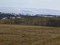
Blue Mountain in the Lehigh Valley region of Pennsylvania
.jpg)
