
Richelieu River facts for kids
Quick facts for kids Richelieu River |
|
|---|---|

Richelieu River at Saint-Marc-sur-Richelieu
|
|
| Country | Canada, and appreciable parts of New York State and Vermont |
| Physical characteristics | |
| Main source | Lake Champlain |
| River mouth | Saint Lawrence River at Sorel |
| Length | 124 km (77 mi) |
| Basin features | |
| Basin size | 23,720 km2 (9,160 sq mi) |


The Richelieu River is an important river in Quebec, Canada. It flows into the St. Lawrence River. The river starts at Lake Champlain and flows north through Quebec before joining the St. Lawrence. It used to be called the Iroquois River and the Chambly River.
For a long time, this river was a key way to transport goods between Canada and the United States. It offered a direct route from the Saint Lawrence River to New York City through Lake Champlain, the Champlain Canal, and the Hudson River. This was very important until trains became popular in the mid-1800s.
Because of its location between New France (what Canada was called back then) and New England, many forts were built along the river. It was a major path for armies and saw many battles from the late 1600s to the early 1800s. First, the French fought the Iroquois. Then, the French fought the English. After 1760, the British fought the Americans.
Template:TOC limit=3
Contents
Geography and Water Flow
The Richelieu River collects water from a huge area of about 23,720 square kilometers (9,158 square miles). This area includes Lake Champlain and Missisquoi Bay. Most of this area (about 19,600 square kilometers or 7,568 square miles) is in the United States. It gets water from the Green Mountains and the Adirondack Mountains in New York State. The Champlain Valley makes up most of this water collection area.
The Richelieu River is 124 kilometers (77 miles) long. It starts at the northern end of Lake Champlain, right on the border between Canada (Quebec) and the United States (Vermont and New York state). The river flows through many towns, including Lacolle, Île aux Noix, Saint-Jean-sur-Richelieu, Chambly, and Sorel-Tracy. At Sorel-Tracy, it empties into the Saint Lawrence River. This is about 40 kilometers (25 miles) northeast of Montreal.
The Richelieu River is the biggest river that flows into the south side of the Saint Lawrence River. It drains a large part of southern Quebec. The Quebec part of the river's watershed (about 15% of the total area) includes 18 lakes and ponds. It also has about 40 smaller rivers and streams that flow into the Richelieu. The main rivers that join the Richelieu are the Acadia, South Huron, and Lacolle rivers. On average, 330 cubic meters (11,654 cubic feet) of water flow through the river every second.
About 340,000 people live in the Quebec part of the river's watershed. This area has a high population density, meaning many people live close together. More than 70% of this land is used for farming.
When the Chambly Canal opened in 1843, boats could travel on the Richelieu between the Saint Lawrence River and Lake Champlain. At the southern end of Lake Champlain, the Champlain Canal (opened in 1823) connects to the Hudson River. This allowed boats to reach New York City, where the Hudson River flows into the Atlantic Ocean.
Important towns along the river include Saint-Jean-sur-Richelieu, Chambly, Beloeil, Mont-Saint-Hilaire, and Sorel-Tracy.
River Sections and Flow
The Richelieu River generally flows downhill at a gentle slope. However, there is a drop of 24 meters (79 feet) between Saint-Jean-sur-Richelieu and Chambly.
The Richelieu River is usually divided into three main parts:
- The Haut-Richelieu (Upper Richelieu): This part is between Lake Champlain and Saint-Jean-sur-Richelieu. It has a very small drop in elevation (only 0.3 meters or 1 foot over 35 kilometers or 22 miles). It is about 1.5 kilometers (0.9 miles) wide at its start, but it gets narrower, down to about 250 meters (820 feet) in some places. The city of Saint-Jean-sur-Richelieu is in this section.
- The Chambly Canal section: This part goes from Saint-Jean-sur-Richelieu to Chambly. Here, the river drops a lot – about 25 meters (82 feet) over 12 kilometers (7.5 miles). This creates many rapids. The Chambly Canal has nine locks and is almost 19 kilometers (12 miles) long. Locks are like water elevators that help boats go up or down hills. This canal allows boats to get past the rapids. In Chambly, the river widens into the Chambly Basin, which is a popular spot for boating.
- The Bas-Richelieu (Lower Richelieu): This section is between Chambly and the Saint Lawrence River. In this part, the river flows past towns like Beloeil and Mont-Saint-Hilaire. Near Saint-Ours, the river drops again before it flows into the Saint Lawrence River at Sorel-Tracy.
Several islands are found along the Richelieu River. One of the most famous is Île aux Noix, in the Haut-Richelieu. It is home to Fort Lennox, which is a national historic site in Canada. Downstream, Sainte-Thérèse Island is the largest island on the Richelieu. It is about 4 kilometers (2.5 miles) long and 1 kilometer (0.6 miles) wide. It used to be farmland but is now mostly homes. It also once had Fort Sainte Thérèse, built in 1665, but that fort is now gone.
The Richelieu is one of only three rivers in Quebec that flow from south to north. The other two are the Châteauguay and Chaudière rivers. Because of this, ice can melt in the south while the north is still frozen in spring. This can cause ice jams and floods.
Rivers Flowing into the Richelieu in Quebec
Here are some of the rivers that flow into the Richelieu River in Quebec:
- L'Acadie River (Rivière l'Acadie), 82 km (51 mi) long. It joins near Carignan.
- South River (Rivière Du Sud), 39.1 km (24.3 mi) long. It joins near Henryville.
- Amyot River (Rivière Amyot), 11.7 km (7.3 mi) long. It joins near Saint-Charles-sur-Richelieu.
- Lacolle River (Rivière Lacolle), 24 km (15 mi) long. It joins near Lacolle.
- Huron River (Rivière Des Hurons), 33 km (21 mi) long. It joins near Saint-Mathias-sur-Richelieu.
- Iroquois River (Rivière Des Iroquois), 10.1 km (6.3 mi) long. It joins near Saint-Jean-sur-Richelieu.
- Bernier River (Rivière Bernier), 12.9 km (8.0 mi) long. It joins near Saint-Jean-sur-Richelieu.
River History
Early People and Explorers
The Richelieu River area was originally home to the Iroquois and Abenaki Indigenous peoples.
In 1535, the French explorer Jacques Cartier found the mouth of the Richelieu River during his second trip to New France (Canada). Later, Samuel de Champlain and his team reached the river's mouth in 1603. Champlain returned in 1608 and 1609, exploring the river all the way up to where modern-day Albany, New York is located.
Naming the River
The river was once called "Masoliantekw" by the Abenaki, which means "water where there is plenty of food." Early maps and journals also called it the "Iroquois River" or the Sorel River. Its current French name comes from Cardinal Richelieu (1585–1642), who was a powerful minister for King Louis XIII. Cardinal Richelieu was important during the early years of French settlement in Quebec in the 1600s.
Forts and Battles
The Richelieu River was an important path for the Iroquois and later for French traders. The French built five forts along the river:
- Fort Richelieu at its mouth.
- Fort St. Louis (also known as Fort Chambly) in Chambly.
- Fort Sainte Thérèse and Fort Saint-Jean further upriver.
- Fort Ste. Anne on Isle La Motte in Lake Champlain.
In the 1600s, attacks by the Iroquois threatened the French colony. So, military posts like Fort Richelieu and Fort Saint-Jean were built. Fort Saint-Jean, built in 1666, led to the founding of the city of Saint-Jean, now called Saint-Jean-sur-Richelieu. In the 1700s, the area became very important for both the French and British empires. They both wanted to expand their land and control the fur trade.
Between 1819 and 1829, the British built Fort Lennox on an island in the Richelieu River. This fort was near the Canada-U.S. border. It was built to protect against possible attacks from Americans after the War of 1812. These forts and the rich farmland along the river attracted many farmers. This is how the Haut-Richelieu region got its nickname, the "Valley of the Strongholds" (Vallée des forts).
After the British took over New France in 1759–1760, and after the American Revolutionary War (1776–1783), British soldiers and loyalists settled along the Richelieu. During the Lower Canada Rebellion of 1837, battles like Saint-Denis and Saint-Charles took place along the river.
Economy and Transportation
In the 1800s, the Richelieu became a key route for trade instead of war. In 1843, the Chambly Canal was finished. This canal helped boats get past the rapids, making it easier to transport goods like wood, pulp, hay, and coal from Canada to the United States. This canal system allowed boats on the Richelieu to reach the Hudson River and then New York City. The cities of Sorel and Saint-Jean-sur-Richelieu grew quickly because of the increased boat traffic on the river.
However, by the late 1800s, railroads had largely replaced rivers for moving goods. A sad event happened in 1864 when a train fell off a bridge into the river, causing many deaths.
Tourism and Environment
Even though its use for trade has decreased, the Richelieu River is still important for fun activities like boating. Tourists visit New York and Montreal by traveling on the river. This helps the local economy. Saint-Jean became a very important inland harbor in Quebec and Canada. Today, tourism has largely replaced the old trade business on the Richelieu, which is now seen as a "heritage corridor."
The river flows through areas with many people and farms. This means it faces environmental challenges, especially in the Chambly Basin. However, efforts to treat wastewater have helped reduce pollution in recent years.
The Richelieu River caused major floods in the spring of 2011. These floods damaged or destroyed over 3,000 homes in Quebec and at least 750 in Vermont.
Geology of the Valley
The Richelieu River valley sits on top of sedimentary rocks. These rocks formed about 450 million years ago during the Cambrian period. The main rock types are shale and sandstone. Shale is a rock made from tiny pieces of older rocks. Sandstone is made of quartz grains stuck together, often from old shorelines.
The Utica shale in the area often contains shiny mica flakes and a lot of quartz. This type of shale can be used for shale gas extraction. Other shales in the Lorraine group are dark gray and have thin sandstone layers. These rocks cover most of the area.
Long ago, the region was covered by the sea, which led to the formation of marine sediments. Then, land movements pushed the area up, and it was eroded for a long time. Later, thick layers of ice covered the land during the Ice Age. After the glaciers melted, the Saint Lawrence Lowlands were flooded by the Champlain Sea. This sea left behind layers of clay and sand. When the land rose again, the sea retreated, leaving the area as it is today.
The valley is mostly flat and covered with a thick layer of clay, up to 50 meters (164 feet) deep. The most noticeable geological features in the river's watershed are the Monteregian Hills. Also, almost half of the Richelieu River's banks are still in their natural state.
Recreation and Fun
Even though the Richelieu River is not as important for trade anymore, it is still a great place for fun activities. The Chambly Canal has 9 locks that allow pleasure boats to go around the rapids at Saint-Jean-sur-Richelieu and Chambly. The Champlain Canal and Lake Champlain are part of the "Lakes to Locks Passage" in the U.S. This passage connects to the Hudson River, allowing boats to travel between the Saint Lawrence River and New York City, and even to the Erie Canal.
The Piste cyclable du Canal-de-Chambly is a 20-kilometer (12-mile) long bicycle path. It follows the old towpath along the canal. This bike path is part of Quebec's Route Verte bicycle network. The canal is a national historic site and is managed by Parks Canada. Parks Canada also looks after other historic sites along the river, like Fort Chambly, Fort Ste. Thérèse, and St. Ours Canal.
Because of the region's rich history, the Richelieu River and its islands have several historic sites. Some of these are owned by Parks Canada, such as the Canal Chambly National Historic Site, Fort Lennox, and Fort Saint-Jean. The Fort Chambly national historic site welcomes thousands of visitors each year, especially during the "Fête Bière et Saveurs" festival in early September. If you want to learn more about the region's history, you can visit the Musée du Haut-Richelieu in Saint-Jean-sur-Richelieu.
Fishing in the Richelieu
The Richelieu River is home to over 50 different kinds of fish. It offers great opportunities for sport fishing. You can catch fish like northern pike, longnose gar, bowfin, smallmouth bass, largemouth bass, carp, and black crappie.
However, the Richelieu also has several threatened or endangered fish. These include the copper redhorse, river redhorse, and lake sturgeon. Because of this, there are rules about when and how many fish you can catch to protect these special species.
The Montérégie region is known for its farm products. Many restaurants near the Richelieu River offer delicious food and beautiful views. The area is also famous for maple syrup and apple cider.
Wildlife and Plants
In the towns and farmlands, you can find small mammals like skunks, raccoons, squirrels, and groundhogs. Forest areas make up about 16% of the river's watershed. These forests are home to many different animals, including American mink, deer, beavers, frogs, and several kinds of turtles. One special turtle is the softshell turtle, which is an endangered species.
But the most common animals you'll see are birds. Because the river flows north-south, it's a major path for migrating birds. Near Saint-Jean-sur-Richelieu, there's a special spot where you can watch many different bird species. In the fall, for example, you can see thousands of geese and ducks arriving. You might also spot the loggerhead shrike (an endangered bird), as well as the peregrine and golden eagle (which are vulnerable species), and cerulean warblers.
As for plants, the river's area is part of a maple-hickory forest region. You can find sugar maple and silver maple trees, different kinds of hickory trees, bur oak and swamp white oak trees, American elms, and black ash trees. There are also many bushes and herbaceous plants. Several of these plants are considered vulnerable or endangered. Examples include the aplectrelle winter, the wild leek, and the Canada lily.
In the late 1990s, an invasive plant called water chestnut appeared at the mouth of the river. This plant can grow very quickly and threaten local plants and animals. The Quebec Ministry of Sustainable Development, Environment and Parks has been working to remove it. A special campaign started in 2001 to control this plant. Partners like CIME Haut-Richelieu have helped by harvesting the water chestnuts.
Fish Species and Protection

The Richelieu River is home to more than fifty types of fish. Many of them are considered endangered or threatened, such as the copper redhorse, river redhorse, and sturgeon. One of the last places where the copper redhorse (Moxostoma hubbsi) lays its eggs (called spawning) is in this river. This fish is special because it is found only in Quebec. Other fish, like the goby, are not native to the area. They were accidentally brought into the river's environment, often from water dumped from ship tanks that travel on the St. Lawrence River. These non-native fish are considered harmful or invasive. They can take over the water and compete with native fish, harming the river's ecosystem.
Over the last ten years, many ways have been tried to protect endangered fish. For example, in 2001, the Vianney-Legendre fish ladder was built. This ladder helps fish pass the dam at the Saint-Ours canal. It was named after Vianney-Legendre, a famous fish scientist. This special structure was designed to help different fish species, especially those that are threatened. It can even be used to teach people about protecting endangered fish.
In 2002, the Pierre-Étienne-Fortin wildlife refuge was created to protect a place where copper redhorse fish breed. Access to this refuge is not allowed during the breeding season, which is from late June to late July. Also, every summer since 2006, agents patrol the river to tell boaters about the copper redhorse and the rules to protect it.
Besides invasive species and more people using the river, pollution also affects fish. A report from 1998 found that pollutants and toxic chemicals in the river's water were "stressful" for fish. In some parts of the river, more than 13% of fish had problems, which showed that the fish community was not very healthy. However, because there were many fish-eating fish and some vulnerable species like banded killifish, the overall health of the fish was rated as "average" (except in Saint-Jean-sur-Richelieu, where it was "low"). Other fish like the black chin chub, stonecat, and East lamprey are also important "sentinel species" in the Richelieu River's watershed. This means their presence helps show the quality of the water. The information from the 1998 report is still used today.
Even with some fragile ecosystems, people can still enjoy sports and recreation on the river. Some fish in the river can grow very large, making them exciting for fishing. However, fishing is regulated. There are rules about how many fish you can catch each day and in certain areas, especially for sturgeons, knights, millers, and striped bass.
Images for kids
-
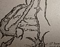
Map of Fort Saint-Jean and other forts on the Richelieu River circa 1666 for the campagne of the Regiment of Carignan-Salières
-
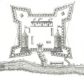
Fort Saint-Jean on Richelieu River in Canada during the 1750s
-
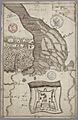
Map of 1695 with a plan of Fort Richelieu
-
Fort Saint-Jean circa 1775 siege of the fort
-
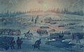
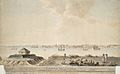
Passage of the Richelieu by night
-
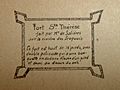
Fort Sainte-Thérèse on Richelieu River


See also
 In Spanish: Río Richelieu para niños
