
Chaudière River facts for kids
Quick facts for kids Chaudière |
|
|---|---|

Chutes-de-la-Chaudière
|
|

Chaudiere River basin
|
|
| Country | Canada |
| Province | Quebec |
| Physical characteristics | |
| Main source | Lake Mégantic Lac-Mégantic, Estrie 45°34′20″N 70°53′00″W / 45.57222°N 70.88333°W |
| River mouth | Saint Lawrence River Lévis, Chaudière-Appalaches 46°44′34″N 71°16′43″W / 46.74278°N 71.27861°W |
| Length | 185 km (115 mi) |
| Basin features | |
| Basin size | 6,682 km2 (2,580 sq mi) |
The Chaudière River is a long river in Quebec, Canada. Its name means "Cauldron" or "Boiler" in French. The Abenaki people, who are Indigenous to the area, call it Kikonteku. This river is about 185-kilometre-long (115 mi). It starts near the town of Lac-Mégantic in the Estrie region. From there, it flows north until it reaches the St. Lawrence River, right across from Quebec City.
Contents
Exploring the Chaudière River's Geography
The Chaudière River's drainage area is like a giant funnel, covering 6,682 square kilometres (2,580 sq mi). This area includes parts of the Appalachian Mountains and the lower lands near the St. Lawrence River. It has 236 lakes, which together cover 62 square kilometres (24 sq mi). About 180,000 people live in this river basin.
The river's flow changes throughout the year. On average, it carries about 114 cubic metres per second (4,000 cu ft/s) of water. During dry times, it can drop to 11 cubic metres per second (390 cu ft/s). But in spring, when snow melts, it can surge up to 470 cubic metres per second (17,000 cu ft/s). The highest flow ever recorded was 1,760 cubic metres per second (62,000 cu ft/s)!
What are the Main Rivers that Join the Chaudière?
Several smaller rivers flow into the Chaudière River. These are called its tributaries. The most important ones include:
- Rivière du Loup (also known as Rivière Linière)
- Famine River
- Beaurivage River
- Bras Saint-Victor
The river's basin is home to many different animals. Nearly half of all the vertebrate species known in Quebec can be found here. That's about 330 out of 653 species!
The river is also famous for the 40-metre-high (130 ft) Chaudière Falls. Both the river and the falls are popular spots for outdoor activities.
Which Towns and Cities Does the River Cross?
The Chaudière River flows through many towns and cities. These are grouped into regional county municipalities (MRC).
On the left side of the river (starting from where it meets the St. Lawrence):
- Lévis (in the "Saint-Rédempteur" and "Saint-Étienne-de-Lauzon" areas)
- MRC de la La Nouvelle-Beauce Regional County Municipality in Chaudière-Appalaches: Saint-Bernard, Saint-Lambert-de-Lauzon, Scott, Sainte-Marie-de-Beauce
- MRC Robert-Cliche Regional County Municipality in Chaudière-Appalaches: Saint-Joseph-des-Érables, Beauceville
- MRC Beauce-Sartigan in Chaudière-Appalaches: Notre-Dame-des-Pins, Saint-Georges-de-Beauce, Saint-Martin, Saint-Gédéon
- MRC Le Granit Regional County Municipality in Estrie: Saint-Ludger, Sainte-Cécile-de-Whitton, Lac-Mégantic
On the right side of the river (starting from where it meets the St. Lawrence):
- Lévis (in the "Charny" and "Sainte-Hélène-de-Breakeyville" areas)
- MRC de la La Nouvelle-Beauce Regional County Municipality in Chaudière-Appalaches: Sainte-Marie-de-Beauce, Vallée-Jonction
- MRC Robert-Cliche Regional County Municipality in Chaudière-Appalaches: Beauceville
- MRC of Beauce-Sartigan in Chaudière-Appalaches: Saint-Joseph-de-Beauce, Saint-Simon-les-Mines, Saint-Georges-de-Beauce, Saint-Martin, Saint-Gédéon
- MRC Le Granit Regional County Municipality in Estrie: Saint-Robert-Bellarmin, Frontenac, Audet, Lac-Mégantic (in the "Fatima" area)
The History of the Chaudière River
The Abenaki Indigenous people lived near the Chaudière Falls. They called the river "Kikonteku", which means "River of the Fields". Early maps by Samuel de Champlain called it the "Etchemin River". Later, it was known as "Rivière du Sault de la Chaudière". By the late 1700s, it became simply "Rivière Chaudière". This name refers to the amazing waterfall near where the river meets the St. Lawrence.
The river was very important for French settlers in the 1700s. It was a natural path between New France (what is now Quebec) and the British colonies to the south. During the invasion of Quebec in 1775, a general named Benedict Arnold used the river for his journey.
In 1823, people discovered gold along the river's banks in the Eastern Townships of Quebec.
On July 6, 2013, a train accident in Lac-Mégantic caused a large oil spill. This spill polluted the river at its source, Lake Mégantic. Towns downstream, like Saint-Georges, had to find other sources for their drinking water. People were asked to use less water. Special barriers were put in the river to try and stop the oil from spreading.
How the Chaudière River Shapes Life Today
The Chaudière Valley runs through the Beauce area of Quebec. The river greatly affects the industries and daily life there. Especially in spring, when the snow melts, the river often overflows into towns and villages. This happens even though there are 160 dams and walls built to control the water. The river flows through places like Sainte-Marie, Saint-Georges, Beauceville, and Saint-Joseph-de-Beauce.
The river is a fantastic place for outdoor activities. You can enjoy sports near Lake Mégantic and at Parc des Chutes-de-la-Chaudière. This park is close to where the river meets the St. Lawrence in Lévis. It has trails for cycling and hiking. There's even a footbridge hanging over the river, giving you an amazing view of the waterfalls!
The Chaudière Falls have been used to create hydro-electric power since the early 1900s. The dam was rebuilt in 1999. It now has a small power station that can produce 24 megawatts of electricity.
Bridges Over the Chaudière River
Many bridges cross the Chaudière River, connecting communities and allowing people to travel. Here are some of them:
| Bridge Name | Photo | Municipality (ies) | Year Built | Road or Path | Length | Bridge Type |
|---|---|---|---|---|---|---|
| Bridge 16179 | Lake Mégantic | Frontenac Street | Steel girder bridge | |||
| Railway bridge |  |
Lake Mégantic | Central Maine and Quebec Railway | Steel girder bridge | ||
| Bridge 18952 | Lake Mégantic | Papineau Street | Precast prestressed concrete girder bridge | |||
| Bridge | Lake Mégantic | Québec Central Trail | ||||
| Bridge 10965 | Lake Mégantic | 2005 | 110.6 metres (363 ft) | Steel girder bridge | ||
| Bridge 13899 | Lac-Drolet and Audet | 1969 | Main path | 68.4 metres (224 ft) | Precast prestressed concrete girder bridge | |
| Soucy Bridge | Saint-Ludger | 1958 | Pont Street | 61.5 metres (202 ft) | Reinforced concrete girder bridge | |
| Bridge | Saint-Martin | 2009 | Multifunctional trail | Suspended walkway | ||
| Bridge 13967 |  |
Saint-Martin | 1970 | 132.1 metres (433 ft) | Steel girder bridge | |
| Sartigan dam |  |
Saint-Georges | 1967 | Barrage-Sartigan road | Concrete-gravity dam | |
| David-Roy Bridge |  |
Saint-Georges | 1970 | 184.9 metres (607 ft) | Steel girder bridge | |
| Passerelle de la Seigneurie | .jpg) |
Saint-Georges | Cycle path of the Domaine de la Seigneurie | Steel girder walkway | ||
| Manac footbridge | Saint-Georges | Cycle path of the Domaine de la Seigneurie | Steel girder walkway | |||
| Canam-Boa Franc Gateway | Saint-Georges | Cycle path of the Domaine de la Seigneurie | Steel girder walkway | |||
| Bridge 13921 | Notre-Dame-des-Pins | 1969 | 30th Street | 279.6 metres (917 ft) | Precast prestressed concrete girder bridge | |
| Pont Perrault | _15.jpg) |
Notre-Dame-des-Pins | 1929 | Cycle lane | 150.9 metres (495 ft) | Covered bridge |
| Desjardins Gateway | _04.jpg) |
Beauceville | 2008 | Cycle lane | 70 metres (230 ft) | Steel lifting gangway |
| Pont Fortin |  |
Beauceville | 1980 | 230.9 metres (758 ft) | Steel box girder bridge | |
| Bridge 00793 | Saint-Joseph-de-Beauce and Saint-Joseph-des-Érables | 1908 | 138.6 metres (455 ft) | Lower steel deck bridge | ||
| Bridge 18298 | Vallée-Jonction | Quebec Central Railway | Steel lower deck bridge | |||
| Bridge 00814 | Vallée-Jonction | 1938 | 151.8 metres (498 ft) | Lower steel deck bridge | ||
| Bridge 10861 | Sainte-Marie | 2003 | 164.4 metres (539 ft) | Steel girder bridge | ||
| Family Bridge-Beshro | Sainte-Marie | 2015 | Multifunctional trail | 207 metres (679 ft) | Cable-stayed gangway | |
| Scott's Bridge | Scott | 1995 | 210.1 metres (689 ft) | Steel girder bridge | ||
| Bridge 03994 | Saint-Lambert-de-Lauzon | 1960 | 229.0 metres (751.3 ft) | Steel girder bridge | ||
| Bridge 14760 | Levi's | 1976 | 261.2 metres (857 ft) | Precast prestressed concrete girder bridge | ||
| Bridge 14761 | Levi's | 1975 | 166.6 metres (547 ft) | Precast prestressed concrete girder bridge | ||
| Railway bridge | Levi's | Canadian National | Steel girder bridge | |||
| Chutes-de-la-Chaudière footbridge |  |
Levi's | Cycle lane | 113 metres (371 ft) | Hanging bridge | |
| Bridge 04011S | Levi's | 1965 | 164.1 metres (538 ft) | Bridge with upper deck in reinforced concrete | ||
| Bridge 04011N | Levi's | 1967 | 164.7 metres (540 ft) | Bridge with upper deck in reinforced concrete | ||
| Bridge 13887 |  |
Levi's | 1960 | 309.4 metres (1,015 ft) | Steel girder bridge | |
| Railway bridge | Levi's | Canadian National | Steel girder bridge | |||
| Bridge 16928 | Levi's | 2010 | 251.0 metres (823.5 ft) | Steel crutch bridge |
Images for kids
-
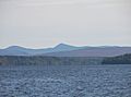
Lac Mégantic, the lake where the Chaudière River begins.
-
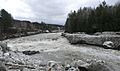
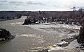
The Grand Sault, a part of the river near Saint-Martin.
-
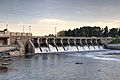
The Sartigan dam in Saint-Georges.
-
A bend in the river at Scott, Quebec.
-
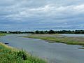
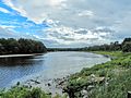
The islands near Saint-Lambert-de-Lauzon.
-
The river when it is flooding in spring.
-
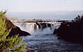
The famous Chaudière Falls.

.jpg)


