
Beaurivage River facts for kids
Quick facts for kids Beaurivage River |
|
|---|---|

The river in Saint-Étienne-de-Lauzon
|
|

|
|
| Native name | Rivière Beaurivage |
| Country | Canada |
| Province | Quebec |
| Administrative region | Chaudière-Appalaches |
| RCM | Robert-Cliche Regional County Municipality, La Nouvelle-Beauce Regional County Municipality, Lotbinière Regional County Municipality, Lévis (a city). |
| Physical characteristics | |
| Main source | Lake Beaurivage Saint-Sévérin 538 metres (1,765 ft) 46°19′06″N 71°04′37″W / 46.31830°N 71.07699°W |
| River mouth | Chaudière River Saint-Sylvestre 70 metres (230 ft) 46°41′33″N 71°16′16″W / 46.69260°N 71.27103°W |
| Length | 65 kilometres (40 mi) |
| Basin features | |
| Progression | Chaudière River, St. Lawrence |
| Basin size | 750 kilometres (466.03 mi) |
| Tributaries |
|
The Beaurivage River is a river in Quebec, Canada. It flows into the Chaudière River, which then flows into the big St. Lawrence River.
The Beaurivage River flows through several towns and areas in Quebec, Canada:
- Saint-Séverin (in the Robert-Cliche area)
- Saint-Elzéar (in the La Nouvelle-Beauce area)
- Saint-Sylvestre, Saint-Patrice-de-Beaurivage, and Saint-Gilles (in the Lotbinière area)
- The city of Lévis
This river is well-known for its yearly canoe race. The race starts in Saint-Patrice-de-Beaurivage, Quebec and ends in Saint-Gilles, Quebec. The town of Saint-Gilles even calls itself the "Capital of the Beaurivage," showing how important the river is to them.
Every spring, the river can flood. This happens when the ice melts. The town of Saint-Étienne-de-Lauzon is often affected, causing roads to close. Luckily, there have been no major accidents reported from these floods.
Contents
About the Beaurivage River
The Beaurivage River starts high up in the Broughton area of Quebec. Its source is near the town of Saint-Séverin. From there, the river flows through many marshy areas. It makes lots of twists and turns, called meanders.
The river is about 65 kilometres (40 mi) long. It drains an area of about 750 kilometres (466.03 mi). This area is called its watershed.
Where the River Flows
As the Beaurivage River continues its journey, it meets other smaller rivers. One of these is the Bras d'Henri, which joins the Beaurivage near Saint-Gilles. After this, the river turns east. It then flows past Saint-Étienne-de-Lauzon. Finally, it joins the Chaudière River just a few kilometers before the Chaudière Falls, near Saint-Rédempteur.
Neighboring Rivers
The Beaurivage River's watershed is surrounded by other important rivers. These include:
- To the north: The Chaudière River and the St. Lawrence River.
- To the east: The Chaudière River, Cugnet River, and Bras d'Henri.
- To the south: The Fourchette River, Saint-André River, Armagh River, Filkars River, and Palmer River.
- To the west: The Noire River, Rouge River, Du Chêne River, and Henri River.
River Name History
The name "Beaurivage" comes from Gilles Rageot, who was given the land (called a seigneury) of Saint-Gilles or Beaurivage in 1738. Many towns and parishes in the area still use the river's name. For example, you'll find places like Saint-Gilles-de-Beaurivage and Saint-Patrice-de-Beaurivage.
The official name "Rivière Beaurivage" was made official on December 5, 1968. This was done by the Commission de toponymie du Québec, which is like a special committee that names places in Quebec.
Images for kids
-
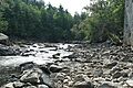
Rapids of the Beaurivage river behind the Gosselin mill in Saint-Étienne-de-Lauzon (Lévis)
-
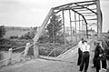
Bridge at Saint-Étienne, 1947.


