
Champlain Canal facts for kids
Quick facts for kids |
|
|
Champlain Canal
|
|

Location in New York

Location in the United States
|
|
| Location | Rensselaer / Saratoga / Washington counties, New York, US; extends from Waterford through Fort Edward to Whitehall |
|---|---|
| Built | 1823 |
| Architect | Wright, Benjamin; Jarvis, John B. |
| Architectural style | Transportation Canal |
| NRHP reference No. | 76001274 |
| Added to NRHP | September 01, 1976 |
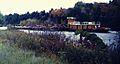
The Champlain Canal is a 60-mile long waterway in New York State. It connects the southern end of Lake Champlain to the Hudson River. This important canal was built at the same time as the famous Erie Canal. Today, it's part of the New York State Canal System and a special route called the Lakes to Locks Passage.
Contents
Building the Champlain Canal
The idea for a canal connecting the Hudson River and Lake Champlain came up in the late 1700s. However, the first plan wasn't approved. A new proposal for the canal was made in 1812. Construction officially began in 1817.
By 1818, about 12 miles of the canal were finished. In 1819, a section of the canal opened from Fort Edward to Lake Champlain. The entire Champlain Canal officially opened on September 10, 1823. It quickly became a big success, carrying lots of goods until the 1970s.
How the Canal Works Today
Today, the Champlain Canal is a great route for people who enjoy boating. It connects the Atlantic Ocean and the Hudson River to Lake Champlain. The canal starts about 3 miles north of the locks at the Troy Federal Dam. This is where the Erie Canal separates from the Hudson River.
The Champlain Canal follows the Hudson River north for about 35 miles. Along this part, there are six special gates called locks. These locks help boats move around dams on the Hudson River. The canal then reaches Lock C-7 in Fort Edward, New York.
From Fort Edward, the canal follows a man-made channel for about 25 miles. This section has five more locks. These locks help bring the canal to the southern end of Lake Champlain at Whitehall, New York.
Changing Water Levels
The water level on the Hudson River part of the canal changes. It goes from about 15 feet above sea level at the southern end to about 130 feet above sea level at Lock C-7. This is where the canal leaves the Hudson River.
The man-made part of the canal reaches its highest point at about 140 feet above sea level. This is between locks C-9 and C-11. After that, the water level goes down to match Lake Champlain. Lake Champlain's water level is usually between 94 and 100 feet above sea level at Whitehall.
Boaters can travel the entire length of Lake Champlain. From there, they can connect to the Chambly Canal. This canal links Lake Champlain to the Saint Lawrence River.
Locks on the Champlain Canal

The Champlain Canal has 11 locks in total. Locks are like water elevators for boats. They help boats move between different water levels. All locks on the New York State Canal System are single-chamber. This means they have one section for boats to enter.
Each lock is 328 feet long and 45 feet wide. They have at least 12 feet of water depth over the gates. This allows them to hold a vessel up to 300 feet long and 43.5 feet wide. The height of the lock walls changes, from 28 feet to 61 feet. This depends on how much the water level needs to change.
There is no Lock C10 on the Champlain Canal. The Troy Federal Lock is just north of Troy, New York. It is not part of the New York State Canal System. The United States Army Corps of Engineers operates it. The Champlain Canal officially starts where the Hudson and Mohawk rivers meet at Waterford, New York.
The table below shows the locks on the current canal, from south to north. The distances and water levels are approximate.
| Lock # | Location | Elevation (upstream/north) |
Elevation (downstream/south) |
Lift or Drop | Distance to Next Lock (upstream/north) |
|---|---|---|---|---|---|
| Troy Federal Lock * | Troy | 15.3 ft (4.7 m) | 1.3 ft (0.4 m) | 14.0 ft (4.3 m) | C1, 5.41 mi (8.71 km) |
| C1 | Waterford | 29.6 ft (9.0 m) | 15.3 ft (4.7 m) | 14.3 ft (4.4 m) | C2, 3.94 mi (6.34 km) |
| C2 | Halfmoon | 48.1 ft (14.7 m) | 29.6 ft (9.0 m) | 18.5 ft (5.6 m) | C3, 2.55 mi (4.10 km) |
| C3 | Mechanicville | 67.6 ft (20.6 m) | 48.1 ft (14.7 m) | 19.5 ft (5.9 m) | C4, 1.84 mi (2.96 km) |
| C4 | Stillwater | 83.6 ft (25.5 m) | 67.6 ft (20.6 m) | 16.0 ft (4.9 m) | C5, 14.41 mi (23.19 km) |
| C5 | Northumberland | 102.6 ft (31.3 m) | 83.6 ft (25.5 m) | 19.0 ft (5.8 m) | C6, 3.73 mi (6.00 km) |
| C6 | Fort Miller | 119.1 ft (36.3 m) | 102.6 ft (31.3 m) | 16.5 ft (5.0 m) | C7, 7.13 mi (11.47 km) |
| C7 | Fort Edward | 129.1 ft (39.3 m) | 119.1 ft (36.3 m) | 10.0 ft (3.0 m) | C8, 2.18 mi (3.51 km) |
| C8 | Fort Edward | 140.1 ft (42.7 m) | 129.1 ft (39.3 m) | 11.0 ft (3.4 m) | C9, 5.83 mi (9.38 km) |
| C9 | Smith's Basin | 124.1 ft (37.8 m) | 140.1 ft (42.7 m) | -16.0 ft (-4.9 m) | C11, 9.24 mi (14.87 km) |
| C11 | Comstock | 112.1 ft (34.2 m) | 124.1 ft (37.8 m) | -12.0 ft (-3.7 m) | C12, 6.44 mi (10.36 km) |
| C12 | Whitehall | 96.6 ft (29.4 m) | 112.1 ft (34.2 m) | -15.5 ft (-4.7 m) | Lake Champlain |
All surface elevations are approximate.
* Denotes Federal managed locks.
Lake Champlain has a water level that usually ranges between 95 feet (29 m) and 100 feet (30.5 m).
Images for kids
-

Perspective map of Mechanicville from the late 19th century, showing the Champlain Canal and Hudson River
-
A tugboat and barge on the Champlain Canal during the 1980s

See also
 In Spanish: Canal Champlain para niños
