Stillwater (village), New York facts for kids
Quick facts for kids
Stillwater
|
|
|---|---|
|
Village
|
|
| Village of Stillwater | |

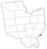
Map highlighting Stillwater's location within Saratoga County.
|
|
| Country | United States |
| State | New York |
| County | Saratoga |
| Incorporation | 1816 |
| Area | |
| • Total | 1.46 sq mi (3.79 km2) |
| • Land | 1.26 sq mi (3.26 km2) |
| • Water | 0.20 sq mi (0.53 km2) |
| Elevation | 92 ft (28 m) |
| Population
(2020)
|
|
| • Total | 1,754 |
| • Density | 1,394.28/sq mi (538.32/km2) |
| Time zone | UTC-5 (Eastern (EST)) |
| • Summer (DST) | UTC-4 (EDT) |
| ZIP code |
12170
|
| Area code(s) | 518 |
| FIPS code | 36-71322 |
| GNIS feature ID | 0966435 |
Stillwater is a small village located in Saratoga County, New York, in the United States. In 2020, about 1,754 people lived here.
It's important to know that there's another place called Stillwater in New York, but it's a different area and not connected to this village. The Village of Stillwater is found in the southeastern part of the larger Town of Stillwater. It is just north of the City of Mechanicville.
History of Stillwater
Stillwater has a long and interesting history. In 1709, a fort called Fort Ingoldsby was built here. This fort was ordered by Peter Schuyler to help protect the area where the village would later grow.
The village officially became a village in 1816. Stillwater is also home to "The Blockhouse," a historic building that was moved here from the Saratoga battlefield. This shows how important the area was in past events.
You can also find other old buildings in Stillwater, like the unique Octagon House. There are also twin houses that were built in the late 1800s. Stillwater was even mentioned in a book called The Angel of Darkness, published in 1997.
Stillwater's Geography
Stillwater is located at coordinates 42°56′24″N 73°39′1″W / 42.94000°N 73.65028°W.
The village covers a total area of about 1.4 square miles (3.7 square kilometers). Most of this area is land, about 1.2 square miles (3.2 square kilometers). The rest, about 0.2 square miles (0.5 square kilometers), is water.
Stillwater is on the west side of the Hudson River. The Hudson River also marks the border with Rensselaer County. A small stream called Schuyler Creek flows into the Hudson River right in the village.
Major roads pass through Stillwater. U.S. Route 4 and New York State Route 32 both go through the village as Hudson Avenue. County Road 76, also known as Lake Road, becomes Lake Street when it enters the village. From the east, Rensselaer County Road 125, which is the Stillwater Bridge Road, ends at the county border.
Population and People
| Historical population | |||
|---|---|---|---|
| Census | Pop. | %± | |
| 1870 | 737 | — | |
| 1880 | 877 | 19.0% | |
| 1890 | 747 | −14.8% | |
| 1900 | 1,007 | 34.8% | |
| 1910 | 1,004 | −0.3% | |
| 1920 | 982 | −2.2% | |
| 1930 | 1,051 | 7.0% | |
| 1940 | 971 | −7.6% | |
| 1950 | 1,276 | 31.4% | |
| 1960 | 1,398 | 9.6% | |
| 1970 | 1,428 | 2.1% | |
| 1980 | 1,572 | 10.1% | |
| 1990 | 1,531 | −2.6% | |
| 2000 | 1,644 | 7.4% | |
| 2010 | 1,738 | 5.7% | |
| 2020 | 1,754 | 0.9% | |
| U.S. Decennial Census | |||
The population of Stillwater has changed over the years. In 2000, there were 1,644 people living in the village. This included 616 households and 450 families.
The village is home to a diverse group of people. Most residents are White, but there are also people of African American, Native American, Asian, and other backgrounds. Some residents are also of Hispanic or Latino heritage.
About 39% of households in 2000 had children under 18 living with them. The average household had about 2.67 people. The average family size was about 3.14 people.
The age of people in the village varies. In 2000, about 29% of the population was under 18 years old. About 12.6% of residents were 65 years or older. The average age in the village was 35 years old.
See also
 In Spanish: Stillwater (villa) para niños
 | Bayard Rustin |
 | Jeannette Carter |
 | Jeremiah A. Brown |


