Rensselaer County, New York facts for kids
Quick facts for kids
Rensselaer County
|
|||
|---|---|---|---|

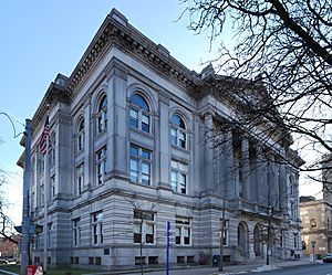
Rensselaer County Courthouse
|
|||
|
|||

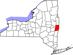
Location within the U.S. state of New York
|
|||
 New York's location within the U.S. |
|||
| Country | |||
| State | |||
| Founded | February 7, 1791 | ||
| Named for | Kiliaen van Rensselaer | ||
| Seat | Troy | ||
| Largest city | Troy | ||
| Area | |||
| • Total | 665 sq mi (1,720 km2) | ||
| • Land | 652 sq mi (1,690 km2) | ||
| • Water | 13 sq mi (30 km2) 1.9% | ||
| Population
(2020)
|
|||
| • Total | 161,133 | ||
| • Density | 247.0/sq mi (95.4/km2) | ||
| Time zone | UTC−5 (Eastern) | ||
| • Summer (DST) | UTC−4 (EDT) | ||
| Congressional districts | 20th, 21st | ||
Rensselaer County is a county in the U.S. state of New York. In 2020, about 161,130 people lived there. Its main city, or county seat, is Troy.
The county is named after Kiliaen van Rensselaer. He was a Dutch merchant who owned much of the land in this area a long time ago. Rensselaer County is part of the Capital District region of New York State. It is also part of the larger city area that includes Albany, Schenectady, and Troy.
Contents
History of Rensselaer County
Long ago, the Mohican Indian tribe lived in the area that is now Rensselaer County. They spoke a language called Algonquian. In 1630, a Dutch jeweler and merchant named Kiliaen van Rensselaer bought this land. He made it part of his large estate, called Rensselaerswyck. At that time, it was part of the Dutch colony of New Netherland.
In 1664, the land became part of English rule. The Dutch took control again in 1673, but the English got it back in 1674. The area stayed under English or British control until 1776, when America became independent.
Rensselaer County was officially created in 1791. It was formed from a very large area that was originally part of Albany County.
How Towns Were Formed
In 1807, some rural parts of Troy became separate towns. The city of Troy was also officially recognized. Two new towns were created: Brunswick and Grafton. Brunswick was named after Duke Friedrich Wilhelm of Braunschweig-Lüneburg. Grafton was named after Henry FitzRoy, 5th Duke of Grafton.
A third town, Philipstown, was created in 1806. In 1808, it was renamed Nassau. This name came from the duke of that area.
Geography and Landscape
Rensselaer County covers about 665 square miles. Most of this (652 square miles) is land, and 13 square miles (about 1.9%) is water. The county is located in the far eastern part of New York State. Its eastern edge touches the borders of Vermont and Massachusetts.
Mountains and Rivers
The land in Rensselaer County changes a lot. Near the Hudson River, it is flat. Then, it rises into the Rensselaer Plateau around towns like Poestenkill and Sand Lake. Further east, along the Massachusetts border, you'll find the Taconic Mountains.
The highest point in the county is Berlin Mountain. It is 2,818 feet (859 meters) above sea level, located in the town of Berlin. The lowest point is 62 feet (19 meters) above sea level, found at the southernmost part of the Hudson River in the county. The Hoosic River, which flows into the Hudson River, is in the northern part of the county.
If you travel by road, New York City is about 132 to 178 miles (212 to 286 kilometers) away from Rensselaer County.
Neighboring Counties
Rensselaer County shares its borders with several other counties:
- Washington County — to the north
- Bennington County, Vermont — to the northeast
- Berkshire County, Massachusetts — to the east
- Columbia County — to the south
- Greene County — to the southwest
- Albany County — to the west
- Saratoga County — to the northwest
Population and People
| Historical population | |||
|---|---|---|---|
| Census | Pop. | %± | |
| 1800 | 30,442 | — | |
| 1810 | 36,309 | 19.3% | |
| 1820 | 40,153 | 10.6% | |
| 1830 | 49,424 | 23.1% | |
| 1840 | 60,259 | 21.9% | |
| 1850 | 73,363 | 21.7% | |
| 1860 | 86,328 | 17.7% | |
| 1870 | 99,549 | 15.3% | |
| 1880 | 115,328 | 15.9% | |
| 1890 | 124,511 | 8.0% | |
| 1900 | 121,697 | −2.3% | |
| 1910 | 122,276 | 0.5% | |
| 1920 | 113,129 | −7.5% | |
| 1930 | 119,781 | 5.9% | |
| 1940 | 121,834 | 1.7% | |
| 1950 | 132,607 | 8.8% | |
| 1960 | 142,585 | 7.5% | |
| 1970 | 152,510 | 7.0% | |
| 1980 | 151,966 | −0.4% | |
| 1990 | 154,429 | 1.6% | |
| 2000 | 152,538 | −1.2% | |
| 2010 | 159,429 | 4.5% | |
| 2020 | 161,130 | 1.1% | |
| U.S. Decennial Census 1790-1960 1900-1990 1990-2000 2010-2020 |
|||
In 2010, there were 159,429 people living in Rensselaer County. There were 62,694 households and 39,989 families. The county had about 233 people per square mile.
Most people in the county (about 88.73%) were White. About 7.14% were Black or African American. Other groups included Asian (1.71%) and Native American (0.23%). About 5.01% of the population was Hispanic or Latino.
Many people had Irish (22.3%), Italian (14.7%), or German (12.8%) backgrounds. Most people (95.4%) spoke English as their first language. About 2.7% spoke Spanish.
Age and Families
About 24.20% of the people in the county were under 18 years old. About 10.10% were between 18 and 24. And 13.60% were 65 years or older. The average age was 37 years.
For every 100 females, there were about 95.90 males. Many households (46.80%) were married couples living together. About 12.00% were female householders without a husband present.
The average income for a household in the county was $42,905. For families, it was $52,864. About 9.50% of all people lived below the poverty line. This included 11.90% of those under 18.
2020 Census Update
| Race | Num. | Perc. |
|---|---|---|
| White (NH) | 124,600 | 77.32% |
| Black or African American (NH) | 11,800 | 7.32% |
| Native American (NH) | 310 | 0.2% |
| Asian (NH) | 5,711 | 3.54% |
| Pacific Islander (NH) | 17 | 0.01% |
| Other/Mixed (NH) | 9,210 | 6% |
| Hispanic or Latino | 9,482 | 6% |
Education in Rensselaer County
Rensselaer County has 16 different school districts. Some of these districts are completely within the county. Others cross into nearby counties. No school districts cross into Vermont or Massachusetts.
School Districts and BOCES
The table below shows the school districts in the county. It also shows which BOCES they belong to. BOCES are organizations that help school districts share services. The table also lists other counties these districts might serve.
| District | BOCES | Other counties district serves |
|---|---|---|
| Averill Park Central School District | Questar III | None |
| Berlin Central School District | Questar III | None |
| Brunswick (Brittonkill) Central School District | Questar III | None |
| Cambridge Central School District | WSWHE BOCES | Washington County |
| East Greenbush Central School District | Questar III | Columbia County |
| Hoosic Valley Central School District | Questar III | Washington County |
| Hoosick Falls Central School District | N/A | Washington County |
| Ichabod Crane Central School District | Questar III | Columbia County |
| Lansingburgh Central School District | Questar III | None |
| Mechanicville City School District | WSWHE BOCES | Saratoga County |
| New Lebanon Central School District | Questar III | Columbia County |
| North Greenbush Common School District | Questar III | None |
| Rensselaer City School District | Questar III | None |
| Schodack Central School District | Questar III | Columbia County |
| Troy City School District | Capital Region Boces | None |
| Wynantskill Union Free School District | Questar III | None |
The Doane Stuart School is a private school for both boys and girls in Rensselaer County. The county is also home to Rensselaer Polytechnic Institute. This is the oldest technology college in America.
Communities in Rensselaer County
Rensselaer County has several different types of communities.
Cities
- Rensselaer
- Troy (This is the county seat, or main city.)
Towns
Villages
Census-Designated Places (CDPs)
These are areas that are like towns but are not officially incorporated as cities or villages.
- Averill Park
- East Greenbush
- Hampton Manor
- Nassau Lake
- Poestenkill
- West Sand Lake
- Wynantskill
Hamlets
Hamlets are small communities, often without their own local government.
See also
 In Spanish: Condado de Rensselaer para niños
 | Misty Copeland |
 | Raven Wilkinson |
 | Debra Austin |
 | Aesha Ash |


