Schaghticoke (village), New York facts for kids
Quick facts for kids
Schaghticoke, New York
|
|
|---|---|
|
Village
|
|

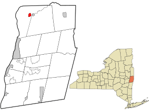
Location in Rensselaer County and the state of New York.
|
|

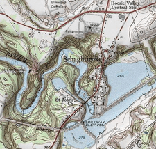
USGS topographical map with the village
|
|
| Country | United States |
| State | New York |
| County | Rensselaer |
| Area | |
| • Total | 0.99 sq mi (2.57 km2) |
| • Land | 0.76 sq mi (1.96 km2) |
| • Water | 0.23 sq mi (0.61 km2) |
| Elevation | 358 ft (109 m) |
| Population
(2020)
|
|
| • Total | 527 |
| • Density | 695.25/sq mi (268.40/km2) |
| Time zone | UTC-5 (Eastern (EST)) |
| • Summer (DST) | UTC-4 (EDT) |
| ZIP code |
12154
|
| Area code(s) | 518 |
| FIPS code | 36-65475 |
| GNIS feature ID | 0964566 |
Schaghticoke is a small village located in Rensselaer County, New York, United States. In 2020, about 527 people lived there.
This village is part of the larger Town of Schaghticoke. It is found near the eastern edge of the town, just west of the Village of Valley Falls.
Before European settlers arrived, this area was home to different groups of Native Americans. Between 1640 and 1750, Mohicans and other tribes from New England lived here.
Contents
History of Schaghticoke Village
Early Native American Settlements
In the past, the area around Schaghticoke was an important home for Native American groups. These included the local Mohicans and people from other tribes. Many of these tribes had moved west from New England. They were trying to escape conflicts and new settlements by Europeans.
Some of these tribes were the Abenaki, Wampanoag, and Narraganset. Their way of life had been greatly changed by wars with the English, like King Philip's War.
This mixed group of Native Americans was very strong in the area from about 1640 to 1750. They sometimes had as many as 1,000 men. Even though they respected the Iroquois to the west, they controlled their own land here.
European Settlement and Land Changes
By 1750, most of the land had been sold to European settlers. The last of the Schaghticoke Native American group moved north. They wanted to avoid more European settlement. After they left, the Iroquois claimed the remaining land.
In 1769, settlers paid 5,000 pieces of Spanish Gold for the area. This land was known as the Kaydeross Patent.
Village Name Changes
When European Americans first settled here, they called the village "Harts Falls." It became an official village under that name in 1867. Later, in 1881, its name was changed to "Schaghticoke."
Geography of Schaghticoke
Schaghticoke is located at specific coordinates: 42.899551 degrees North and -73.586128 degrees West.
The village is right next to the Hoosic River. This river is an important natural feature of the area.
According to the United States Census Bureau, the village covers about 0.9 square miles (2.3 square kilometers). Most of this area, about 0.7 square miles (1.9 square kilometers), is land. The rest, about 0.2 square miles (0.4 square kilometers), is water. This means that about 18.89% of the village's total area is water.
Population and People
| Historical population | |||
|---|---|---|---|
| Census | Pop. | %± | |
| 1890 | 1,258 | — | |
| 1900 | 1,061 | −15.7% | |
| 1910 | 765 | −27.9% | |
| 1920 | 568 | −25.8% | |
| 1930 | 555 | −2.3% | |
| 1940 | 603 | 8.6% | |
| 1950 | 687 | 13.9% | |
| 1960 | 720 | 4.8% | |
| 1970 | 860 | 19.4% | |
| 1980 | 677 | −21.3% | |
| 1990 | 794 | 17.3% | |
| 2000 | 676 | −14.9% | |
| 2010 | 592 | −12.4% | |
| 2020 | 527 | −11.0% | |
| U.S. Decennial Census | |||
In the year 2000, there were 676 people living in Schaghticoke. These people lived in 270 households. About 181 of these households were families.
The population density was about 916 people per square mile. There were 284 housing units in the village.
Most of the people in the village were White (96.30%). A smaller number were Black or African American (1.48%), Native American (0.59%), or Asian (0.59%). Some people (1.04%) were from two or more races. About 0.59% of the population was Hispanic or Latino.
Households and Families
Out of the 270 households, about 34.4% had children under 18 living there. About 50.4% were married couples living together. About 11.9% were households led by a female without a husband present. About 32.6% were not families.
About 25.9% of all households had only one person living there. About 10.4% had someone living alone who was 65 years old or older. The average household had 2.50 people. The average family had 3.03 people.
Age Distribution
The population in the village was spread out by age:
- 26.2% were under 18 years old.
- 9.5% were from 18 to 24 years old.
- 32.0% were from 25 to 44 years old.
- 20.6% were from 45 to 64 years old.
- 11.8% were 65 years old or older.
The average age in the village was 36 years. For every 100 females, there were about 96.5 males. This ratio was similar for those aged 18 and over.
Income Information
In 2000, the average income for a household in the village was $37,417. For families, the average income was $44,432.
Men had an average income of $36,510. Women had an average income of $26,667. The average income per person in the village was $17,734.
About 7.4% of families and 8.3% of the total population lived below the poverty line. This included 8.6% of those under 18 and 12.5% of those aged 65 or older.
See also
 In Spanish: Schaghticoke (villa) para niños
 | Frances Mary Albrier |
 | Whitney Young |
 | Muhammad Ali |


