Schodack, New York facts for kids
Quick facts for kids
Schodack
|
|
|---|---|

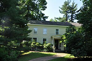
Blink Bonnie, Shodack, NY
|
|

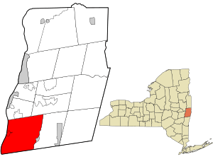
Location in Rensselaer County and the state of New York.
|
|
| Country | United States |
| State | New York |
| County | Rensselaer |
| Area | |
| • Total | 63.60 sq mi (164.73 km2) |
| • Land | 61.93 sq mi (160.39 km2) |
| • Water | 1.68 sq mi (4.34 km2) |
| Elevation | 308 ft (94 m) |
| Population
(2020)
|
|
| • Total | 12,965 |
| • Density | 203.852/sq mi (78.705/km2) |
| Time zone | UTC-5 (Eastern (EST)) |
| • Summer (DST) | UTC-4 (EDT) |
| ZIP code |
12156
|
| Area code(s) | 518 and 838 |
| FIPS code | 36-65541 |
| GNIS feature ID | 0979469 |
| Website | www.schodack.org |
Schodack is a town in Rensselaer County, New York. It is located in the southwestern part of the county. Schodack is southeast of Albany, the capital city of New York.
In 2020, about 12,965 people lived in Schodack. The town's name comes from "Escotak," a word from the Mahican tribe. It means "fireplace of the nation."
Contents
History of Schodack
Before Europeans arrived, the Mahican tribe lived in this area. Their main village, "Esquatak," was very important to them. In 1609, explorer Henry Hudson partly explored this region.
European settlers first came to Schodack in the 1600s. It was part of the Manor of Rensselaerswyck. This was a large area in the New Netherland colony, which was controlled by the Dutch.
The town of Schodack was officially created in 1795. This happened when the large Rensselaerwyck area was divided. Later, in 1896, some parts of Schodack were given to the nearby towns of Nassau and Berlin.
Several historic places in Schodack are listed on the National Register of Historic Places. These include Blink Bonnie, Elmbrook Farm, the Muitzes Kill Historic District, and the Joachim Staats House and Gerrit Staats Ruin.
Geography and Location
Schodack covers about 63.7 square miles (164.7 square kilometers). Most of this area is land, with a small part being water. It is the third largest town in Rensselaer County by area.
The western border of Schodack is the Hudson River. Across the river is Albany County. The southern border of the town touches Columbia County.
Major roads pass through Schodack. These include the New York State Thruway, Interstate 90, US Route 9, and US Route 20.
Schodack is surrounded by other towns. To the north is East Greenbush. To the south are Stuyvesant and Kinderhook in Columbia County. Nassau is to the east. Across the Hudson River to the west is Coeymans in Albany County.
Population and People
| Historical population | |||
|---|---|---|---|
| Census | Pop. | %± | |
| 1820 | 3,493 | — | |
| 1830 | 3,795 | 8.6% | |
| 1840 | 4,125 | 8.7% | |
| 1850 | 3,510 | −14.9% | |
| 1860 | 3,993 | 13.8% | |
| 1870 | 4,442 | 11.2% | |
| 1880 | 4,319 | −2.8% | |
| 1890 | 4,338 | 0.4% | |
| 1900 | 4,334 | −0.1% | |
| 1910 | 4,780 | 10.3% | |
| 1920 | 3,992 | −16.5% | |
| 1930 | 4,639 | 16.2% | |
| 1940 | 5,081 | 9.5% | |
| 1950 | 6,164 | 21.3% | |
| 1960 | 8,052 | 30.6% | |
| 1970 | 11,196 | 39.0% | |
| 1980 | 11,345 | 1.3% | |
| 1990 | 11,839 | 4.4% | |
| 2000 | 12,536 | 5.9% | |
| 2010 | 12,794 | 2.1% | |
| 2020 | 12,965 | 1.3% | |
| U.S. Decennial Census | |||
In 2000, there were 12,536 people living in Schodack. There were 4,737 households, which are groups of people living together. About 3,500 of these were families.
The population density was about 201 people per square mile (77.8 per square kilometer). Most of the people living in Schodack were White (97.54%).
About 35.2% of households had children under 18 living with them. Many households (61.0%) were married couples. The average household had 2.62 people. The average family had 3.04 people.
The median age in the town was 39 years old. This means half the people were younger than 39 and half were older. About 26.0% of the population was under 18 years old.
The median income for a household in Schodack was $55,176. For families, the median income was $63,622.
Education in Schodack
Most students in Schodack attend schools in the Schodack Central School District. This district has three schools:
- Maple Hill High School
- Maple Hill Middle School
- Castleton Elementary School (located in the nearby village of Castleton)
A small part of Schodack is in the East Greenbush Central School District. Green Meadow Elementary School is located near Schodack Center. Another small area on the southern border of Schodack is served by the Ichabod Crane Central School District.
Notable People from Schodack
Some well-known people have connections to Schodack:
- Elizabeth Jessup Eames (1813-1856) – A writer.
- George McClellan – A former US Congressman.
- Jaime Schultz – A Major League Baseball pitcher who played for the Tampa Bay Rays and Los Angeles Dodgers.
Communities and Places in Schodack
Schodack has several smaller communities and interesting places:
- Braeside – A small community (hamlet) on the west side of Nassau Lake.
- Brookview – A hamlet northeast of Castleton-on-Hudson.
- Castleton-on-Hudson – A village located by the Hudson River in the southwestern part of the town.
- East Schodack – A hamlet in the northeastern part of the town, once called Scotts Corners.
- Lower Schodack Island – An island in the Hudson River, close to Schodack Landing.
- Morey Park – A hamlet on the north side of Nassau Lake, near the eastern town line.
- Muitzeskill – A hamlet east of Schodack Landing, named after a local stream. The Muitzes Kill Historic District is a historic area here.
- Nassau Lake – A lake on the eastern town line.
- Rice Corners – A hamlet east of Schodack Center.
- Rosecrans Park – A hamlet south of Nassau Lake.
- Schodack Center – A hamlet near the middle of the town, located on Routes 9 and 20.
- Schodack Landing – A hamlet by the Hudson River in the southwestern part of the town. The Schodack Landing Historic District is a historic area here.
- Schodack Island State Park – A state park in the southwestern part of the town, great for outdoor activities.
- Shivers Corners – A hamlet north of East Schodack.
- South Schodack – A hamlet north of Van Hoesen Station.
- Stony Point – A hamlet near the Hudson River in the western part of the town.
- Van Hoesen Station – A hamlet located where South Schodack Road and Van Hoesen Road meet, along the Boston-Albany rail line.
See also
 In Spanish: Schodack para niños
 | Victor J. Glover |
 | Yvonne Cagle |
 | Jeanette Epps |
 | Bernard A. Harris Jr. |

