Pittstown, New York facts for kids
Quick facts for kids
Pittstown, New York
|
|
|---|---|

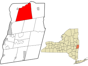
Location in Rensselaer County and the state of New York.
|
|
| Country | United States |
| State | New York |
| County | Rensselaer |
| Area | |
| • Total | 64.84 sq mi (167.94 km2) |
| • Land | 61.63 sq mi (159.62 km2) |
| • Water | 3.22 sq mi (8.33 km2) |
| Elevation | 679 ft (207 m) |
| Population
(2020)
|
|
| • Total | 5,540 |
| • Density | 85.44/sq mi (32.988/km2) |
| Time zone | UTC-5 (Eastern (EST)) |
| • Summer (DST) | UTC-4 (EDT) |
| FIPS code | 36-58398 |
| GNIS feature ID | 0979373 |
Pittstown is a town located in Rensselaer County, New York, in the United States. In 2020, about 5,540 people lived there. It's found in the northern part of the county.
Pittstown shares a small border with Washington County, New York to the north. The Hoosic River forms part of its northwestern edge. Other towns nearby include Schaghticoke to the west, Brunswick to the southwest, Grafton to the southeast, and Hoosick to the east.
Most of the town is served by the Hoosic Valley Central School District. The southern part of Pittstown is part of the Brunswick (Brittonkill) Central School District. A small area in the eastern part of the town is served by the Hoosick Falls Central School District.
Contents
History of Pittstown
Pittstown is one of the very first towns created in Rensselaer County. It was officially formed in 1788. Its history dates back to a land grant from 1761.
Some important historical places in Pittstown are listed on the National Register of Historic Places. These include the Coletti–Rowland–Agan Farmstead, the Howard–Odmin–Sherman Farmstead, and the Tomhannock Methodist Episcopal Church. These buildings help us remember the past of the area.
Geography and Nature
Rivers and Reservoirs
New York State Route 67 follows the Hoosic River, which forms the northeastern border of Pittstown.
In the western part of the town, there is a large man-made lake called the Tomhannock Reservoir. This reservoir is very important because it supplies drinking water to the people living in the city of Troy.
Forests and Land Area
The Pittstown State Forest is located in the southeastern corner of the town. New York State Route 7 runs along the northern edge of the Rensselaer Plateau in this area.
The United States Census Bureau reports that Pittstown covers a total area of about 64.8 square miles (167.9 square kilometers). Most of this area, about 61.7 square miles (159.6 square kilometers), is land. The remaining 3.1 square miles (8.3 square kilometers) is water, mainly from the Tomhannock Reservoir and parts of the Hoosic River.
Population Over Time
| Historical population | |||
|---|---|---|---|
| Census | Pop. | %± | |
| 1820 | 3,772 | — | |
| 1830 | 3,702 | −1.9% | |
| 1840 | 3,784 | 2.2% | |
| 1850 | 3,732 | −1.4% | |
| 1860 | 3,826 | 2.5% | |
| 1870 | 4,093 | 7.0% | |
| 1880 | 4,095 | 0.0% | |
| 1890 | 4,056 | −1.0% | |
| 1900 | 3,236 | −20.2% | |
| 1910 | 2,920 | −9.8% | |
| 1920 | 2,342 | −19.8% | |
| 1930 | 2,426 | 3.6% | |
| 1940 | 2,491 | 2.7% | |
| 1950 | 2,666 | 7.0% | |
| 1960 | 2,973 | 11.5% | |
| 1970 | 3,905 | 31.3% | |
| 1980 | 4,901 | 25.5% | |
| 1990 | 5,468 | 11.6% | |
| 2000 | 5,644 | 3.2% | |
| 2010 | 5,735 | 1.6% | |
| 2020 | 5,540 | −3.4% | |
| U.S. Decennial Census | |||
The population of Pittstown has changed quite a bit over the years. In 1820, there were 3,772 people living here. The population grew steadily through the 1800s, reaching over 4,000 people.
However, in the early 1900s, the population started to decrease. By 1920, it was down to 2,342 people. After that, the number of residents began to rise again. By 2010, Pittstown had 5,735 people. The most recent count in 2020 showed the population was 5,540.
Communities and Places
Pittstown is home to several smaller communities and interesting locations:
- Boyntonville – A small community located near the eastern border of the town, along Route 7.
- East Pittstown – Another small community found in the northeastern part of the town, close to the town line.
- Factory Hollow – A small community.
- Johnsonville – A community in the northern part of the town, right by the Hoosic River. A bridge was built here across the river in 1825.
- Little Red Schoolhouse – A community located southeast of Valley Falls.
- Millertown – A community in the northern part of the town, east of Valley Falls. It was also known as "North Pittstown" in the past.
- Raymertown – A community in the southwestern part of the town, on Route 7. It is southwest of the Tomhannock Reservoir. This community was named after the local Raymer family.
- Tomhannock – A community located northeast of the Tomhannock Reservoir. It used to be called "Reeds Hollow."
- Tomhannock Reservoir – A large reservoir that provides water to the city of Troy. It is in the southwestern part of the town.
- Valley Falls – This is a small village located in the northwestern part of Pittstown.
- Redemption Christian Academy – A private Christian school located within the town.
See also
 In Spanish: Pittstown (Nueva York) para niños
 | Selma Burke |
 | Pauline Powell Burns |
 | Frederick J. Brown |
 | Robert Blackburn |

