Stephentown, New York facts for kids
Quick facts for kids
Stephentown, New York
|
|
|---|---|

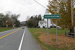
Entering Stephentown
|
|

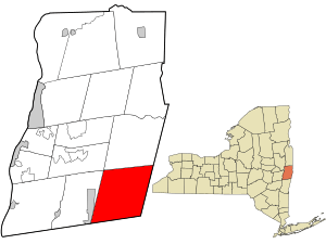
Location in Rensselaer County and the state of New York.
|
|
| Country | United States |
| State | New York |
| County | Rensselaer |
| Area | |
| • Total | 58.09 sq mi (150.44 km2) |
| • Land | 57.89 sq mi (149.93 km2) |
| • Water | 0.20 sq mi (0.51 km2) |
| Elevation | 1,063 ft (324 m) |
| Population
(2020)
|
|
| • Total | 2,791 |
| Time zone | UTC-5 (Eastern (EST)) |
| • Summer (DST) | UTC-4 (EDT) |
| ZIP codes |
12168-12169
|
| Area code(s) | 518 |
| FIPS code | 36-71102 |
| GNIS feature ID | 0979523 |
Stephentown is a small town in Rensselaer County, New York, United States. In 2020, about 2,791 people lived there.
The town was first called Jericho Hallow. It was part of the Massachusetts Bay Colony. Later, it was renamed after Stephen Van Rensselaer. Stephentown is special because it's the only place with this name on Earth!
Contents
History of Stephentown
Stephentown was first settled around 1765. The town officially started in 1788. It was formed from a part of the Rensselaerwyck District. The first settlers in Stephentown came from New England. Most of them were from Rhode Island and Connecticut.
Geography of Stephentown
Stephentown covers about 58.1 square miles (150.4 square kilometers). Most of this area is land. Only a tiny part, about 0.1 square miles (0.26 square kilometers), is water.
The southern border of the town touches Columbia County, New York. To the east, Stephentown shares a border with Massachusetts. The western and central parts of the town are on the Rensselaer Plateau. This is a high, flat area.
Population and People
| Historical population | |||
|---|---|---|---|
| Census | Pop. | %± | |
| 1820 | 2,592 | — | |
| 1830 | 2,716 | 4.8% | |
| 1840 | 2,753 | 1.4% | |
| 1850 | 2,622 | −4.8% | |
| 1860 | 2,311 | −11.9% | |
| 1870 | 2,133 | −7.7% | |
| 1880 | 1,986 | −6.9% | |
| 1890 | 1,764 | −11.2% | |
| 1900 | 1,545 | −12.4% | |
| 1910 | 1,289 | −16.6% | |
| 1920 | 1,109 | −14.0% | |
| 1930 | 1,093 | −1.4% | |
| 1940 | 1,181 | 8.1% | |
| 1950 | 1,295 | 9.7% | |
| 1960 | 1,361 | 5.1% | |
| 1970 | 1,731 | 27.2% | |
| 1980 | 2,031 | 17.3% | |
| 1990 | 2,521 | 24.1% | |
| 2000 | 2,873 | 14.0% | |
| 2010 | 2,903 | 1.0% | |
| 2020 | 2,791 | −3.9% | |
| U.S. Decennial Census | |||
In 2010, there were 2,903 people living in Stephentown. There were 1,141 households, which are groups of people living together. Most of the people living in Stephentown are White (96.7%). A small number are African American, Native American, or Asian. About 3.11% of the population was Hispanic or Latino.
About 35.5% of households had children under 18 living with them. The average household had about 2.54 people. The average family had about 2.94 people. The median age in the town was 38 years old. This means half the people were younger than 38, and half were older.
Communities and Locations in Stephentown
Stephentown has several smaller communities and places:
- Cherry Plain State Park – A small part of this state park is in the northern area of the town.
- East Nassau – The eastern part of East Nassau village is on the western edge of Stephentown.
- Garfield – A small community located southwest of Stephentown village.
- North Stephentown – A community found near the northern town line, along Route 22.
- Stephentown – This is the main community, located in the eastern part of the town.
- Stephentown Center – A community northwest of Stephentown village. It used to be called "Mechanicville."
- Stephentown Flats – This was once a community south of Stephentown village.
- West Stephentown – A community located near the western town line.
- Wyomanock – A community south of Stephentown village, also on Route 22.
Famous People from Stephentown
Many interesting people have come from Stephentown:
- Smith A. Boughton – A leader during the Anti-Rent War.
- Ezra S. Carr – A professor from California.
- Solomon C. Carr – A politician and farmer in Wisconsin.
- Roy Face – A famous Major League Baseball relief pitcher. He played for the Pittsburgh Pirates.
- Brian Holloway – A professional National Football League player.
- David Holloway – Another professional National Football League player.
- Amaziah B. James – A Judge and Congressman from New York.
- Hosea Moffitt – A Congressman from New York.
- Zadock Pratt – Also a Congressman from New York.
- Darius Quimby – The first peace officer in the United States to die while on duty.
Electric Power in Stephentown
What is the Stephentown Spindle?
Stephentown has a special power facility called the Stephentown Spindle. It uses flywheel technology to store energy. It was built in 2010.
How Does it Work?
The facility has 200 giant flywheels. Each flywheel weighs 5 tons! These flywheels spin very fast, from 8,000 to 16,000 rotations per minute. When they spin, they store energy as rotational energy. This stored energy can then be released back into the power grid.
The Stephentown Spindle helps keep the electricity grid stable. It is the first commercial flywheel project in the United States. It helps manage the power supply by providing "frequency regulation service." This means it helps keep the electricity flowing smoothly.
See also
 In Spanish: Stephentown para niños
 | Stephanie Wilson |
 | Charles Bolden |
 | Ronald McNair |
 | Frederick D. Gregory |

