Halfmoon, New York facts for kids
Quick facts for kids
Halfmoon
|
||
|---|---|---|
| Town of Halfmoon | ||

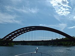
The Thaddeus Kosciusko Bridge connects Halfmoon in Saratoga County to Colonie in Albany County, New York, over the Mohawk River.
|
||
|
||

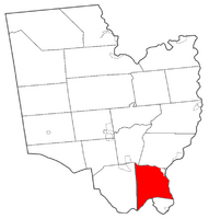
Location within Saratoga County
|
||
| Country | United States | |
| State | New York | |
| County | Saratoga | |
| Settled | 1788 | |
| Named for | Halve Maen | |
| Area | ||
| • Total | 33.63 sq mi (87.10 km2) | |
| • Land | 32.58 sq mi (84.38 km2) | |
| • Water | 1.05 sq mi (2.72 km2) | |
| Elevation | 282 ft (86 m) | |
| Population
(2020)
|
||
| • Total | 25,662 | |
| • Density | 787.66/sq mi (304.12/km2) | |
| Time zone | UTC-5 (Eastern (EST)) | |
| • Summer (DST) | UTC-4 (EDT) | |
| ZIP code |
12065 & 12118
|
|
| Area code(s) | 518 | |
| FIPS code | 36-31489 | |
| GNIS feature ID | 0979035 | |
Halfmoon is a town located in Saratoga County, New York, in the United States. In 2020, about 25,662 people lived there. The town might be named because of the half-moon shape of the land where the Hudson and Mohawk Rivers meet. Another idea is that it was named after Henry Hudson's ship, the Halve Maen. Halfmoon is in the southeastern part of Saratoga County, just north of Albany.
Contents
A Look at Halfmoon's Past
The first settlements in the Halfmoon area began around 1680. These early communities were located near the Mohawk River.
How Halfmoon Became a Town
Halfmoon officially became a town in 1788. At that time, it was part of Albany County. For a short time in 1816, its name was changed to Orange. This happened when the town of Waterford was created from a part of Halfmoon. However, the original name, Halfmoon, was brought back in 1820. Later, in 1828, the western part of Halfmoon was used to create another new town, called Clifton Park.
The Erie Canal's Impact
The famous Erie Canal was built along the southern edge of Halfmoon. This important waterway followed part of the Mohawk River. The canal helped transport goods and people across New York State.
Exploring Halfmoon's Geography
Halfmoon covers an area of about 33.7 square miles (87.1 square kilometers). Most of this area, about 32.7 square miles (84.38 square kilometers), is land. The rest, about 1.0 square mile (2.72 square kilometers), is water.
Rivers and Borders
The southern border of Halfmoon is formed by the Mohawk River. This river also marks the edge of Albany County. To the east, the town's border is the Hudson River, which separates Halfmoon from Rensselaer County. The northern border of Halfmoon is defined by the Anthony Kill. This is a smaller stream that flows into the Hudson River.
Major Roads and Highways
Several important roads run through or near Halfmoon:
- Interstate 87: Also known as the Adirondack Northway, this large six-lane highway runs north and south along the western side of Halfmoon.
- U.S. Route 9: This road runs parallel to Interstate 87, a bit further east. It enters Halfmoon from Albany County using the Crescent Bridge.
- New York State Route 146: This east-west highway meets U.S. Route 9 in the small community (or hamlet) called Clifton Park.
- U.S. Route 4: This north-south highway is found in the eastern part of the town.
- New York State Route 236: This is a shorter state highway that connects NY-146 to US-9.
Halfmoon's Population Over Time
| Historical population | |||
|---|---|---|---|
| Census | Pop. | %± | |
| 1820 | 4,024 | — | |
| 1830 | 2,042 | −49.3% | |
| 1840 | 2,631 | 28.8% | |
| 1850 | 2,788 | 6.0% | |
| 1860 | 3,130 | 12.3% | |
| 1870 | 3,093 | −1.2% | |
| 1880 | 3,102 | 0.3% | |
| 1890 | 3,732 | 20.3% | |
| 1900 | 5,101 | 36.7% | |
| 1910 | 5,980 | 17.2% | |
| 1920 | 1,534 | −74.3% | |
| 1930 | 1,739 | 13.4% | |
| 1940 | 1,969 | 13.2% | |
| 1950 | 2,836 | 44.0% | |
| 1960 | 4,120 | 45.3% | |
| 1970 | 9,287 | 125.4% | |
| 1980 | 11,860 | 27.7% | |
| 1990 | 13,879 | 17.0% | |
| 2000 | 18,474 | 33.1% | |
| 2010 | 21,535 | 16.6% | |
| 2020 | 25,662 | 19.2% | |
|
|
|||
In 2000, there were 18,474 people living in Halfmoon. These people lived in 7,778 households. About 30.3% of these households had children under 18 living with them. The average household had 2.35 people. The average family had 2.93 people.
The population was spread out by age. About 23.7% of the people were under 18 years old. About 10.6% were 65 years or older. The average age in the town was 36 years old.
People from Halfmoon
Some notable people who have lived in Halfmoon include:
- Chauncey Boughton: A doctor and a member of the New York State Assembly.
- Daniel G. Garnsey: A former member of the U.S. Congress.
Schools in Halfmoon
Students in Halfmoon attend schools in three different school districts:
- Mechanicville City School District
- Shenendehowa Central School District
- Waterford-Halfmoon Union Free School District
Communities and Places in Halfmoon
Halfmoon is made up of several smaller communities and locations:
- Coons – A small community (hamlet) located near the northern border of the town. It is west of Mechanicville.
- Crescent – A hamlet found in the southern part of Halfmoon.
- Halfmoon (formerly called “Middletown”) – This is the main hamlet of Halfmoon. It is in the southern part of the town where several county roads meet.
- Halfmoon Beach – A hamlet located along the riverbank in the southwestern corner of the town.
- Grays Corners – A specific location in the southwestern part of Halfmoon.
- Newtown – A hamlet in the northeastern part of the town, located on NY-146.
- Smithtown – This was a community that used to exist south of Newtown.
See also
 In Spanish: Halfmoon (Nueva York) para niños
 | Emma Amos |
 | Edward Mitchell Bannister |
 | Larry D. Alexander |
 | Ernie Barnes |


