
Monteregian Hills facts for kids
Quick facts for kids Monteregian Hills |
|
|---|---|

Three of the central Monteregian hills (from left: Mont Saint-Hilaire, Mont Rougemont and Mont Yamaska) viewed from space.
|
|
| Highest point | |
| Peak | Mont Megantic |
| Elevation | 1,105 m (3,625 ft) |
| Geography | |
| Country | Canada |
| Province | Quebec |
| Range coordinates | 45°28.7′N 73°2.4′W / 45.4783°N 73.0400°W |
| Geology | |
| Age of rock | Early Cretaceous |
The Monteregian Hills (which means Collines Montérégiennes in French) are a line of hills found in Montreal and the Montérégie region of Quebec, Canada. They are located between the Laurentians and the Appalachians. These hills are special because they stand alone, not connected to larger mountain ranges.
How They Got Their Name
The name "Monteregian Hills" was first used in 1903 by a geologist named Frank Dawson Adams from Montreal. He noticed that Mount Royal (which means Mons Regius in Latin) and other hills nearby had similar rock types. He called them the "Royal Mountains."
At first, this group included hills like Mont Saint-Bruno, Mont Saint-Hilaire, Mont Saint-Grégoire, Mont Rougemont, Mont Yamaska, Mont Shefford, and Mont Brome. Later, Mont Mégantic, the Oka Hills, and other formations were added to the list.
The Story of Their Rocks
Each of the Monteregian Hills is made of very old, hard rock that was pushed up from deep inside the Earth. This rock is called igneous rock, and it's much tougher than the softer sedimentary rock around it. Because it's so strong, it has resisted weathering (the process of breaking down rocks) over millions of years.
These hills are part of something called the Great Meteor hotspot track. Imagine the Earth's surface (the North American Plate) slowly sliding over a very hot spot deep inside the Earth. This hot spot created a trail of melted rock that pushed upwards. The Monteregian Hills are what's left of these pushes. Scientists think these rocks were either the "feeders" for volcanoes that were active about 125 million years ago, or they were simply intrusions that never quite broke through to the surface as volcanoes.
The tops of these hills have thin, rocky soil, and most of them are covered in forests. Some areas have soil that is good for growing apples, especially on the lower slopes where cold air can easily drain away.
| Name | Height | Age | Coordinates | Location |
|---|---|---|---|---|
| St. Andrews formation | 130 metres (430 ft) | n/a | 45°55"N, 74°31'W | Saint-André-d'Argenteuil |
| Oka Hills | 249 metres (817 ft) | n/a | 45°28'N, 74°5'W | Oka |
| Mount Royal | 233 metres (764 ft) | 118-138 myr | 45°30'23"N, 73°35'20"W | Montreal |
| Mont Saint-Bruno | 218 metres (715 ft) | 118-136 myr | 45°33'1"N, 73°19'09"W | Saint-Bruno-de-Montarville |
| Mont Saint-Hilaire | 411 metres (1,348 ft) | 135 myr | 45°33'8"N, 73°9'3"W | Mont-Saint-Hilaire |
| Mont Saint-Grégoire | 251 metres (823 ft) | 119 myr | 45°21'29"N, 73°09'08"W | Mont-Saint-Grégoire |
| Mont Rougemont | 381 metres (1,250 ft) | 137 myr | 45°28'36"N, 73°03'17"W | Rougemont |
| Mont Yamaska | 416 metres (1,365 ft) | 120-140 myr | 45°27'25"N, 72°52'19"W | Saint-Paul-d'Abbotsford |
| Mont Shefford | 526 metres (1,726 ft) | 120-130 myr | 45°21'49"N, 72°37'33"W | Shefford |
| Mont Brome | 553 metres (1,814 ft) | 118-138 myr | 45°16'59"N, 72°37'59"W | Bromont |
| Mont Mégantic | 1,105 metres (3,625 ft) | 128-133 myr | 45°27'20.5"N, 71°9'7.6"W | Notre-Dame-des-Bois |
Gallery
-
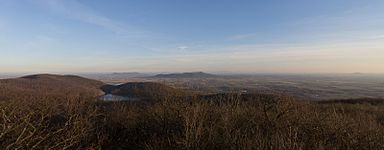
Four of the Monteregian Hills in the late fall
-
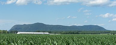
Mont Saint-Hilaire from the south
-
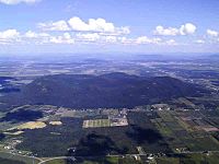
aerial view of Mont Yamaska
-
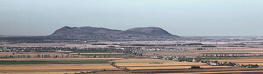
Mont Rougemont as seen from Mt. Saint-Grégoire
-
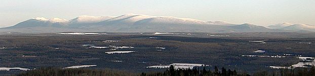
Mont Mégantic as seen from the Stoke Mountains


See also
 In Spanish: Colinas de Montérégie para niños
