
Mount Royal facts for kids
Quick facts for kids Mount Royal |
|
|---|---|

Mount Royal's eastern slope.
|
|
| Highest point | |
| Elevation | 233 m (764 ft) |
| Naming | |
| Native name | Error {{native name}}: an IETF language tag as parameter {{{1}}} is required (help) |
| Geography | |

Mount Royal
Location in Quebec
|
|
| Parent range | Monteregian Hills |
| Topo map | NTS 31H |
| Geology | |
| Age of rock | Early Cretaceous |
| Mountain type | Intrusive stock |
| Climbing | |
| First ascent | Jacques Cartier, 1535 (first European) |
| Easiest route | Hiking or Cycling |
Mount Royal (French: Mont Royal) is a large hill or small mountain located in Montreal, Quebec, Canada. It sits just west of Downtown Montreal. The city of Montreal actually got its name from Mount Royal!
This hill is part of the Monteregian Hills, a chain of mountains found between the Laurentians and the Appalachian Mountains. Mount Royal itself has three main peaks:
- Colline de la Croix (also called Mont Royal proper) is the tallest at 233 meters (764 feet).
- Colline d'Outremont (or Mount Murray) is 211 meters (692 feet) high.
- Westmount Summit reaches 201 meters (659 feet) above sea level.
Contents
How Mount Royal Was Formed: Geology

Mount Royal is not an extinct volcano, even though some guidebooks might say so. Instead, it's the deep part of a very old volcanic system that has worn away over millions of years. About 125 million years ago, hot, melted rock (called magma) pushed up from deep inside the Earth. This magma cooled and hardened underground. It never actually erupted as lava onto the surface.
The mountain, along with other hills in the Monteregian Hills chain, formed when the North American Plate moved west. As it moved, magma pushed into the softer sedimentary rocks below the surface. This process is called intrusion. The main rock type found here is gabbro, which is a hard, dark rock. Over time, the softer rocks around the hardened magma wore away due to erosion, leaving behind the tough igneous rock that makes up Mount Royal today.
A special mineral, montroyalite, was discovered in Montreal and is named after this mountain.
History of Mount Royal

The first European to climb Mount Royal was Jacques Cartier in 1535. Local people from the village of Hochelaga guided him. Cartier named the mountain "Mount Royal" in honor of his patron, John Royal. In his journal, he wrote about the town of Hochelaga being near a mountain, which he then named Mount Royal.
There are different ideas about how the Island of Montréal got its name. One idea is that it comes from Mont Réal, which was how the mountain's name was spelled in older French. Another idea is that a map from 1556 used the Italian name "Monte Real" for the mountain, and this name was later used for the island and then the city.
In 1643, Paul de Chomedey, Sieur de Maisonneuve, who founded Montreal, made a special trip to the top of the mountain. He did this to keep a promise he made after a big flood threatened the town.
Later, in the early 1900s, a large housing area called Northmount Heights was built on the western side of the mountain. Today, much of this area is part of the Université de Montréal.
Between 1914 and 1918, the Mount Royal Tunnel was dug under the mountain. This tunnel is still used today by commuter trains.
Mount Royal Park was even considered as a possible location for Expo 67, a big world's fair, but the fairgrounds were eventually built on islands in the Saint Lawrence River. For the 1976 Summer Olympics, the park hosted the cycling road race event.
Exploring Mount Royal Park

Mount Royal Park (known as Parc du Mont-Royal in French) is one of Montreal's largest green spaces. It was designed by Frederick Law Olmsted, who also helped design New York City's Central Park. The park officially opened in 1876.
Olmsted wanted to make the mountain's height seem even bigger using different types of plants. However, due to money problems in the 1870s, many of his detailed plans for planting were not followed.
The park has two main viewpoints, called belvederes. The most famous one is the Kondiaronk Belvedere, which is a curved plaza with the Mount Royal Chalet. From here, you get an amazing view of Downtown Montreal. This viewpoint was built in 1906 and is named after Kondiaronk, a First Nations chief who helped bring peace in 1701.
Other fun things to find in the park include Beaver Lake (a small artificial lake), areas for snow tubing and tobogganing in winter, and trails for cross-country skiing. There's also a sculpture garden and Smith House, which is a visitor center. At the bottom of the hill, near Park Avenue, you'll find the George-Étienne Cartier Monument and a bandstand named after writer Mordecai Richler.
The park's beautiful forest has faced challenges, including a severe Ice Storm of 1998, but it has mostly recovered. It's known for its stunning autumn foliage and its many hiking and cross-country ski trails. Biking is allowed on the main gravel roads.
From 1885 to 1920, a special train called the Mount Royal Funicular Railway took visitors to the top. After it stopped running, a streetcar line brought people up until 1959. Today, a road named after former mayor Camillien Houde goes through the mountain.
The park, along with nearby cemeteries and other areas, is now part of the Mount Royal Natural and Historical District. This protects the area's important cultural and natural heritage.
Parc Tiohtià:ke Otsira’kéhne
In June 2017, during Montreal's 375th birthday, the green area around the Outremont peak was officially named Parc Tiohtià:ke Otsira’kéhne. This is a Mohawk name that means "the place of the big fire." It reminds us that First Nations people used the hill for fire beacons long ago.
Winter Fun on Mount Royal


Mount Royal Park is a great place for winter activities! You can go snow tubing and tobogganing on old ski slopes. There are also 7 groomed trails for cross-country skiing and snowshoeing, totaling 18 kilometers (11 miles). You can even rent equipment right there.
One of the most popular winter activities is ice skating on Beaver Lake. It's free if you bring your own skates!
In the past, Mount Royal had alpine ski slopes with a T-bar lift. Mechanical lifts were first put in the park in 1945. In the 1920s, one of the best ski jumps in Canada was on Mount Royal, near Côte-des-Neiges.
The Montreal Snow Shoe Club, founded in 1840, used to meet weekly in winter for torchlit snowshoe trips through Mount Royal Park. Members started wearing blue tuques (winter hats) around 1870. This tradition has recently been brought back as the Tuques Bleues celebration.
Tam-Tams: A Summer Tradition

In the summer, Mount Royal hosts a popular event called Tam-Tams, or the "Tam-Tam Jam." On Sunday afternoons, many Montrealers and visitors gather on the eastern slope of the mountain, near the George-Étienne Cartier Monument. They play hand drums like djembes, creating a lively atmosphere. People from all walks of life come together, and often, dozens of drummers play at once, encouraging others to dance. You might also see people having friendly battles with foam-padded weapons nearby!
The Tam-tams started in the late 1970s. It's not officially organized by the city, but the city now helps manage the event. They make sure commercial activities are registered and have police and first aid staff on hand for safety.
Jeanne-Mance Park
Across Park Avenue from the mountain is Jeanne-Mance Park. This is another popular spot for fun activities. Jeanne-Mance Park has a playground, a wading pool, tennis courts, and various sports fields. In winter, it even has a skating rink.
Mount Royal Cross

The first Mount Royal Cross was placed on the mountain in 1643 by Paul Chomedey de Maisonneuve, the founder of Montreal. He put it there to keep a promise he made to the Virgin Mary after praying for a disastrous flood to stop.
Today, a large, illuminated cross stands on top of the mountain. It is 31.4 meters (103 feet) tall and was put there in 1924. The city now owns it. The cross used to be lit with fiber-optic lights and then with LEDs in 2009. It's usually lit in white, but its color can be changed for special occasions, like purple when a pope passes away.
Next to the cross, there's a plaque marking a time capsule placed in 1992. This was during Montreal's 350th birthday celebration. The capsule holds messages and drawings from 12,000 children, showing their hopes for the city in the year 2142, when it is planned to be opened.
Mount Royal's Transmission Tower

Mount Royal is also home to a facility for the CBC. This includes two large buildings and a relatively short, 100-meter (328 feet) tall tower. Almost all of Montreal's television and FM radio stations broadcast from this tower.
The tower's height is limited to 1100 feet (about 335 meters) above sea level by the government. This is because it's close to the flight path for Trudeau Airport. Engineers had to design the "candelabra" shape to fit all the necessary antennas in the limited space.
Nearby Landmarks


Beyond the park, Mount Royal's slopes are home to many other important Montreal landmarks. These include Saint Joseph's Oratory, which is Canada's largest church, and McGill University. You'll also find the Montreal General Hospital, McGill's Molson Stadium (home to the CFL's Montreal Alouettes), and the Université de Montréal. Some wealthy neighborhoods like Upper Westmount and Upper Outremont are also located on the mountain's slopes.
Images for kids
-
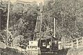
Mount Royal Funicular Railway, around 1900.

See also
 In Spanish: Monte Royal para niños
