Hochelaga (village) facts for kids
Quick facts for kids
Hochelaga
|
|
|---|---|
|
Village
|
|
 |
|
| Country | Canada |
| Province | Quebec |
| Region | Montreal |
| Established | ? |
| Dissolved | 16th century |
| Highest elevation | 233 m (764 ft) |
| Lowest elevation | 6 m (20 ft) |
| Time zone | UTC−5 (EST) |
| • Summer (DST) | UTC−4 (EDT) |
| Official name: Hochelaga National Historic Site of Canada | |
| Designated: | 1920 |
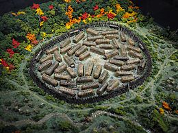
Hochelaga was a fortified village that existed in the 1500s. It was home to the St. Lawrence Iroquoians people. The village was located near Mount Royal in what is now Montreal, Quebec, Canada.
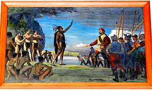
The French explorer Jacques Cartier arrived by boat on October 2, 1535. He visited the village the next day. The Iroquoians welcomed him kindly. Cartier named the nearby mountain Mount Royal. Many names around Montreal today come from his visit.
A stone marker was placed in 1925 to remember the village. It is near McGill University. This spot is thought to be close to where Cartier visited. The marker site is a National Historic Site of Canada.
The name Hochelaga is still used today. It is part of Hochelaga-Maisonneuve, a neighbourhood in Montreal. A similar spelling, Osheaga, is used for a music festival in Montreal.
Contents
What Does Hochelaga Mean?
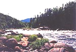
Most language experts believe Hochelaga is a French version of an Iroquois word. It might come from osekare, meaning "beaver path" or "beaver dam". It could also be from osheaga, meaning "big rapids". This refers to the nearby Lachine Rapids.
Another idea is that osheaga means "people of the shaking hands". Some stories say the Iroquoian people were confused by Cartier waving his hands. Others say they were confused by his European custom of shaking hands. These ideas are popular with the Mohawk people further downriver. However, the Mohawk language is quite different from the Laurentian language spoken at Hochelaga.
Where Was Hochelaga Located?
Our main information about Hochelaga comes from a book by Jacques Cartier. It's called Bref récit. Cartier gave this book to King Francis I of France in 1545.
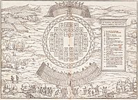
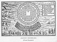
A map titled La Terra de Hochelaga nella Nova Francia shows Cartier's visit. Giacomo Gastaldi drew this map. It was part of a larger work published in Venice between 1550 and 1556. The map shows houses in perfect rows. It also shows boards covering the village's fence. These details were likely added by Gastaldi. They probably don't show how the village really looked.
The village was surrounded by a wooden fence. It had about fifty houses. Most were longhouses, made of wood and bark. About 3,000 people lived there.
Hochelaga was likely destroyed later. Cartier did not mention it when he returned in 1541. He spoke of two villages, but only named one, Tutonaguy. Wars, perhaps with Stadacona, might have caused Hochelaga to disappear.
Why Did Hochelaga Disappear?
Many ideas explain why the people of Hochelaga disappeared. They might have moved west towards the Great Lakes. Wars with other Iroquois tribes or the Hurons could have happened. Diseases brought by Europeans might also be a reason.
However, some experts think the main reason was land exhaustion. The people might have moved when the land could no longer support them. When Samuel de Champlain arrived later, neither the Algonquins nor the Mohawks had permanent settlements there. They hunted and raided in the Saint Lawrence Valley.
Moving villages was a common practice. This might be why Hochelaga's exact location is still a mystery. Many theories try to place it near Mount Royal.
William Douw Lighthall thought Hochelaga was at the Dawson site. This site was found in 1860 near McGill University. It seems to be an older village, without a fence, and too small. Another idea is Outremont, north of the mountain. This would make sense if Cartier came by the Rivière des Prairies.
Some suggest the village was on the summit of Mount Royal. But Cartier clearly said the mountain was "adjacent to their said village." He also said Hochelaga was "close to and adjoining a mountain." He walked a quarter-league to Mount Royal. This distance matches the basin of Mount Royal from the hills around it. Recent digs on the mountain have found nothing. The exact spot of Hochelaga is still unknown.
European Explorers Visit
Jacques Cartier's Arrival
Jacques Cartier arrived in Hochelaga in 1535. This event was very important for the history of New France. Cartier was on his second trip to the West Indies. King Francis I had sent him to find a water route to Cathay (China) and Cipango (Japan).
Cartier reached Stadacona (now Québec City) in late summer 1535. He continued inland, but rapids near the Island of Montreal blocked his way. He then visited Hochelaga. He wrote about it in Bref récit. In 1611, explorer Samuel de Champlain visited the area.
In 1642, the village of Ville-Marie was founded. This was done by Paul de Chomedey, sieur de Maisonneuve. But people slowly started calling it Montreal instead. This name came from mont royal, the French name for Mount Royal.
Entering by the Rivière des Prairies
For a long time, people thought Cartier always followed the Saint Lawrence River. The rapids he mentioned were thought to be the Lachine Rapids. But some believe his description fits the rapids in the Rivière des Prairies better. These are at Sault-au-Récollet.
Studies in the 1900s suggested that before Europeans arrived, the Rivière des Prairies was often used by Indigenous tribes. It was safer than the Saint Lawrence River with its rapids. It also led more directly to the Rivière des Outaouais. So, Cartier might have reached Hochelaga using this river.
Also, Cartier described three rapids on a later trip. These are easier to find on the Rivière des Prairies. This river is sometimes called the "river of three saults." Aristide Beaugrand-Champagne, an architect, wrote a lot about this idea.
Venice's Interest in Hochelaga
Jacques Cartier's trips to the West Indies caught the attention of people in Venice. One important person was Giovanni Battista Ramusio. He was a statesman and secretary. Ramusio was seven years old when Christopher Columbus reached the Americas in 1492. He thought discovering new lands was very important.
Venice had a big problem getting goods from the Indian Subcontinent. This was because the Ottoman Turks had taken Constantinople in 1453. Ramusio got a copy of Bref récit, Cartier's report to King Francis I. He then wrote about Cartier's explorations in his own book, Delle navigationi et viaggi.
The 1556 edition of Ramusio's book included maps by Giacomo Gastaldi. One map, La Terra de Hochelaga Nella Nova Francia, shows Cartier's visit to Mount Royal (called Monte Real on the map). It shows the scene in the European style of that time.
Hochelaga in Art and Film
One painting in the Mount Royal Chalet is a copy of La Terra de Hochelaga. It was painted by Paul-Émile Borduas.
The movie Hochelaga, Land of Souls (2017) shows Cartier's arrival at Hochelaga. It also tells fictional stories that happen at the village site over many centuries.
 | Delilah Pierce |
 | Gordon Parks |
 | Augusta Savage |
 | Charles Ethan Porter |


