Fort Sainte Thérèse facts for kids
Quick facts for kids Fort Saint Thérèse |
|
|---|---|
| Carignan, Quebec | |

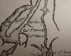
Map of Fort Sainte Thérèse and other forts on the Richelieu River circa 1665 for the campagne of the Regiment of Carignan-Salières
|
|
| Coordinates | 45°23′21″N 73°15′27″W / 45.389111°N 73.257515°W |
| Type | Fort |
| Site information | |
| Controlled by | New France; Canada |
| Official name: Fort Ste. Thérèse National Historic Site of Canada | |
| Designated: | 1923 |
| Site history | |
| Built | 1665 |
| In use | 1665–1760 |
Fort Sainte Thérèse is the name for three different forts. They were built one after the other in the same spot. These forts were part of a group of strongholds built by France in the 1600s. They were located along the Richelieu River in Quebec, Canada.
Contents
History of the Forts
The First Fort (1665–1667)
The first fort was built in October 1665. It was put up by Henri de Chastelard de Salières. He was an officer from the Carignan-Salières Regiment. The fort was finished on October 15. This date was the religious anniversary of sainte Thérèse.
The fort's location was very important. It was at the end of the Sainte-Thérèse rapids. This made it a great spot to control the river. However, this first Fort Sainte Thérèse was left empty in 1667.
The Second Fort (1747–1760)
In 1731, the governor of New France was worried. He was concerned about the Iroquois people and the English colonies to the south. So, he ordered new forts to be built along the Richelieu River. This led to forts like Pointe-à-la-Chevelure and Saint-Frédéric.
A road was also built between Chambly and the old Fort Sainte Thérèse site. In 1741 and 1742, a large building was put up at Sainte Thérèse. It was used to store the King's boats.
Because of threats from the English, a new fort was built at Sainte Thérèse in 1747. Commander Vassant was in charge of this. But the fort was left empty the next year. Efforts were then focused on Fort Saint-Jean further south.
What was left of Fort Sainte-Thérèse was used to store goods. This was during the British invasion from 1756 to 1759. But in 1760, Major Robert Rogers and his soldiers burned it down.
The Third Fort (1760)
During the British attack on Montreal in the summer of 1760, French and Canadian soldiers went to Fort Sainte Thérèse. The fort was already burned. In September, the French left it after losing a battle at île aux Noix.
The English then took over the fort's location. They dug trenches all around it. This spot was used as a meeting point for their troops. They gathered there before capturing Fort Chambly on September 4, 1760.
After the British Took Over
The British used the fort's location as an English Post. Their troops made the road between Sainte Thérèse and Chambly better. This road was later extended to Saint-Jean in 1776. This happened during the American Revolution. However, the fort's buildings were in ruins. People soon forgot where it was.
Finding the Fort Again
The building of the Chambly Canal from 1831 to 1843 made the fort's site harder to reach. In 1923, the site was named a National Historic Site of Canada. In 1927, a stone and plaque were put up for Fort Ste. Thérèse. But its exact location was still a mystery.
For a long time, no one was sure where the fort really was. But around the year 2000, a historian named Réal Fortin worked with Parks Canada. They thought the fort was on the south side of Point Portage. Their findings were shared in 2003. Fortin believed the fort was on lot 343 in Carignan. This was on the west side of the Richelieu River.
Then, in November 2007, something amazing was found. It was an aerial photo taken in 1938. This photo clearly showed the outline of the fort's western side! This proved the fort was a bit south of where the 1927 plaque said.
Archaeological digs started in the spring of 2008. They continued in August 2009 and May 2010. The fort's location was confirmed. Many things were found, like the outlines of all three forts. They also found parts of the fort's walls and fences. The dig site was open to the public. People could watch the archaeologists work.
The site is now part of the Chambly Canal National Historic Site. It is managed by Parks Canada.
 | Jessica Watkins |
 | Robert Henry Lawrence Jr. |
 | Mae Jemison |
 | Sian Proctor |
 | Guion Bluford |

