
Cumberland Gap facts for kids
Quick facts for kids Cumberland Gap |
|
|---|---|

Cumberland Gap in winter
|
|
| Elevation | 1,631 ft (497 m) |
| Traversed by | |
| Location | |
| Range | Cumberland Mountains |
| Coordinates | 36°36′15″N 83°40′25″W / 36.6041°N 83.6737°W |
| Topo map | USGS Middlesboro South |

Location in the United States

Location in Virginia

Location in Kentucky
|
|
The Cumberland Gap is a famous mountain pass in the eastern United States. It cuts through the long Cumberland Mountains, which are part of the larger Appalachian Mountains. It's located where the states of Kentucky, Virginia, and Tennessee meet.
This pass is about 1,631 feet (497 meters) high. It became very important in early American history as a main path for settlers moving west.

Native American groups used the gap for a long time. In 1750, Thomas Walker, a doctor and explorer from Virginia, showed it to settlers. Later, a team of frontiersmen led by Daniel Boone made the path wider. This helped many pioneers travel into the western areas of Kentucky and Tennessee. The gap was a key part of the Wilderness Road. Today, it is part of the Cumberland Gap National Historical Park.
Contents
What is the Cumberland Gap?
The Cumberland Gap is a unique pass in the Appalachian Mountains. It is the only one that goes through the continuous ridgeline of the Cumberland Mountain range. The gap is inside Cumberland Gap National Historical Park. It sits on the border of Kentucky and Virginia. It is also very close to where those two states meet Tennessee.
The gap looks like a "V" shape and acts as a natural gateway to the west. The lowest part of the gap is about 300 feet (91 meters) above the valley floor. The north side of the pass was made 20 feet (6 meters) lower when Old U.S. Route 25E was built. To the south, the ridge rises 600 feet (183 meters) above the pass. To the north, the Pinnacle Overlook is 900 feet (274 meters) higher, at 2,505 feet (764 meters) tall.
The area around Cumberland Gap has all four seasons. Summers are usually sunny, warm, and humid, with temperatures around 80-85°F (29-32°C). Winters, from January to March, are generally mild. Temperatures are usually in the 30s-40s°F (0s°C), with rain and some snow.
The closest cities are Middlesboro, Kentucky, and Harrogate, Tennessee. The nearby town of Cumberland Gap, Tennessee, is named after the pass.
How was the Cumberland Gap formed?

The Cumberland Gap was formed by several big geological events. These include the Pine Mountain Thrust Sheet, the Middlesboro Syncline, and the Rocky Face Fault. Millions of years ago, strong forces pushed layers of rock deep within the Earth upwards. This created the Pine Mountain Thrust Sheet.
Later, a huge meteorite, about the size of a football field, hit the Earth less than 300 million years ago. This created the Middlesboro Crater. The city of Middlesboro, Kentucky, is built entirely inside this crater. Scientists found special rock patterns called shatter cones in the area. These patterns only form when a meteorite hits. This discovery helped prove that a meteorite impact created the crater.
The combination of these natural processes, including the Rocky Face Fault, made the gap easier to travel through. Without these events, it would have been very hard for people and wagons to pass through. Middlesboro is also the only place in the world where coal is mined inside a meteorite crater.
History of the Cumberland Gap
The first written record of the Cumberland Gap was in the 1670s by Abraham Wood of Virginia. The gap was named after Prince William, Duke of Cumberland, who was the son of King George II of Great Britain. Many places in the American colonies were named after him.

In 1775, Daniel Boone and his team were hired by the Transylvania Colony to widen the path through the gap. This made it easier for settlers to move into Kentucky and Tennessee. By the 1790s, the path Boone built was wide enough for wagons and became known as the Wilderness Road.

The Cumberland Gap was also important during the American Civil War. In June 1862, Union Army General George W. Morgan captured the gap for the Union. Later, in September 1862, Confederate States Army forces took control of it. In September 1863, Union troops under General Ambrose Burnside forced the Confederates to surrender the gap without a fight. The Union then controlled the gap for the rest of the war.

It's believed that between 200,000 and 300,000 European-American settlers passed through the gap before 1810. Today, about 18,000 cars drive through the area daily. Around 1.2 million people visit the park each year. The park has many hiking trails for visitors to enjoy.

U.S. Route 25E used to go over the gap. But in 1996, the Cumberland Gap Tunnel was finished. Now, cars go through the tunnel, and the original trail over the gap has been restored.
Historic District
The Cumberland Gap and its historical sites were added to the National Register of Historic Places on May 28, 1980. This means they are protected as an important part of history.
Plants and Animals
Plants
The Cumberland Gap National Historical Park is home to many different plants. So far, 855 types of vascular plants have been found there. This number is expected to grow as more studies are done. The park has 15 different types of plant communities. Some of these are in special places like mountain bogs, low wetlands, and rocky cliffs.
Animals
As of 2014, 371 animal species have been listed in the park. This includes:
- 33 types of mammals
- 89 types of birds
- 29 types of amphibians
- 15 types of reptiles
- 27 types of fish
- 187 types of insects
Visitors might see gray squirrels, white-tailed deer, cottontail rabbits, songbirds, hawks, snakes, and turtles. If you are lucky, you might even spot a black bear or a bobcat. Over 120 bird species have been recorded in the park.
In Popular Culture
The Cumberland Gap has been mentioned in many songs. It is even the title of several popular folk songs, including:
- "Cumberland Gap" (first recorded in 1924) is a famous folk song. It has been sung by American musicians like Woody Guthrie and Earl Scruggs. British artists like Lonnie Donegan also performed it.
- "Cumberland Gap" by the American band Ragged Mountain String Band.
- "Cumberland Gap" by Jason Isbell and the 400 Unit.
- "Cumberland Gap" by David Rawlings on his 2017 album Poor David's Almanack.
- "Mighty Joe Moon" by Grant Lee Buffalo on their album Mighty Joe Moon.
- "Wagon Wheel" by Old Crow Medicine Show.
- "Wagon Wheel" by Darius Rucker. Rucker's version reached number 1 on the Hot Country Songs chart.
Images for kids
-
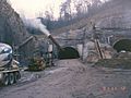
Construction of the Cumberland Gap Tunnel in 1991
-
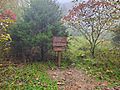
The saddle of Cumberland Gap along the Wilderness Road
-

Vice President Richard Nixon at the Pinnacle Interpretive Shelter during his visit to Cumberland Gap National Historical Park in July 1959.


.jpg)
See also
 In Spanish: Desfiladero de Cumberland para niños
