Cumberland Gap National Historical Park facts for kids
Quick facts for kids |
|
|
Cumberland Gap National Historical Park
|
|
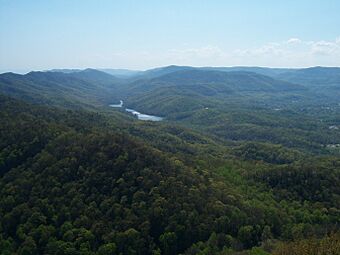
View from the Pinnacle Overlook toward the southwest, overlooking Fern Lake and the surrounding park, 2009
|
|
 |
|
| Location | Kentucky, Tennessee, and Virginia, United States |
|---|---|
| Nearest city | Cumberland Gap, Tennessee |
| Area | 20,508 acres (8,299 ha) |
| Visitation | 704,598 (2019) |
| NRHP reference No. | 66000353 |
| Added to NRHP | October 15, 1966 |
The Cumberland Gap National Historical Park is a special place in the United States. It's a National Historical Park that sits right where three states meet: Kentucky, Tennessee, and Virginia. This park is built around the Cumberland Gap, which is a natural break in the Appalachian Mountains.
The park covers parts of Bell and Harlan counties in Kentucky. It also includes parts of Claiborne County in Tennessee and Lee County in Virginia. You can even find the exact spot where Kentucky, Virginia, and Tennessee all meet, called a tripoint, by following a trail.
The small town of Cumberland Gap, Tennessee, is actually located inside the park's area.
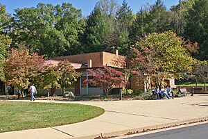
The Cumberland Gap Visitor Center is a great place to start your visit. It's found on U.S. Highway 25E, near the city of Middlesboro, Kentucky. The center has a museum with fun, interactive exhibits. These exhibits show how the Gap was a super important path for travel long ago. There's also an auditorium where you can watch films about the area's history and nature. Plus, you can find books and crafts from the Appalachia region in the gift shop.
Contents
Exploring Cumberland Gap National Historical Park
This park is huge, covering about 24,000 acres! It's one of the biggest national parks in the eastern United States. A large part of it, about 14,091 acres, is set aside as a "Recommended Wilderness" area. This means it's kept as natural as possible.
The park stretches for about 20 miles along the Cumberland Mountains. It's about 1.6 miles wide on average. It crosses over land in Kentucky, Tennessee, and Virginia. The park includes the famous Wilderness Road, which goes through the Cumberland Gap. This gap was a vital natural pathway for both Native Americans and early American settlers.
Caves and Cliffs in the Park
Cumberland Gap National Historical Park is home to 24 known caves. These caves vary in size, from small ones about 20 feet long to a massive one that's over 16 miles long!
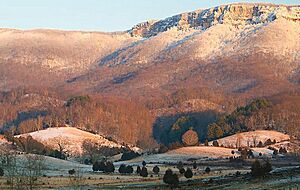
You'll also find impressive cliffs here. The most striking are the White Rocks cliffs, which are about 500 feet tall. They are located in the eastern part of the park.
Weather in the Park
The weather in the park is generally mild. Summers are warm and humid, while winters are not too cold. The average temperature throughout the year is about 54 degrees Fahrenheit.
Waterways and Streams
The park has more than 62 miles of streams flowing through it. Most of these streams start right inside the park. Streams on the north side of the main ridge flow into the Cumberland River. Those on the south side flow into the Powell River. The water quality in the park is mostly good.
Plants and Animals of the Park
The park is mostly covered by forests, about 97% of its area. It's a home for many different kinds of plants, with 970 species of vascular plants. About 90 of these are considered rare or sensitive. However, there are also 108 types of non-native plants, and 31 of these are invasive, meaning they can harm the native plants.
The park is also a haven for animals. You can find at least 145 species of birds here. There are also 40 types of mammals, including the near-threatened Indiana bat. The streams in the park have about 27 species of fish. One of these, the blackside dace, is an endangered species. Plus, at least 36 types of reptiles and amphibians live in the park.
Sometimes, non-native insects can threaten the park's ecosystems. These include pests like the southern pine beetle and the hemlock woolly adelgid. Other insects, like the emerald ash borer and the gypsy moth, are also a concern from nearby areas.
History of the Park

People started thinking about creating a national park here as early as 1922. Business leaders from Middlesboro, Kentucky, suggested a "Lincoln National Park." However, early attempts to make this happen didn't work out.
In 1938, the National Park Service agreed to support a park if the land was donated. This led to the creation of the Cumberland Gap National Historical Park Association. Finally, a bill passed in Virginia in 1939, which helped get federal approval.
The park was officially created on June 11, 1940, by President Franklin Roosevelt. Its purpose was to "commemorate the story of the first doorway of the west." Congress allowed the park to be up to 50,000 acres. The surrounding states bought the land and gave it to the federal government in 1955. The park officially opened to the public in 1959.
In 1992, the park bought the land around Gap Cave, which used to be privately owned. By 1996, many improvements had been made to the park, including the building of the Cumberland Gap Tunnel.
Fern Lake is located at the southern end of the park. It was created by a dam in 1890 and provides water to the nearby town of Middlesboro, Kentucky. The park has been buying the land around Fern Lake in stages. This has increased the park's total size by 20%.
Things to Do and See
The park's visitor center was updated in 2004. It has a museum and an auditorium. Here, you can learn about the area's history and nature. There are also shops where you can buy books and gifts.
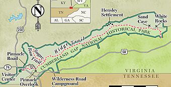
You can take guided tours of the Hensley Settlement and Gap Cave from the visitor center. About 3.5 miles from the center, along Skyland Road, is the Pinnacle Overlook. From this spot, which is 2,440 feet high, you can see amazing views of the gap and the surrounding countryside.
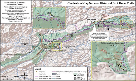
The park offers 85 miles of hiking trails. Some are short, like the 2.6-mile Sugar Run Trail. Others are long, like the 21-mile Ridge Trail, which goes across the entire park and reaches a height of 3,513 feet. There's also the Wilderness Road Campground with 160 campsites. Please remember that hunting is not allowed in the park.
Tri-State Peak is another interesting spot in the park. You can reach it by trail. At the peak, there's a special marker that shows the exact point where Kentucky, Tennessee, and Virginia meet.
Park Visitors
In 2017, the park welcomed 737,547 visitors. A study in 2013 showed that visitors spent about $46 million in nearby towns. This spending helped support 639 local jobs. Most people visit the park during spring, summer, and fall.
Awards and Recognition
In 2017, the park received the Keeper of the Light Award. This award from the National Park Service recognizes excellent educational programs. In 2016, the United States Mint released a special quarter honoring the park. It was part of the America the Beautiful series.
More to Explore
 | Dorothy Vaughan |
 | Charles Henry Turner |
 | Hildrus Poindexter |
 | Henry Cecil McBay |


