
Tri-State Peak facts for kids
Quick facts for kids Tri-State Peak |
|
|---|---|

The summit of Tri-State Peak
|
|
| Highest point | |
| Elevation | 1,990 ft (610 m) |
| Geography | |
| Location | Cumberland Gap National Historical Park, Bell County, Kentucky, Claiborne County, Tennessee, and Lee County, Virginia, United States |
| Parent range | Cumberland Mountains |
| Climbing | |
| Easiest route | Tri-State Peak Trail |
Tri-State Peak is a special mountain located in the Cumberland Gap National Historical Park. It gets its name because it sits exactly where three states meet! These states are Kentucky, Tennessee, and Virginia. Imagine standing in three different states all at the same time – that's what you can do here!
Contents
What is Tri-State Peak?
Tri-State Peak is a unique spot in the United States. It's not just a mountain; it's a place where history and geography come together. People visit to see the exact point where the borders of Kentucky, Tennessee, and Virginia meet.
Where is it Located?
This peak is found within the beautiful Cumberland Gap National Historical Park. This park is famous for its natural beauty and its important role in American history. The peak is near a famous "saddle" in the mountains, which is like a low dip between two higher points.
How High is it?
The highest point at the tri-state marker is about 1,990 feet (or 607 meters) above sea level. That's almost as tall as two Eiffel Towers stacked on top of each other! It's a great spot to get a view of the surrounding area.
Exploring the Peak
Visiting Tri-State Peak is a fun adventure. There's a special path called the "Tri-State Peak Trail" that leads right to the marker. It's about 1.2 miles (or 1.9 kilometers) from the park's visitor center. You can connect to this trail from other paths like the Gap Trail and the Object Lesson Road Trail.
The Tri-State Marker
At the very top of the peak, you'll find a special marker. This marker clearly shows the exact spot where Kentucky, Tennessee, and Virginia meet. It's a popular place for visitors to take photos and celebrate being in three states at once!
The Royal Colonial Boundary
Besides the tri-state marker, there's another interesting marker at the site. This one points out that the location was part of the "Royal Colonial Boundary of 1665." This boundary was an important line drawn a very long time ago, in 1665, when America was still a group of colonies ruled by England. The American Society of Civil Engineers helped mark this historical spot. It reminds us of the early days of America and how land was divided.
Images for kids
-
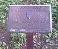
Royal Colonial Boundary of 1665 plaque
-
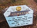
Marker for Tennessee at Tri-State Peak
-
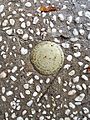
Marker for the KY-TN-VA tripoint


