Lee County, Virginia facts for kids
Quick facts for kids
Lee County
|
|
|---|---|
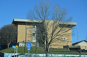
Lee County Courthouse in Jonesville
|
|
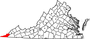
Location within the U.S. state of Virginia
|
|
 Virginia's location within the U.S. |
|
| Country | |
| State | |
| Founded | October 25, 1792 |
| Named for | Light Horse Harry Lee |
| Seat | Jonesville |
| Largest town | Pennington Gap |
| Area | |
| • Total | 437 sq mi (1,130 km2) |
| • Land | 436 sq mi (1,130 km2) |
| • Water | 1.9 sq mi (5 km2) 0.4% |
| Population
(2020)
|
|
| • Total | 22,173 |
| Time zone | UTC−5 (Eastern) |
| • Summer (DST) | UTC−4 (EDT) |
| Congressional district | 9th |
Lee County is the county farthest to the west in Virginia. In 2020, about 22,173 people lived there. The main town and government center is Jonesville.
Contents
History of Lee County
The area of western Virginia and eastern Kentucky was once home to many Native American groups during ancient times. The first Europeans known to visit what is now Lee County were Spanish explorers in 1540. They were sent by Hernando de Soto to look for gold.
Lee County was created in 1792 from Russell County. It was named after Light Horse Harry Lee. He was the Governor of Virginia from 1791 to 1794. Lee was famous for leading light cavalry during the American Revolutionary War. He was also the father of Robert E. Lee, who later became a general during the American Civil War.
Lee County was an important stop on the Wilderness Road. This famous path was used by settlers heading west into Kentucky. During the 1780s and 1790s, people built strong, fortified buildings called "stations" along the trail. These stations offered protection from Native American raids. Settlers followed Daniel Boone's path.
Some of the stations in Lee County included Yoakum Station (near Dryden), Rocky Station, Mump's Fort (at Jonesville), Prist Station, Martin's Station (at Rose Hill), Chadwell Station, Owen Station (at Ewing), and Gibson Station.
One of the biggest landowners in the early days was Joseph Martin. He was an officer in the Revolutionary War and an explorer. Martin's Station and Martin's Creek are named after him. He received a large land grant of about 25,000 acres (100 km²) after the war. He then sold parts of this land. Rose Hill became the first official post office in Lee County in 1832. Later, parts of Lee County were used to form Scott County in 1814 and Wise County in 1856.
Economy and Tourism
For a long time, the economy of Lee County mainly depended on growing tobacco and mining coal. However, as these industries declined, many people lost their jobs. This also caused the population to decrease since 1940.
To help the economy, Lee County now tries to attract visitors through "heritage tourism." This means they highlight the county's history and its role in the journey west. The county uses the slogan Where Virginia Begins.
Lee County shares Cumberland Gap National Historical Park with Kentucky and Tennessee. This park is a major attraction. Some cool places to visit in the park include Hensley's Settlement, the Pinnacle Overlook, the Sand Cave, and the White Rocks. These rocks offer great views of the towns of Ewing and Rose Hill.
Geography of Lee County
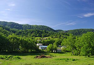
Lee County covers about 437 square miles (1,132 km²). Most of this is land (436 square miles or 1,129 km²), with a small amount of water. Lee County is part of the Appalachian Regional Commission. It is also considered part of "Greater Appalachia."
It's interesting to know that all of Lee County is located west of West Virginia. Also, Lee County is physically closer to eight other state capitals than it is to its own capital, Richmond. These capitals include Raleigh, North Carolina; Columbia, South Carolina; Atlanta, Georgia; Nashville, Tennessee; Charleston, West Virginia; Frankfort, Kentucky; Columbus, Ohio; and Indianapolis, Indiana. The far western part of Lee County is even closer to Montgomery, Alabama!
The county has a unique type of land called "karst." This is an area with Ordovician limestone. The Powell River flows through Lee County on its way to Tennessee.
Districts and Towns
Lee County is divided into seven districts: Jonesville, Rocky Station, Rocky Station Mineral, Rose Hill, White Shoals, Yoakum, and Yoakum Mineral. The two main towns are Pennington Gap and Jonesville.
Neighboring Counties
Lee County shares borders with these counties:
- Wise County, Virginia – to the northeast
- Scott County, Virginia – to the east
- Hancock County, Tennessee – to the south
- Claiborne County, Tennessee – to the south-southwest
- Bell County, Kentucky – to the west
- Harlan County, Kentucky – to the northwest
Protected Areas
Lee County is home to parts of two national protected areas:
- Cumberland Gap National Historical Park
- Jefferson National Forest
It also has a state protected area:
- The Cedars Natural Area Preserve
Major Roads
 US 58
US 58
 US 58 Alt.
 US 421
 SR 70
SR 70 SR 352
 SR 600
Population Information
| Historical population | |||
|---|---|---|---|
| Census | Pop. | %± | |
| 1800 | 3,538 | — | |
| 1810 | 4,694 | 32.7% | |
| 1820 | 4,256 | −9.3% | |
| 1830 | 6,461 | 51.8% | |
| 1840 | 8,441 | 30.6% | |
| 1850 | 10,267 | 21.6% | |
| 1860 | 11,032 | 7.5% | |
| 1870 | 13,268 | 20.3% | |
| 1880 | 15,116 | 13.9% | |
| 1890 | 18,216 | 20.5% | |
| 1900 | 19,856 | 9.0% | |
| 1910 | 23,840 | 20.1% | |
| 1920 | 25,293 | 6.1% | |
| 1930 | 30,419 | 20.3% | |
| 1940 | 39,296 | 29.2% | |
| 1950 | 36,106 | −8.1% | |
| 1960 | 25,824 | −28.5% | |
| 1970 | 20,321 | −21.3% | |
| 1980 | 25,956 | 27.7% | |
| 1990 | 24,496 | −5.6% | |
| 2000 | 23,589 | −3.7% | |
| 2010 | 25,587 | 8.5% | |
| 2020 | 22,173 | −13.3% | |
| 2023 (est.) | 21,745 | −15.0% | |
| U.S. Decennial Census 1900–1990 1990–2000 2010 2020 |
|||
2020 Census Details
| Race / Ethnicity (NH = Non-Hispanic) | Pop 2010 | Pop 2020 | % 2010 | % 2020 |
|---|---|---|---|---|
| White alone (NH) | 23,893 | 20,193 | 93.38% | 91.07% |
| Black or African American alone (NH) | 909 | 868 | 3.55% | 3.91% |
| Native American or Alaska Native alone (NH) | 96 | 69 | 0.38% | 0.31% |
| Asian alone (NH) | 55 | 39 | 0.21% | 0.18% |
| Pacific Islander alone (NH) | 8 | 0 | 0.03% | 0.00% |
| Some Other Race alone (NH) | 22 | 33 | 0.09% | 0.15% |
| Mixed Race/Multi-Racial (NH) | 198 | 495 | 0.77% | 2.23% |
| Hispanic or Latino (any race) | 406 | 476 | 1.59% | 2.15% |
| Total | 25,587 | 22,173 | 100.00% | 100.00% |
In 2020, the county's population was 22,173. Most residents were White (91.07%). Other groups included Black or African American (3.91%), Native American (0.31%), and Asian (0.18%). About 2.23% of people identified as mixed race. People of Hispanic or Latino background made up 2.15% of the population.
Ancestry Groups
The largest ancestry groups in Lee County include:
- English (14%)
- Irish (11%)
- German (9%)
- Scottish-Irish (3%)
Lee County Sheriff's Office
| Lee County Sheriff's Office | |
|---|---|
| Abbreviation | LCSO |
| Agency overview | |
| Employees | 42 |
| Jurisdictional structure | |
| Constituting instrument |
|
| General nature | |
| Operational structure | |
| Headquarters | Jonesville, Virginia |
| Deputies | 39 |
| Civilians | 3 |
| Agency executive |
|
| Website | |
| Official Website: http://www.leecountysheriff.net/ | |
The Lee County Sheriff's Office (LCSO) is in charge of law enforcement in the county. The current Sheriff is Gary B. Parsons. He has been in this role since 1996, making him the longest-serving sheriff in Lee County's history.
Education in Lee County
The Lee County School System manages eleven schools. This includes two high schools and one technical school.
Public High Schools
- Lee High School, Jonesville
- Thomas Walker High School, Ewing
Public Middle Schools
- Elydale Middle School, Ewing
- Jonesville Middle School, Jonesville
- Pennington Middle School, Pennington Gap
Public Elementary Schools
- Dryden Elementary School, Dryden
- Elk Knob Elementary School, Pennington Gap
- Flatwoods Elementary School, Jonesville
- Rose Hill Elementary School, Rose Hill
- St. Charles Elementary School, St. Charles
Former Schools
Pennington Elementary School was torn down in 1989. A bank was built where it used to be. Three other elementary schools, Ewing, Keokee, and Stickleyville, closed in June 2012.
Technical Schools
- Lee County Career & Technical Center, Ben Hur
Communities in Lee County
Towns
Census-Designated Places
These are areas that are like towns but are not officially incorporated as towns:
Other Communities
- Ben Hur
- Blackwater
- Darbyville
- Ewing
- Gibson Station
- Jasper
- Monarch
- Ocoonita
- Olinger
- Seminary
- Stickleyville
- Stone Creek
- Woodway
Notable People from Lee County
Many interesting people have come from Lee County:
- Frank Rowlett, a cryptologist who worked with secret codes
- Carol Wood, a mathematician
- Campbell Slemp, a congressman
- Andrew Taylor Still, who started osteopathic medicine
- William C. Wampler, a U.S. Representative
- Barry Audia, a professional boxer
- Jim Pankovits, a Major League Baseball player
- Elbert S. Martin, a congressman
- John Preston Martin, a U.S. Senator from Kentucky
- Steve Rasnic Tem, an author
- Glen Morgan Williams, a federal judge
- Don Newton, a comic artist
- James Buchanan Richmond, a congressman
- C. Bascom Slemp, a congressman
- Claude Ely, a singer and songwriter
- Walker Cress, a Major League Baseball player
- Cynthia D Kinser, a Chief Justice of the Supreme Court of Virginia
- Pete DeBusk, who founded DeRoyal Industries
In Popular Culture
The 2022 novel Demon Copperhead by Barbara Kingsolver is set in Lee County. This book was inspired by David Copperfield by Charles Dickens. The main character in Demon Copperhead is born into poverty and becomes an orphan, similar to Copperfield.
See also
 In Spanish: Condado de Lee (Virginia) para niños
 | Delilah Pierce |
 | Gordon Parks |
 | Augusta Savage |
 | Charles Ethan Porter |


