Scott County, Virginia facts for kids
Quick facts for kids
Scott County
|
|||
|---|---|---|---|

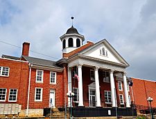
Scott County Courthouse in 2013
|
|||
|
|||

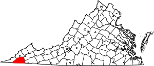
Location within the U.S. state of Virginia
|
|||
 Virginia's location within the U.S. |
|||
| Country | |||
| State | |||
| Founded | November 24, 1814 | ||
| Named for | Winfield Scott | ||
| Seat | Gate City | ||
| Largest town | Gate City | ||
| Area | |||
| • Total | 539 sq mi (1,400 km2) | ||
| • Land | 536 sq mi (1,390 km2) | ||
| • Water | 3.1 sq mi (8 km2) 0.6% | ||
| Population
(2020)
|
|||
| • Total | 21,576 | ||
| • Estimate
(2023)
|
21,433 |
||
| • Density | 40.03/sq mi (15.456/km2) | ||
| Time zone | UTC−5 (Eastern) | ||
| • Summer (DST) | UTC−4 (EDT) | ||
| Congressional district | 9th | ||
Scott County is a county in the far southwestern part of Virginia, a state in the United States. It sits right on the border with Tennessee.
In 2020, about 21,576 people lived here. The main town and county seat is Gate City. Scott County was created on November 24, 1814. It was formed from parts of other counties: Washington, Lee, and Russell. The county is named after General Winfield Scott, who was born in Virginia.
Scott County is part of a larger area known as the "Tri-Cities" region. This area includes Kingsport and Bristol in Tennessee, and Bristol in Virginia. The current County Administrator is Freda Russell Starnes.
History
For thousands of years, Native American groups lived in this area. Early European settlers found signs of an old Native American village. This village was located near where Stony Creek meets the Clinch River. Some Cherokee groups also lived in the area.
In 1769, Thomas McCulloch was the first white settler in what would become Scott County. Daniel Boone commanded several forts here in 1774. These forts were built during a conflict called Dunmore's War. More forts were built in the years that followed.
As more colonial Americans settled, they moved onto Cherokee lands. A group of Cherokee, led by Bob Benge, had fights with the settlers. These conflicts were part of the Cherokee–American wars. Bob Benge was killed in 1794.
By the 1790s, many Scots-Irish people had moved here. They were mostly farmers who owned their own land. They came to the backcountry because land was easier to get. The Wilderness Road helped traders come to the area. Scott County was officially formed in 1814. The first court meeting happened in 1815.
Public schools were not set up in Scott County until 1870. This was after the American Civil War. During this time, wealthy families in Virginia paid for their children's schooling. But they did not pay for other children to go to school.
Geography

Scott County covers about 539 square miles (1,396 square kilometers). Most of this area, 536 square miles (1,388 square kilometers), is land. Only a small part, about 3.1 square miles (8.0 square kilometers), is water.
Scott County is one of many counties in the Appalachian Regional Commission. This group works to help the Appalachian region grow. The county is also part of "Greater Appalachia." This term describes a cultural region in North America.
Adjacent counties
- Wise County - north
- Russell County - northeast
- Washington County - east
- Sullivan County, Tennessee - south
- Hawkins County, Tennessee - south
- Hancock County, Tennessee - southwest
- Lee County - west
National protected area
- Jefferson National Forest (part)
Major highways
 US 23
US 23 US 58
US 58 US 421
 SR 65
SR 65 SR 71
SR 71 SR 72
SR 72
Demographics
| Historical population | |||
|---|---|---|---|
| Census | Pop. | %± | |
| 1820 | 4,263 | — | |
| 1830 | 5,724 | 34.3% | |
| 1840 | 7,303 | 27.6% | |
| 1850 | 9,829 | 34.6% | |
| 1860 | 12,072 | 22.8% | |
| 1870 | 13,036 | 8.0% | |
| 1880 | 17,233 | 32.2% | |
| 1890 | 21,694 | 25.9% | |
| 1900 | 22,694 | 4.6% | |
| 1910 | 23,814 | 4.9% | |
| 1920 | 24,776 | 4.0% | |
| 1930 | 24,181 | −2.4% | |
| 1940 | 26,989 | 11.6% | |
| 1950 | 27,640 | 2.4% | |
| 1960 | 25,813 | −6.6% | |
| 1970 | 24,376 | −5.6% | |
| 1980 | 25,068 | 2.8% | |
| 1990 | 23,204 | −7.4% | |
| 2000 | 23,403 | 0.9% | |
| 2010 | 23,177 | −1.0% | |
| 2020 | 21,576 | −6.9% | |
| 2023 (est.) | 21,433 | −7.5% | |
| U.S. Decennial Census 1790-1960 1900-1990 1990-2000 2010 2020 |
|||
2020 census
The 2020 census counted 21,576 people in Scott County. Most people, about 95%, identified as White. About 1% of the population identified as Hispanic or Latino. Other groups like Black or African American, Native American, and Asian people also live in the county.
| Race / Ethnicity | Pop 2010 | Pop 2020 | % 2010 | % 2020 |
|---|---|---|---|---|
| White alone (NH) | 22,585 | 20,528 | 97.45% | 95.14% |
| Black or African American alone (NH) | 135 | 134 | 0.58% | 0.62% |
| Native American or Alaska Native alone (NH) | 48 | 26 | 0.21% | 0.12% |
| Asian alone (NH) | 35 | 20 | 0.15% | 0.09% |
| Pacific Islander alone (NH) | 0 | 2 | 0.00% | 0.01% |
| Some Other Race alone (NH) | 3 | 28 | 0.01% | 0.13% |
| Mixed Race/Multi-Racial (NH) | 137 | 583 | 0.59% | 2.70% |
| Hispanic or Latino (any race) | 234 | 255 | 1.01% | 1.18% |
| Total | 23,177 | 21,576 | 100.00% | 100.00% |
Note: the US Census treats Hispanic/Latino as an ethnic category. This table excludes Latinos from the racial categories and assigns them to a separate category. Hispanics/Latinos can be of any race.
In 2000, the average age in the county was 41 years old. About 20.6% of the population was under 18. About 17.8% of the population was 65 years or older.
Education
Public secondary schools
- Gate City High School, Gate City
- Rye Cove High School, Rye Cove
- Twin Springs High School, Nickelsville
Public intermediate schools
Public primary schools
- Dungannon Elementary School, Dungannon
- Duffield Primary School, Duffield
- Fort Blackmore Center, Fort Blackmore
- Hilton Elementary School, Hiltons
- Nickelsville Elementary School, Nickelsville
- Shoemaker Elementary School, Gate City
- Weber City Elementary School, Weber City
- Yuma Elementary School, Yuma
Technical schools
- Scott County Career and Technical Center, Gate City
Private schools
- Gate City Christian School (United Pentecostal affiliation), Gate City
Former schools
- Clinchport Elementary School, Clinchport (Destroyed by flood, 1977)
- Cleveland High School, Yuma (Closed, 1956) (Demolished)
- Dungannon High School, Dungannon (Closed, 1968)
- Fairview School, Fairview (Closed, 1990)
- Hilton High School, Hiltons (Closed, 1956) (Demolished)
- Midway School, Midway (Closed, 1968) (Demolished)
- Manville School, Manville (Closed, 1972)
- Nickelsville High School, Nickelsville (Closed, 1968) (Demolished)
- Old Rye Cove School, Rye Cove (Destroyed by tornado, 1929)
- Old Shoemaker Elementary School, Gate City (Destroyed by fire, 1957)
- Prospect Elementary School, Gate City (Closed, 1965) (Demolished)
Communities
Towns
Unincorporated communities
- Antioch
- Copper Creek
- Daniel Boone
- Fairview
- Fort Blackmore
- Fulkerson
- Glenita
- Hill Station
- Hiltons
- Kermit
- Ketrontown
- Mabe
- Maces Spring
- Manville
- Midway
- Nottingham
- Pattonsville
- Rye Cove
- Slabtown
- Slant
- Snowflake
- Speers Ferry
- Stanleytown
- Sunbright
- Wadlow Gap
- Wood
- Yuma
Notable people
- June Carter Cash
- The Carter Family
- Claude M. Hilton
- Jerry Kilgore
- Riley Franklin McConnell (USS McConnell)
- Mac McClung
- Terry Kilgore
See also
 In Spanish: Condado de Scott (Virginia) para niños
 | Aaron Henry |
 | T. R. M. Howard |
 | Jesse Jackson |


