Washington County, Virginia facts for kids
Quick facts for kids
Washington County
|
|||
|---|---|---|---|
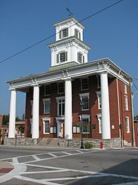
Washington County Courthouse
|
|||
|
|||
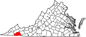
Location within the U.S. state of Virginia
|
|||
 Virginia's location within the U.S. |
|||
| Country | |||
| State | |||
| Founded | 1776 | ||
| Named for | George Washington | ||
| Seat | Abingdon | ||
| Largest town | Abingdon | ||
| Area | |||
| • Total | 566 sq mi (1,470 km2) | ||
| • Land | 561 sq mi (1,450 km2) | ||
| • Water | 5.0 sq mi (13 km2) 0.9% | ||
| Population
(2020)
|
|||
| • Total | 53,935 |
||
| • Density | 95/sq mi (37/km2) | ||
| Time zone | UTC−5 (Eastern) | ||
| • Summer (DST) | UTC−4 (EDT) | ||
| Congressional district | 9th | ||
Washington County is a county located in the state of Virginia. In 2020, about 53,935 people lived there. The main town and county seat is Abingdon. Washington County is part of a larger area known as the "Tri-Cities" region. This region includes Bristol, Tennessee and Virginia, Kingsport, Tennessee, and Johnson City, Tennessee.
Contents
History of Washington County
For thousands of years, different groups of Native Americans lived in this area. When European settlers arrived, the Chiska people had a main village near what is now Saltville. The Cherokee people later took over this region around 1671. They gave the land to the Virginia Colony in 1770 through a special agreement called the Treaty of Lochaber.
The county was officially formed by people from Virginia in 1776. It was created from a larger area called Fincastle County. The county was named after George Washington. He was the leader of the Continental Army during the American Revolutionary War. Washington County was one of the first places in the United States to be named after him.
The Chickamauga Cherokee people sometimes attacked Washington County during the Cherokee–American wars. In July 1776, a chief named Dragging Canoe led an attack on Black's Fort. This fort was later renamed Abingdon in 1778. The area continued to face attacks until after a Chickamauga leader named Bob Benge was defeated in 1794.
Over the years, the county's borders changed. In 1786, the northwestern part of Washington County became Russell County. Later, in 1814, parts of Washington, Lee, and Russell counties joined to form Scott County. In 1832, the northeastern part of Washington County became part of Smyth County. Finally, in 1890, the town of Goodson became the independent city of Bristol. After these changes, Washington County became the size it is today.
Geography of Washington County
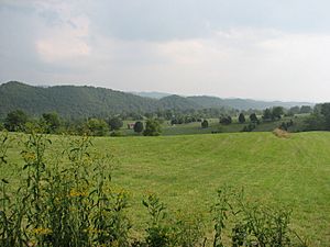
Washington County covers a total area of about 566 square miles (1,466 square kilometers). Most of this area, 561 square miles (1,453 square kilometers), is land. Only about 5 square miles (13 square kilometers) is water. Washington County is located in the Appalachian Mountains region.
County Districts
The county is divided into seven main areas called magisterial districts. These districts are Harrison, Jefferson, Madison, Monroe, Taylor, Tyler, and Wilson.
Neighboring Counties
Washington County shares its borders with several other counties and one independent city:
- Smyth County - to the northeast
- Grayson County - to the east-southeast
- Johnson County, Tennessee - to the south
- Sullivan County, Tennessee - to the southwest
- Bristol (City) - to the southwest
- Scott County - to the west
- Russell County - to the northwest
Protected Natural Areas
Parts of two national protected areas are located in Washington County:
- Jefferson National Forest
- Mount Rogers National Recreation Area
Main Roads and Highways
Several important roads and highways pass through Washington County. These include:
 I-81
I-81 US 11
US 11 US 19
US 19 US 58
US 58
 US 58 Alt.
 US 421
 SR 75
SR 75 SR 80
SR 80 SR 91
SR 91 SR 617
 SR 625
Population and People
| Historical population | |||
|---|---|---|---|
| Census | Pop. | %± | |
| 1790 | 5,625 | — | |
| 1800 | 9,536 | 69.5% | |
| 1810 | 12,156 | 27.5% | |
| 1820 | 12,444 | 2.4% | |
| 1830 | 15,614 | 25.5% | |
| 1840 | 13,001 | −16.7% | |
| 1850 | 14,612 | 12.4% | |
| 1860 | 16,892 | 15.6% | |
| 1870 | 16,816 | −0.4% | |
| 1880 | 25,203 | 49.9% | |
| 1890 | 29,020 | 15.1% | |
| 1900 | 28,995 | −0.1% | |
| 1910 | 32,830 | 13.2% | |
| 1920 | 32,376 | −1.4% | |
| 1930 | 33,850 | 4.6% | |
| 1940 | 38,197 | 12.8% | |
| 1950 | 37,536 | −1.7% | |
| 1960 | 38,076 | 1.4% | |
| 1970 | 40,835 | 7.2% | |
| 1980 | 46,487 | 13.8% | |
| 1990 | 45,887 | −1.3% | |
| 2000 | 51,103 | 11.4% | |
| 2010 | 54,876 | 7.4% | |
| 2020 | 53,935 | −1.7% | |
| U.S. Decennial Census 1790-1960 1900-1990 2010 2020 |
|||
2020 Census Information
The 2020 United States Census collected information about the people living in Washington County. This table shows the different groups of people and how their numbers changed from 2010 to 2020.
| Race / Ethnicity | Pop 2010 | Pop 2020 | % 2010 | % 2020 |
|---|---|---|---|---|
| White alone | 52,798 | 50,338 | 96.21% | 93.33% |
| Black or African American alone | 686 | 651 | 1.25% | 1.21% |
| Native American or Alaska Native alone | 90 | 91 | 0.16% | 0.17% |
| Asian alone | 202 | 334 | 0.37% | 0.62% |
| Pacific Islander alone | 6 | 0 | 0.01% | 0.00% |
| Some Other Race alone | 21 | 134 | 0.04% | 0.25% |
| Mixed Race/Multi-Racial | 349 | 1,496 | 0.64% | 2.77% |
| Hispanic or Latino (any race) | 724 | 891 | 1.32% | 1.65% |
| Total | 54,876 | 53,935 | 100.00% | 100.00% |
Note: The US Census counts Hispanic/Latino people as an ethnic group. This means they can be of any race.
Education in Washington County
Colleges and Universities
- Emory and Henry College, located in Emory
- Virginia Highlands Community College, located in Abingdon
- Virginia Intermont College, which closed in 2014. While its main campus was in Bristol, its Equestrian Center was in Washington County. This center is now part of Emory & Henry College.
Public High Schools
- Abingdon High School, in Abingdon
- Holston High School, in Damascus
- John S. Battle High School, near Bristol
- Patrick Henry High School, in Glade Spring
Communities in Washington County
Towns
- Abingdon
- Damascus
- Glade Spring
- Saltville (partially in Smyth County)
Census-Designated Places
These are areas that are like towns but are not officially incorporated as towns.
Other Communities
Many other smaller communities are located in Washington County. Some of these include:
- Alvarado
- Azen
- Bethel
- Blackwell
- Clinchburg
- Friendship
- Goose Pimple Junction
- Greendale
- Green Spring
- Hayter
- Holston
- Konnarock
- Lindell
- Lodi
- Mendota
- Osecola
- Plasterco
- Taylors Valley
- Wyndale
Some parts of Washington County use Bristol addresses, even though they are not in the city of Bristol itself.
Notable People from Washington County
Many interesting people have come from Washington County, Virginia. Here are a few of them:
- Frederick C. Boucher - A member of the U.S. Congress.
- Red Byron - A famous race car driver.
- David Campbell - A former Governor of Virginia.
- John Buchanan Floyd - Also a Governor of Virginia and a U.S. Secretary of War.
- Robert William Hughes - A lawyer and newspaper publisher who became a U.S. District Court judge.
- John Warfield Johnston - A lawyer, judge, and U.S. Senator.
- Barbara Kingsolver - A well-known writer and novelist.
- Joseph Meek - An American frontiersman.
- William Frank Newton - A talented jazz musician.
- John E. Reinhardt - An Ambassador to Nigeria and Director of the U.S. Information Agency.
- Wyndham Robertson - Another former Governor of Virginia.
- Connally Findlay Trigg - A member of the U.S. Congress.
- Hiram Emory Widener, Jr. - A U.S. District Court and U.S. Court of Appeals judge.
See also
 In Spanish: Condado de Washington (Virginia) para niños
 | Victor J. Glover |
 | Yvonne Cagle |
 | Jeanette Epps |
 | Bernard A. Harris Jr. |


