
Johnson County, Tennessee facts for kids
Quick facts for kids
Johnson County
|
|||
|---|---|---|---|

Johnson County Courthouse in Mountain City
|
|||
|
|||

Location within the U.S. state of Tennessee
|
|||
 Tennessee's location within the U.S. |
|||
| Country | |||
| State | |||
| Founded | 1836 | ||
| Named for | Thomas Johnson, early settler | ||
| Seat | Mountain City | ||
| Largest town | Mountain City | ||
| Area | |||
| • Total | 303 sq mi (780 km2) | ||
| • Land | 298 sq mi (770 km2) | ||
| • Water | 4.2 sq mi (11 km2) 1.4%% | ||
| Population
(2020)
|
|||
| • Total | 17,948 |
||
| • Density | 61/sq mi (24/km2) | ||
| Time zone | UTC−5 (Eastern) | ||
| • Summer (DST) | UTC−4 (EDT) | ||
| Congressional district | 1st | ||


Johnson County is a county located in the U.S. state of Tennessee. In 2020, about 17,948 people lived here. Its main town, or county seat, is Mountain City. This county is in the very northeast part of Tennessee. It shares its borders with Virginia and North Carolina.
Contents
History of Johnson County
Johnson County was created in 1836. It was formed from parts of Carter County. Before this, people in the area that is now Johnson County felt it was too hard to travel to Elizabethton. Elizabethton was the main town of Carter County at the time.
They asked to move the main town to a more central spot. When their request was turned down, they asked the state government to create a new county. The new county was named after Thomas Johnson, who was an early settler in the area. The county's main town was first called "Taylorsville." This was to honor Colonel James P. Taylor. Later, in the 1880s, its name was changed to "Mountain City."
During the American Civil War, most people in Johnson County supported the Union. In 1861, the county voted against leaving the United States. The vote was 788 to 111. The county also sent many people to a meeting in Greeneville. This meeting was for people in East Tennessee who supported the Union.
Because Johnson County was far away from bigger cities, railroads did not arrive until the early 1900s. When the railroads finally came, they helped the timber (wood) and manganese mining industries grow.
Geography of Johnson County


Johnson County covers about 303 square miles. Most of this area, about 298 square miles, is land. The rest, about 4.2 square miles, is water.
The county is entirely within the Blue Ridge Mountains. This means it has many hills and rugged areas. The border with Sullivan County to the northwest is along the top of Holston Mountain. The Iron Mountains form the border with Carter County to the southwest. Snake Mountain is the highest point in the county. It is about 5,574 feet tall.
High Places in Johnson County
Johnson County has one of the highest average elevations in Tennessee. It is home to the two highest communities in the state. These are Trade, which is about 3,133 feet high, and Shady Valley, which is about 2,785 feet high. Mountain City is the highest incorporated city in Tennessee. It sits at about 2,418 feet above sea level. The highest point in Johnson County is a lower peak of Snake Mountain. It is near the North Carolina border and is about 5,518 feet high. The lowest point in the county is Watauga Lake, which is about 1,959 feet high.
Lakes in Johnson County
Counties Next to Johnson County
- Washington County, Virginia (north)
- Grayson County, Virginia (northeast)
- Ashe County, North Carolina (east)
- Watauga County, North Carolina (southeast)
- Avery County, North Carolina (south)
- Carter County (southwest)
- Sullivan County (west)
Protected Areas
- Appalachian Trail (part of it runs through the county)
- Cherokee National Forest (part of it is in the county)
People of Johnson County
| Historical population | |||
|---|---|---|---|
| Census | Pop. | %± | |
| 1840 | 2,658 | — | |
| 1850 | 3,705 | 39.4% | |
| 1860 | 5,018 | 35.4% | |
| 1870 | 5,852 | 16.6% | |
| 1880 | 7,766 | 32.7% | |
| 1890 | 8,858 | 14.1% | |
| 1900 | 10,589 | 19.5% | |
| 1910 | 13,191 | 24.6% | |
| 1920 | 12,230 | −7.3% | |
| 1930 | 12,209 | −0.2% | |
| 1940 | 12,998 | 6.5% | |
| 1950 | 12,278 | −5.5% | |
| 1960 | 10,765 | −12.3% | |
| 1970 | 11,569 | 7.5% | |
| 1980 | 13,745 | 18.8% | |
| 1990 | 13,766 | 0.2% | |
| 2000 | 17,499 | 27.1% | |
| 2010 | 18,244 | 4.3% | |
| 2020 | 17,948 | −1.6% | |
| U.S. Decennial Census 1790-1960 1900-1990 1990-2000 2010-2014 |
|||
2020 Census Information
| Race | Number | Percentage |
|---|---|---|
| White (not Hispanic) | 16,126 | 89.85% |
| Black or African American (not Hispanic) | 724 | 4.03% |
| Native American | 28 | 0.16% |
| Asian | 27 | 0.15% |
| Pacific Islander | 9 | 0.05% |
| Other/Mixed | 518 | 2.89% |
| Hispanic or Latino | 516 | 2.87% |
In 2020, there were 17,948 people living in Johnson County. There were 6,794 households and 4,635 families.
Communities in Johnson County


Town
- Mountain City (This is the county's main town)
Unincorporated Communities
Images for kids
-
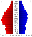
Age pyramid for Johnson County.

See also
 In Spanish: Condado de Johnson (Tennessee) para niños
