
Ashe County, North Carolina facts for kids
Quick facts for kids
Ashe County
|
|||
|---|---|---|---|

Ashe County Courthouse in Jefferson
|
|||
|
|||

Location within the U.S. state of North Carolina
|
|||
 North Carolina's location within the U.S. |
|||
| Country | |||
| State | |||
| Founded | 1799 | ||
| Named for | Samuel Ashe | ||
| Seat | Jefferson | ||
| Largest community | Jefferson | ||
| Area | |||
| • Total | 429.37 sq mi (1,112.1 km2) | ||
| • Land | 426.26 sq mi (1,104.0 km2) | ||
| • Water | 3.11 sq mi (8.1 km2) 0.72% | ||
| Population
(2020)
|
|||
| • Total | 26,577 | ||
| • Estimate
(2023)
|
27,063 | ||
| • Density | 62.35/sq mi (24.07/km2) | ||
| Time zone | UTC−5 (Eastern) | ||
| • Summer (DST) | UTC−4 (EDT) | ||
| Congressional district | 5th | ||


Ashe County (pronounced ASH) is a special area called a county in the state of North Carolina. It's like a big neighborhood with its own local government. In 2020, about 26,577 people lived here. The main town, where the county government is, is called Jefferson.
Contents
Exploring Ashe County's Past

Who Lived Here First?
Long ago, before Europeans arrived, Native American tribes lived in Ashe County. These included the Cherokee, Creek, and Shawnee tribes. We know this because people have found old pottery pieces, arrowheads, and other tools they used. Many of these items were found in an area called Old Fields.
Early European Settlers
The first Europeans to explore Ashe County were a group led by Bishop August Gottlieb Spangenberg in the 1700s. He was the leader of the Moravian Church in America. One person from his group, Herman Loesch, later came back to live in Ashe County permanently. Other early settlers included David Helton, William Walling, William McLain, and the famous pioneer Daniel Boone. Most of these families settled here around 1771.
The Revolutionary War and New Beginnings
During the Revolutionary War, a small fight called the Battle of Big Glades happened in Ashe County in July 1780. American soldiers, led by Captain Robert Love, fought against British Loyalists. The Americans won this battle.
In the 1780s, Ashe County was part of a self-declared state called "State of Franklin". This area later became the state of Tennessee. North Carolina officially created Ashe County in late 1799. It was named after Samuel Ashe, who was a hero of the Revolution and a governor of North Carolina. Many families living in Ashe County today have surnames that were also present in the 1800 census!
How Ashe County's Borders Changed
Over many years, from 1807 to 1913, the size of Ashe County changed several times.
- In 1849, part of Ashe County was used to help form Watauga County.
- Ten years later, in 1859, the eastern part of Ashe County became Alleghany County.
Geography and Nature of Ashe County
Where is Ashe County Located?
Ashe County is in the very northwestern part of North Carolina. It shares borders with two other states: Virginia to the north and Tennessee to the west. The entire county is located within the beautiful Appalachian Mountains.
Most of Ashe County sits on a high, rolling plateau, about 2,500 to 3,000 feet (760 to 910 meters) above sea level. On the southeastern side, the land drops sharply. Many mountains and hills are found on this plateau. Five mountains in the county are over 5,000 feet (1,500 meters) tall! A well-known spot is Mount Jefferson, which is a State Natural Area. It rises to 4,665 feet (1,422 meters) and stands tall over the towns of Jefferson and West Jefferson.
The Ancient New River
The main river in Ashe County is the New River. It's one of the oldest rivers in the world! What's special about it is that it flows mostly north, which is unusual for major rivers in the southeastern United States. Many smaller creeks and streams flow into the New River in Ashe County.
In 1998, the New River was named an "American Heritage River" by President Bill Clinton. It's famous for its beautiful views, clear water, and is a great place for fly fishing, kayaking, and canoeing.
A Place of Beauty and Christmas Trees
Because of its mountains, Ashe County was once called one of the "Lost Provinces" of North Carolina. This was because it was hard to reach from the rest of the state.
Today, Ashe County is known for its stunning mountain scenery. Tourism is a very important part of the county's economy. The Blue Ridge Parkway, a famous scenic road, runs along the county's southeastern border.
Historically, Ashe County was mostly farmland with many cattle and poultry farms. However, in recent years, many farmers have started growing Christmas trees instead of raising cattle. Ashe County grows more Christmas trees than any other county in the Eastern United States! Amazingly, an Ashe County Christmas tree has been chosen as the official White House Christmas Tree six times!
Ashe County's Climate
Ashe County has a different climate compared to most of the southeastern United States.
- Summers: Summers are usually mild, averaging around 80 °F (27 °C). Temperatures rarely go above 90 °F (32 °C). Summer nights are cool, often dropping to near 60 °F (16 °C).
- Winters: Winters bring snow, with Jefferson and West Jefferson averaging about 30 inches (76 cm) each year. More snow falls on the higher mountain peaks. Snow can be seen as early as October and as late as May.
- Wind: It can be very windy, especially in winter. Winds can gust up to 60 to 85 MPH (97 to 137 KPH) at the Jefferson Airport.
- Cold: Combined with the wind, winters can be very cold. Temperatures can drop below 0 °F (−18 °C) several times a year. The average winter high is around 45 °F (7 °C), and the average low is near 20 °F (−7 °C). These conditions make Ashe County's winters feel similar to those in the Northeastern United States.
Protected Natural Areas
Ashe County is home to several protected natural areas, which help keep its beautiful environment safe.
- Blue Ridge Parkway (part)
- Cherokee National Forest (part)
- Mountain Bogs National Wildlife Refuge
- Mount Jefferson State Natural Area
- New River State Park (part)
- Phoenix Lake, Ashe County Park
- Pond Mountain Game Land
- Three Top Mountain Game Land
- West Jefferson Municipal Park
Rivers and Streams
Many important water bodies flow through Ashe County:
- Big Horse Creek
- Brush Creek
- Cranberry Creek
- Grassy Creek
- Helton Creek
- Hoskin Fork
- Jerd Branch
- Little Horse Creek
- Little Phoenix Creek
- Long Hope Creek
- Mill Creek
- Minner Creek
- New River
- North Fork New River
- Obids Creek
- Roundabout Creek
- South Fork New River
Neighboring Counties
Ashe County is surrounded by other counties:
- Grayson County, Virginia – north
- Alleghany County – east
- Wilkes County – southeast
- Watauga County – southwest
- Johnson County, Tennessee – west
Main Roads and Transportation
These are the major roads that help people travel in and out of Ashe County:
 US 221


US 221 Bus. NC 16
NC 16 NC 88
NC 88 NC 163
 NC 194
The county also has its own airport:
- Ashe County Airport
People of Ashe County
| Historical population | |||
|---|---|---|---|
| Census | Pop. | %± | |
| 1800 | 2,783 | — | |
| 1810 | 3,694 | 32.7% | |
| 1820 | 4,335 | 17.4% | |
| 1830 | 6,987 | 61.2% | |
| 1840 | 7,467 | 6.9% | |
| 1850 | 8,777 | 17.5% | |
| 1860 | 7,956 | −9.4% | |
| 1870 | 9,573 | 20.3% | |
| 1880 | 14,437 | 50.8% | |
| 1890 | 15,628 | 8.2% | |
| 1900 | 19,581 | 25.3% | |
| 1910 | 19,074 | −2.6% | |
| 1920 | 21,001 | 10.1% | |
| 1930 | 21,019 | 0.1% | |
| 1940 | 22,664 | 7.8% | |
| 1950 | 21,878 | −3.5% | |
| 1960 | 19,768 | −9.6% | |
| 1970 | 19,571 | −1.0% | |
| 1980 | 22,325 | 14.1% | |
| 1990 | 22,209 | −0.5% | |
| 2000 | 24,384 | 9.8% | |
| 2010 | 27,281 | 11.9% | |
| 2020 | 26,577 | −2.6% | |
| 2023 (est.) | 27,063 | −0.8% | |
| U.S. Decennial Census 1790–1960 1900–1990 1990–2000 2010 2020 |
|||
Population in 2020
In 2020, there were 26,577 people living in Ashe County. There were 11,938 households and 7,894 families. Ashe County has a very high percentage of white residents compared to other counties in North Carolina.
| Group | Number | Percentage |
|---|---|---|
| White (not Hispanic) | 24,028 | 90.41% |
| Black or African American (not Hispanic) | 125 | 0.47% |
| Native American | 48 | 0.18% |
| Asian | 102 | 0.38% |
| Pacific Islander | 12 | 0.05% |
| Other/Mixed | 743 | 2.8% |
| Hispanic or Latino | 1,519 | 5.72% |
Local News
The main newspaper for Ashe County is The Ashe Post and Times. It comes out every Wednesday and shares the latest news and events. You can also find breaking news on their website, ashepostandtimes.com.
Towns and Communities

Main Towns
- Jefferson (This is the county seat and the biggest town.)
- Lansing
- West Jefferson
Smaller Communities (Townships)
- Chestnut Hill
- Clifton
- Creston
- Elk
- Grassy Creek
- Helton
- Horse Creek
- Hurricane
- Jefferson
- Laurel
- North Fork
- Obids
- Old Fields
- Peak Creek
- Pine Swamp
- Piney Creek
- Pond Mountain
- Walnut Hill
- West Jefferson
Unincorporated Communities
These are smaller places that are not officially towns or cities:
- Apple Grove
- Ashland
- Baldwin
- Beaver Creek
- Bina
- Brandon
- Brownwood
- Chestnut Hill
- Clifton
- Comet
- Creston
- Crumpler
- Fig
- Fleetwood
- Glendale Springs
- Grassy Creek
- Grayson
- Helton
- Husk
- Idlewild
- Nathans Creek
- Obids
- Orion
- Parker
- Scottville
- Shatley Springs
- Smethport
- Sturgills
- Sutherland
- Todd
- Toliver
- Tuckerdale
- Wagoner
- Warrensville
- Weavers Ford
- Woodford
- Yates
Town Populations (2020 Census)
Here are the populations of the main towns in Ashe County:
| Rank | Name | Type | Population (2020 census) |
|---|---|---|---|
| 1 | † Jefferson | Town | 1,622 |
| 2 | West Jefferson | Town | 1,279 |
| 3 | Lansing | Town | 126 |
† = county seat
Famous People and Visitors
People From Ashe County
- Daniel Boone: A famous American pioneer who lived in Ashe County for some years.
- G. B. Grayson: A talented fiddler (violin player).
- Monte Weaver: A professional baseball player who was a pitcher in Major League Baseball from 1931 to 1939.
Notable Visitors to Ashe County
- In 1998, President Bill Clinton and Vice President Al Gore visited the New River. They held a ceremony to name it an American Heritage River.
- Helen Keller: She visited Marvin Osborne, an Ashe County native, in 1944. He had been injured while serving in France during World War II.
- Loretta Lynn: The famous country singer performed at the Central Food Market in West Jefferson in the late 1960s.
Images for kids
-
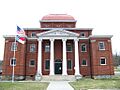
Ashe County Courthouse in Jefferson
-
Seal of Ashe County, North Carolina
-
Ashe County Flag
See also
 In Spanish: Condado de Ashe para niños
