
Mount Jefferson State Natural Area facts for kids
Quick facts for kids Mount Jefferson State Natural Area |
|
|---|---|
|
IUCN Category III (Natural Monument)
|
|
 |
|

Mount Jefferson State Natural Area
Location in North Carolina
|
|
| Location | Ashe, North Carolina, United States |
| Area | 1,188 acres (4.81 km2) |
| Elevation | 4,660 ft (1,420 m) |
| Established | 1956 |
| Named for | Mount Jefferson |
| Governing body | North Carolina Division of Parks and Recreation |
| Website | |
| Designated: | 1974 |
Mount Jefferson State Natural Area is a special place in Ashe County, North Carolina, in the United States. It's a large park, covering about 1,188 acres (that's like 900 football fields!). This park protects the tall peak of Mount Jefferson. The mountain was named after Thomas Jefferson and his father, Peter, who were important people in early American history. They even surveyed land nearby in 1749. In 1974, Mount Jefferson State Natural Area was recognized as a National Natural Landmark. This means it has unique natural features that are important to protect. The park is managed by the North Carolina Division of Parks and Recreation.
Contents
History of Mount Jefferson Park
For a long time, Mount Jefferson didn't have an official name. People often called it "Panther Mountain." This was likely because of a local story about a panther that lived there. In 1939, a group called the Works Progress Administration (WPA) built a road. This road made it much easier for people to visit the mountain.
Local people really wanted the mountain to become a state park. To become a state park, an area needed to be at least 400 acres. Citizens worked hard, donating land and money. By 1956, they had donated 300 acres and raised enough money to buy another 164 acres. Because of their efforts, Mount Jefferson officially got its name and became a state park in October 1956.
Visiting Mount Jefferson State Natural Area
Mount Jefferson State Natural Area has one main road that goes all the way to the top of the mountain. As you drive up, you'll find three amazing spots to stop and enjoy the view. These are the Sunset Overlook, the Sunrise Overlook, and the Jefferson Overlook.
At the very top of the mountain, there's a picnic shelter where you can relax and eat. From here, you can start exploring the park's hiking trails.
- The Summit Trail is a short 0.3-mile path.
- It leads to the 1.1-mile Rhodedendron Trail loop.
- At the end of this loop, a short path takes you to Luther Rock, which offers more beautiful views.
- From there, you can also find the entrances to the 0.75-mile Lost Province Trail loop.
The mountain itself rises more than 1,600 feet above the land around it. This means you get a fantastic bird's-eye view of the towns of Jefferson and West Jefferson.
The park is open every day until sunset, except on Christmas Day. However, park hours can change due to bad weather. There's also a 2-mile, one-way Mountain Ridge Trail. You can access this trail at the first park gate, across from the park office, even when the weather is bad. Just be careful if you hike during bad weather.
Nearby State Parks
If you enjoy visiting state parks, here are some others close to Mount Jefferson State Natural Area (within 30 miles):
- Elk Knob State Park
- Grandfather Mountain State Park
- Grayson Highlands State Park, in Virginia
- New River State Park
- Stone Mountain State Park
Images for kids
-
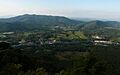
View from Mount Jefferson

