Grayson County, Virginia facts for kids
Quick facts for kids
Grayson County
|
||
|---|---|---|

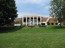
Present-day Grayson County Courthouse
|
||
|
||

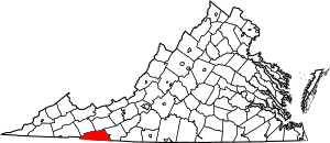
Location within the U.S. state of Virginia
|
||
 Virginia's location within the U.S. |
||
| Country | ||
| State | ||
| Founded | 1793 | |
| Named for | William Grayson | |
| Seat | Independence | |
| Largest town | Independence | |
| Area | ||
| • Total | 446 sq mi (1,160 km2) | |
| • Land | 442 sq mi (1,140 km2) | |
| • Water | 3.8 sq mi (10 km2) 0.8% | |
| Population
(2020)
|
||
| • Total | 15,333 | |
| • Density | 34.38/sq mi (13.274/km2) | |
| Time zone | UTC−5 (Eastern) | |
| • Summer (DST) | UTC−4 (EDT) | |
| Congressional district | 9th | |
Grayson County is a county located in the southwestern part of Virginia. In 2020, about 15,333 people lived there. The main town, or county seat, is Independence.
Grayson County is also home to Mount Rogers. This is the highest mountain in Virginia, standing tall at 5,729 feet (1,746 m).
Contents
Discovering Grayson County's Past
How Grayson County Began
Grayson County was created in 1793. It was formed from a part of Wythe County. The county was named after William Grayson. He was an important person who served in the Continental Congress and was one of Virginia's first U.S. Senators.
The first courthouse was built in a place called Greensville in 1794. This town was later known as Oldtown. The courthouse was rebuilt starting in 1832. In 1842, the state government decided to divide Grayson County. The northeastern part became Carroll County.
Grayson County During the Civil War
Not much fighting happened directly in Grayson County during the American Civil War. However, many local men joined the war effort. A group called the "Grayson Dare Devils" was formed from the Elk Creek Valley. They were part of the famous Stonewall Brigade. This group suffered many losses early in the war.
Another group, the Grayson Cavalry, served until the war ended. The "Wilson Rifles" were also formed in the Mouth of Wilson Community. These groups show how people from Grayson County contributed to the war.
Changes in County Life and Towns
The county seat moved to Independence, Virginia before the Civil War. This happened because the old county seat was no longer central after Carroll County was created. The old courthouse from 1834 is still around today. It is now near the city of Galax, Virginia.
For a long time, the closest railroad was about nine miles away from Grayson County. This was a stop called "Rural Retreat." Later, factories for textiles and furniture came to Galax. This town was planned in 1903 and named after a plant found in the mountains.
The New River was also dammed at Fries. This helped power a cotton mill. Some towns, like Whitetop City and Fairwood, almost disappeared during the Great Depression.
Exploring Grayson County's Landscape
Where is Grayson County Located?
Grayson County covers about 446 square miles (1,160 km2) in total. Most of this area, 442 square miles (1,140 km2), is land. Only a small part, 3.8 square miles (9.8 km2) (0.8%), is water.
This county is part of the Appalachian Regional Commission. It is also known for having the southernmost point in Virginia. Interestingly, it is the only county in Virginia with an Oceanic climate. This means it has mild winters and cool summers.
Neighboring Areas of Grayson County
Grayson County shares its borders with several other counties and one independent city:
- Johnson County, Tennessee (to the southwest)
- Washington County, Virginia (to the west)
- Smyth County (to the northwest)
- Wythe County (to the northeast)
- Ashe County, North Carolina (to the south)
- Alleghany County, North Carolina (to the south)
- Surry County, North Carolina (to the southeast)
- Independent City of Galax (to the east)
- Carroll County (to the east)
Protected Natural Areas
Parts of these important natural areas are found in Grayson County:
- Blue Ridge Parkway
- Jefferson National Forest
- Mount Rogers National Recreation Area
Main Roads in Grayson County
These are some of the major highways that run through Grayson County:
 US 21
US 21 US 58
US 58 US 221
 SR 16
SR 16 SR 89
SR 89 SR 93
SR 93 SR 94
SR 94 SR 274
People and Population in Grayson County
| Historical population | |||
|---|---|---|---|
| Census | Pop. | %± | |
| 1800 | 3,912 | — | |
| 1810 | 4,941 | 26.3% | |
| 1820 | 5,598 | 13.3% | |
| 1830 | 7,675 | 37.1% | |
| 1840 | 9,087 | 18.4% | |
| 1850 | 6,677 | −26.5% | |
| 1860 | 8,252 | 23.6% | |
| 1870 | 9,587 | 16.2% | |
| 1880 | 13,068 | 36.3% | |
| 1890 | 14,394 | 10.1% | |
| 1900 | 16,853 | 17.1% | |
| 1910 | 19,856 | 17.8% | |
| 1920 | 19,816 | −0.2% | |
| 1930 | 20,017 | 1.0% | |
| 1940 | 21,916 | 9.5% | |
| 1950 | 21,379 | −2.5% | |
| 1960 | 17,930 | −16.1% | |
| 1970 | 15,439 | −13.9% | |
| 1980 | 16,579 | 7.4% | |
| 1990 | 16,278 | −1.8% | |
| 2000 | 17,917 | 10.1% | |
| 2010 | 15,533 | −13.3% | |
| 2020 | 15,333 | −1.3% | |
| U.S. Decennial Census 1790-1960 1900-1990 1990-2000 2010 2020 |
|||
In 2020, the population of Grayson County was 15,333 people. Most residents were White. There were also people of Black or African American, Native American, Asian, and other backgrounds. Some residents identified as being of mixed race. About 3.89% of the population was Hispanic or Latino.
Grayson County's Economy
Grayson County has faced challenges in its economy. It is not near a major interstate highway and is surrounded by mountains. This makes it harder for businesses to move there. The county struggled to create and keep jobs, especially after 2009.
However, there have been improvements. A new prison, the River North Correctional Center, opened and created hundreds of jobs. The county also worked to keep Core Fitness' Nautilus facility. This is the largest employer in the area.
In 2012, a fire badly damaged Independence Lumber. But the county helped the company rebuild and reopen in 2014. This brought back 125 jobs. By 2014, the county's efforts led to 300 more jobs and a lower unemployment rate. By 2019, the unemployment rate was very low, at just 2.6%.
Learning in Grayson County
Public High School
- Grayson County High School, located in Independence
Private High School
- Oak Hill Academy, located in Mouth of Wilson
Music and Culture in Grayson County
Grayson County is in the Appalachian region of the United States. It is well-known for its traditional, or "old-time" music. The area around Mount Airy, North Carolina, and Galax, Virginia, is a place where this music is still very strong. Even young people enjoy playing it.
The Old Fiddler's Convention is a very famous traditional music contest. It has been held every year in Galax since 1935. Grayson County also hosts other music events. These include the Grayson County Fiddlers Convention and the Fries Fiddlers Convention. There is also the Wayne C. Henderson Guitar Festival.
Many well-known old-time bands come from this area. Some of them are The Whitetop Mountain Band, The New Ballards Branch Bogtrotters, The Wolfe Brothers String Band, and the Konnarock Critters.
Towns and Communities
Towns
Census-Designated Places
These are areas that are like towns but are not officially incorporated:
- Baywood
- Hilltown (partly in Carroll County)
- Stevens Creek
Other Communities
- Carsonville
- Comers Rock
- Elk Creek
- Fairview
- Flat Ridge
- Grant
- Mouth of Wilson
- Rugby
- Volney
Notable People from Grayson County
- John Calhoun Dickenson (1815-1890), a farmer and politician
- Henry Whitter (1892–1941), an early country music artist
- Wade Ward (1892–1971), a banjo player and fiddler known for old-time country music
- Estil C. Ball (1913–1978), a singer-songwriter and musician
- Wayne Henderson, a famous guitar maker and player
- Kenneth Y. Tomlinson, a former editor of Reader's Digest
See also
 In Spanish: Condado de Grayson (Virginia) para niños
 | Bayard Rustin |
 | Jeannette Carter |
 | Jeremiah A. Brown |


