Carroll County, Virginia facts for kids
Quick facts for kids
Carroll County
|
||
|---|---|---|

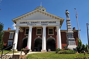
Carroll County Courthouse and Confederate Monument
|
||
|
||

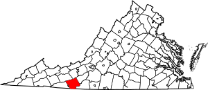
Location within the U.S. state of Virginia
|
||
 Virginia's location within the U.S. |
||
| Country | ||
| State | ||
| Founded | 1842 | |
| Named for | Charles Carroll | |
| Seat | Hillsville | |
| Largest town | Hillsville | |
| Area | ||
| • Total | 478 sq mi (1,240 km2) | |
| • Land | 475 sq mi (1,230 km2) | |
| • Water | 3 sq mi (8 km2) 0.6% | |
| Population
(2020)
|
||
| • Total | 29,155 | |
| • Density | 60.99/sq mi (23.550/km2) | |
| Time zone | UTC−5 (Eastern) | |
| • Summer (DST) | UTC−4 (EDT) | |
| Congressional district | 9th | |
Carroll County is a county in the southwestern part of Virginia. About one-fifth of the county is in the Piedmont region. The rest of the county is part of the Appalachian Mountains. The main town and county seat is Hillsville.
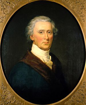
Carroll County was created in 1842. It was formed from a part of Grayson County. The county was named after Charles Carroll. He was an important person who signed the Declaration of Independence.
The total area of the county is about 478 square miles (1,238 square kilometers). In 2020, the population was 29,155 people.
Contents
History of Carroll County
The first European settlers came to this area in the mid-1700s. Many of them were Scotch-Irish pioneers. They were used to living in high mountain areas.
Early settlement was slow because the soil was not good for farming. Because of this, one of the first ways people made money was by lead mining.
As more people moved to the area, Carroll County was formed in 1842. It was created from a part of Grayson County. The county was officially named for Charles Carroll from Maryland. He was a signer of the Declaration of Independence.
Some stories say that John Carroll, a Virginia lawmaker, wanted the county named after himself. But a political rival made sure it was officially named for Charles Carroll instead.
Later, parts of Patrick County were added to Carroll County. The first part was added in 1845. Another part, which is now the Fancy Gap District, was added in 1854.
What is the Geography of Carroll County Like?
Carroll County is unique in Virginia. About one-fifth of its southeastern part has Piedmont land. This means it has rolling hills. The other four-fifths of the county are mountainous. These mountains are part of the Appalachian Mountains. The Blue Ridge escarpment often marks the county lines.
The U.S. Census Bureau says the county covers 478 square miles. Of this, 475 square miles are land. Only 3 square miles (0.6%) are water.
Neighboring Counties and Cities
Carroll County shares borders with several other counties and one city:
- Galax, Virginia - west
- Grayson County, Virginia - west
- Wythe County, Virginia - northwest
- Pulaski County, Virginia - north
- Floyd County, Virginia - northeast
- Patrick County, Virginia - southeast
- Surry County, North Carolina - south
Protected Natural Areas
Carroll County has parts of several protected areas:
- Blue Ridge Parkway (a scenic road)
- Jefferson National Forest (a large forest)
- Mount Rogers National Recreation Area (an area for outdoor fun)
- Devil's Den Nature Preserve (a special nature area)
Major Roads and Highways
These are the main roads that go through Carroll County:
 I-74 (planned for the future)
 I-77
I-77 US 52
US 52 US 58
US 58 US 221
 SR 94
SR 94 SR 100
 SR 148
Population and People in Carroll County
| Historical population | |||
|---|---|---|---|
| Census | Pop. | %± | |
| 1850 | 5,909 | — | |
| 1860 | 8,012 | 35.6% | |
| 1870 | 9,147 | 14.2% | |
| 1880 | 13,323 | 45.7% | |
| 1890 | 15,497 | 16.3% | |
| 1900 | 19,303 | 24.6% | |
| 1910 | 21,116 | 9.4% | |
| 1920 | 21,283 | 0.8% | |
| 1930 | 22,141 | 4.0% | |
| 1940 | 25,904 | 17.0% | |
| 1950 | 26,695 | 3.1% | |
| 1960 | 23,178 | −13.2% | |
| 1970 | 23,092 | −0.4% | |
| 1980 | 27,270 | 18.1% | |
| 1990 | 26,594 | −2.5% | |
| 2000 | 29,245 | 10.0% | |
| 2010 | 30,042 | 2.7% | |
| 2020 | 29,155 | −3.0% | |
| U.S. Decennial Census 1790-1960 1900-1990 1990-2000 2010 2020 |
|||
How Diverse is Carroll County?
The table below shows the different groups of people living in Carroll County. The U.S. Census counts people by their race and ethnicity. Hispanic/Latino is an ethnic group, and people from any race can be Hispanic/Latino.
| Race / Ethnicity | Pop 2010 | Pop 2020 | % 2010 | % 2020 |
|---|---|---|---|---|
| White (not Hispanic) | 28,820 | 27,040 | 95.93% | 92.75% |
| Black or African American (not Hispanic) | 177 | 163 | 0.59% | 0.56% |
| Native American or Alaska Native (not Hispanic) | 49 | 35 | 0.16% | 0.12% |
| Asian (not Hispanic) | 51 | 80 | 0.17% | 0.27% |
| Pacific Islander (not Hispanic) | 5 | 3 | 0.02% | 0.01% |
| Some Other Race (not Hispanic) | 11 | 42 | 0.04% | 0.14% |
| Mixed Race (not Hispanic) | 153 | 750 | 0.51% | 2.57% |
| Hispanic or Latino (any race) | 776 | 1,042 | 2.58% | 3.57% |
| Total Population | 30,042 | 29,155 | 100.00% | 100.00% |
Education in Carroll County
Public High Schools
Carroll County High School is in Hillsville. It serves students from 9th to 12th grade. The school mascot is the Cavaliers. This high school was formed by combining Woodlawn High School (Woodlawn, Virginia) and Hillsville High School.
- Carroll County High School Official Site: https://web.archive.org/web/20070203233356/http://www.ccpsd.k12.va.us/schpages/cchs/index.htm
Towns and Communities
Town
Census-Designated Places (CDPs)
These are areas that are like towns but are not officially incorporated:
Other Unincorporated Communities
These are smaller communities that are not officially towns or CDPs:
- Austinville
- Dugspur
- Lambsburg
- Laurel Fork
- Sylvatus
Famous People from Carroll County
- Doc Ayers – a former Major League Baseball pitcher for the Washington Senators and Detroit Tigers.
- Kylene Barker – crowned Miss America 1979.
- Frank Beamer – a very successful former head football coach at Virginia Tech.
- George Lafayette Carter – an important person in land and railroad development. He helped start East Tennessee State University.
- Charles B. Morris (1931-1996) – a U.S. Army soldier who received the Medal of Honor in 1967.
- Ernest Stoneman (1893–1968) – a well-known country musician.
See also
 In Spanish: Condado de Carroll (Virginia) para niños
 | Jewel Prestage |
 | Ella Baker |
 | Fannie Lou Hamer |


