
Independence, Virginia facts for kids
Quick facts for kids
Independence, Virginia
|
|
|---|---|

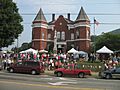
July 4th celebrations at the Grayson County Courthouse, 2006
|
|

Location of Independence, Virginia
|
|
| Country | United States |
| State | Virginia |
| County | Grayson |
| Area | |
| • Total | 2.35 sq mi (6.08 km2) |
| • Land | 2.34 sq mi (6.07 km2) |
| • Water | 0.00 sq mi (0.01 km2) |
| Elevation | 2,680 ft (820 m) |
| Population
(2020)
|
|
| • Total | 1,001 |
| • Estimate
(2021)
|
1,002 |
| • Density | 380.71/sq mi (147.00/km2) |
| Time zone | UTC-5 (Eastern (EST)) |
| • Summer (DST) | UTC-4 (EDT) |
| ZIP code |
24348
|
| Area code(s) | 276 |
| FIPS code | 51-39528 |
| GNIS feature ID | 1498495 |
Independence is a small town in Virginia. It is the main town, or county seat, of Grayson County. In 2020, about 1,001 people lived there.
Independence is part of Virginia's Crooked Road. This is a special trail that celebrates the musical history of Southwest Virginia.
The town is known for its old red brick courthouse. It was built in 1908. This building is a popular spot for the yearly July 4th Celebration. It also hosts the autumn Mountain Foliage Festival.
In 2021, Independence opened its very first public park. It's called Town Park. This park is right across from the old courthouse.
Town Park is home to the Independence Farmers Market. It's open every week from May to October. You can also shop online all year. The market has a cool pavilion made of timber and white oak. It was finished in 2021. The park will also have bathrooms and a stage. The stage is called the Uncle Wade Old Time Stage. It's named after Wade Ward, a famous musician from Independence.
Contents
History of Independence
The Brookside Farm and Mill and the original Grayson County Courthouse are important historical places. They are listed on the National Register of Historic Places. This means they are special places worth protecting.
The Old Courthouse Building
The 1908 Courthouse has a unique design. It was created by a famous architect named Frank Pierce Milburn. He designed it in a style called Richardsonian. The building has cool features like fancy brickwork and octagonal towers.
Some bricks from an older courthouse (built in 1863) were used inside the walls. Other bricks came all the way from Maysville, Kentucky. They traveled by train to Fries, Virginia, then by ox-drawn wagon to Independence. The building also had a special fireproof vault. This was to keep important county papers safe. These papers included birth, marriage, property, and death records.
In the 1970s, a new courthouse was built. The old 1908 building was left empty in 1981. It was in bad shape and almost torn down. But local groups, like the Grayson County Historical Society, saved it. A businessman named Dan Doyle Baldwin bought and fixed up the building. He then gave it back to Grayson County on July 4, 1986. He also started the Historic 1908 Courthouse Foundation.
Today, the old courthouse is the Grayson County Art & Cultural Center. The Grayson Crossroads Museum is on the first floor. The building is used for special events and community activities. The old courtroom is now the Baldwin Auditorium. The 1908 Courthouse is now a main symbol on the Grayson County logo. A carrara marble monument, called “Parade Rest”, was put up in 1911. It honors Confederate soldiers.
Nautilus Fitness in Independence
From the 1970s to the 1990s, Independence was home to a big factory. It was the manufacturing plant for Nautilus Fitness. This company made exercise equipment. At its busiest in 1984, about 600 people worked there. Nautilus was a major employer in Grayson County. In 1997, Nautilus was sold to another company called Bowflex. The factory building is still there today. It is now owned by Medfit Systems.
Geography and Climate
Independence is located at 36°37′22″N 81°9′6″W / 36.62278°N 81.15167°W. The town covers about 2.3 square miles (6.1 square kilometers) of land.
Local Climate
The weather in Independence is usually mild. This means there aren't huge differences between high and low temperatures. There is also enough rain throughout the year. The climate is similar to a marine west coast climate.
Population Information
| Historical population | |||
|---|---|---|---|
| Census | Pop. | %± | |
| 1940 | 429 | — | |
| 1950 | 486 | 13.3% | |
| 1960 | 679 | 39.7% | |
| 1970 | 673 | −0.9% | |
| 1980 | 1,112 | 65.2% | |
| 1990 | 988 | −11.2% | |
| 2000 | 971 | −1.7% | |
| 2010 | 947 | −2.5% | |
| 2020 | 1,001 | 5.7% | |
| 2021 (est.) | 1,002 | 5.8% | |
| U.S. Decennial Census | |||
In 2000, there were 971 people living in Independence. There were 426 households, which are groups of people living together. About 226 of these were families. The town had about 415 people per square mile.
Most people in Independence were White (about 90.73%). About 6.80% were African American. A small number were from other backgrounds.
About 19.2% of households had children under 18. Many households (44.6%) had only one person living there. About 27.5% of these single-person households were people aged 65 or older. The average age of people in Independence was 51 years.
The average income for a household in 2000 was $18,264. For families, it was $30,441. About 19.5% of the people in Independence lived below the poverty line. This included about 29.7% of children under 18.
Images for kids
-
July 4th celebrations at the Grayson County Courthouse, 2006
-

Location of Independence, Virginia
See also
 In Spanish: Independence (Virginia) para niños
