
Carter County, Tennessee facts for kids
Quick facts for kids
Carter County
|
|||
|---|---|---|---|

Carter County Courthouse in Elizabethton
|
|||
|
|||

Location within the U.S. state of Tennessee
|
|||
 Tennessee's location within the U.S. |
|||
| Country | |||
| State | |||
| Founded | 1796 | ||
| Named for | Landon Carter | ||
| Seat | Elizabethton | ||
| Largest city | Elizabethton | ||
| Area | |||
| • Total | 348 sq mi (900 km2) | ||
| • Land | 341 sq mi (880 km2) | ||
| • Water | 6.4 sq mi (17 km2) 1.8%% | ||
| Population
(2020)
|
|||
| • Total | 56,356 | ||
| • Estimate
(2022)
|
56,410 |
||
| • Density | 161.94/sq mi (62.53/km2) | ||
| Time zone | UTC−5 (Eastern) | ||
| • Summer (DST) | UTC−4 (EDT) | ||
| Congressional district | 1st | ||


Carter County is a place in Tennessee, a state in the United States. It's called a county. In 2020, about 56,356 people lived here. The main town, or "county seat," is Elizabethton.
The county is named after a person named Landon Carter. He lived from 1760 to 1800. He was an early settler who helped create the "Lost State of Franklin." This was a group that tried to break away from North Carolina between 1784 and 1788. Carter County is also part of a larger area around Johnson City.
Contents
History of Carter County

Long ago, the land that is now Carter County was claimed by Britain. It was part of the Province of Carolina. But at that time, the Cherokee people were the ones living there.
Watauga Association: Early Self-Rule
The county is named after General Landon Carter. His father was John Carter from Virginia. John Carter was a leader of the Watauga Association in 1772. This group was important because it was one of the first times Americans created their own government based on what most people wanted.
The Watauga Association was the first permanent settlement outside the original thirteen American colonies. It included the area that is now Carter County. In 1775, the group joined North Carolina. It then became known as the Washington District.
The State of Franklin
Later, there was a short-lived "State of Franklin." This state was formed from parts of North Carolina. A historian named J. G. M. Ramsey wrote in 1853 that the State of Franklin created a county called Wayne County. This Wayne County covered the same land that is now Carter and Johnson counties.
The main town, Elizabethton, got its name from Landon Carter's wife, Elizabeth MacLin Carter.
Carter County During the Civil War
During the American Civil War, most people in East Tennessee, including Carter County, did not want to leave the United States. In 1861, when Tennessee voted to decide if it should break away, Carter County voted against it. The vote was 1,343 against leaving and only 86 for leaving.
A railroad bridge in Carter's Depot (now Watauga) was part of a plan to burn bridges in East Tennessee in November 1861. This was done by people who supported the Union.
Early Railroads in Carter County
Carter County used to have a special narrow gauge train called the East Tennessee and Western North Carolina Railroad. People nicknamed it "Tweetsie." This train line ran until 1950.
Geography of Carter County
Carter County covers about 348 square miles. Most of it is land (341 square miles), and a small part is water (6.4 square miles).
The county is located in the Blue Ridge Mountains. These mountains are part of the Unaka Range and the Iron Mountains. Roan Mountain is a very tall peak on the border with North Carolina. It is 6,285 feet high, making it one of the highest points in Tennessee outside the Great Smoky Mountains.
Lakes in Carter County
- Watauga Lake
- Wilbur Reservoir (below the Watauga Dam)
- Ripshin Lake
Rivers in Carter County
Waterfalls in Carter County

Carter County is home to many beautiful waterfalls, especially in the Cherokee National Forest. Some of them include:
- Blue Hole Falls
- Coon Den Falls
- Dennis Cove Falls
- Jones Falls
- Laurel Falls
- Twisting Falls
Neighboring Counties
Carter County shares borders with these other counties:
- Sullivan County (north)
- Johnson County (northeast)
- Avery County, North Carolina (southeast)
- Mitchell County, North Carolina (south)
- Unicoi County (southwest)
- Washington County (west)
Protected Natural Areas
Parts of Carter County are protected natural areas, like:
- Appalachian Trail (a famous hiking trail)
- Cherokee National Forest
There are also state-protected areas:
Main Roads
Many important roads run through Carter County, connecting its towns and neighboring areas. These include:
 US 19E
 US 321
 SR 37
SR 37 SR 67
SR 67
Law Enforcement
The Carter County Sheriff's Office helps keep the county safe. It is located in Elizabethton. The Sheriff is Mike Fraley, who started his term in September 2022. Their jobs include patrolling the county and managing the jail.
The Elizabethton Police Department takes care of safety within the city of Elizabethton.
Climate
Carter County has a varied climate throughout the year.
- In January, the average temperature is about 34 degrees Fahrenheit.
- In July, the average temperature is about 74 degrees Fahrenheit.
- The county gets about 40 inches of rain each year.
- It also gets about 15 inches of snow each year, mostly in winter.
Population and People
| Historical population | |||
|---|---|---|---|
| Census | Pop. | %± | |
| 1800 | 4,813 | — | |
| 1810 | 4,190 | −12.9% | |
| 1820 | 4,835 | 15.4% | |
| 1830 | 6,414 | 32.7% | |
| 1840 | 5,372 | −16.2% | |
| 1850 | 6,296 | 17.2% | |
| 1860 | 7,124 | 13.2% | |
| 1870 | 7,909 | 11.0% | |
| 1880 | 10,019 | 26.7% | |
| 1890 | 13,389 | 33.6% | |
| 1900 | 16,688 | 24.6% | |
| 1910 | 19,838 | 18.9% | |
| 1920 | 21,488 | 8.3% | |
| 1930 | 29,223 | 36.0% | |
| 1940 | 35,127 | 20.2% | |
| 1950 | 42,432 | 20.8% | |
| 1960 | 41,578 | −2.0% | |
| 1970 | 42,575 | 2.4% | |
| 1980 | 50,205 | 17.9% | |
| 1990 | 51,505 | 2.6% | |
| 2000 | 56,742 | 10.2% | |
| 2010 | 57,424 | 1.2% | |
| 2020 | 56,356 | −1.9% | |
| 2022 (est.) | 56,410 | −1.8% | |
| U.S. Decennial Census 1790-1960 1900-1990 1990-2000 2010-2014 |
|||

The number of people living in Carter County has changed over time. In 1800, there were about 4,813 people. By 2020, the population grew to 56,356.
Most people in Carter County are White. There are also smaller groups of Black or African American, Native American, and Asian people. About 2.1% of the population is Hispanic or Latino.
Education in Carter County
Most schools in Carter County are part of the Carter County School District. However, schools within the city of Elizabethton are part of the Elizabethton City School District.
Schools in Carter County
Here are some of the schools in the county:
- Central Elementary School
- Cloudland Elementary School
- Cloudland High School
- East Side Elementary School (city)
- Elizabethton High School (city)
- Hampton Elementary School
- Hampton High School
- Happy Valley Elementary School
- Happy Valley Middle School
- Happy Valley High School
- Hunter Elementary School
- Unaka Elementary School
- Unaka High School
Colleges and Universities
For students who want to continue their education, there are several options:
- Northeast State Community College has a campus in Elizabethton.
- Tennessee Colleges of Applied Technology also has a campus there.
- Milligan College is a main campus located in the community of Milligan College.
Communities in Carter County


Cities in Carter County
- Elizabethton (the county seat)
- Johnson City (mostly in Washington County)
- Watauga (a small part is in Washington County)
Other Communities
Carter County also has several smaller towns and communities, including:
- Hampton
- Hunter
- Roan Mountain
- Valley Forge
- Butler
- Milligan College
Images for kids
-
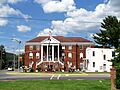
Carter County Courthouse in Elizabethton
-
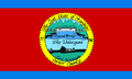
Flag of Carter County, Tennessee
-
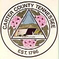
Seal of Carter County, Tennessee
See also
 In Spanish: Condado de Carter (Tennessee) para niños
