Roan Mountain, Tennessee facts for kids
Quick facts for kids
Roan Mountain
|
|
|---|---|

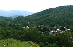
Roan Mountain, the community (foreground, right), and Roan Mountain, the mountain (background, left)
|
|
| Motto(s):
Nature's Beauty At Its Best
|
|

Location of Roan Mountain, Tennessee
|
|
| Country | United States |
| State | Tennessee |
| County | Carter |
| Area | |
| • Total | 6.63 sq mi (17.16 km2) |
| • Land | 6.63 sq mi (17.16 km2) |
| • Water | 0.00 sq mi (0.00 km2) |
| Elevation | 2,578 ft (786 m) |
| Population
(2020)
|
|
| • Total | 1,078 |
| • Density | 162.69/sq mi (62.82/km2) |
| Time zone | UTC-5 (Eastern (EST)) |
| • Summer (DST) | UTC-4 (EDT) |
| ZIP code |
37687
|
| Area code(s) | 423 |
| FIPS code | 47-63840 |
| GNIS feature ID | 1299556 |
| Website | http://www.roanmountain.com/ |
Roan Mountain is a small community in Carter County, Tennessee, United States. It is called a "census-designated place" (CDP) because it's a specific area that the government counts for population. In 2020, about 1,078 people lived here. Roan Mountain is part of the larger Johnson City area, which is also connected to Kingsport and Bristol. This whole region is often called the Tri-Cities.
Contents
History of Roan Mountain Community
Early American History and the Overmountain Men
In September 1780, a group of American soldiers known as the Overmountain Men traveled through the Roan Mountain area. These soldiers were fighting during the American Revolution. They were on their way to North Carolina to fight against a group of loyalists, who were people loyal to the British king.
On the night of September 26, these soldiers camped at a place called Shelving Rock. This spot is between the Roan Mountain community and Roan Mountain State Park. A rocky area there was perfect for storing their weapons and gunpowder safely. Today, this site is part of the Overmountain Victory National Historic Trail. The field where they camped is also a recognized historic place.
Developing Roan Mountain: A Railroad Town
In the 1870s, a businessman and former general named John T. Wilder started buying land around Roan Mountain. He found a lot of iron ore in the ground and opened several mines. In the early 1880s, he created the Roan Mountain community.
It was first known as Roan Mountain Station. This was because it was a stop along the East Tennessee and Western North Carolina Railroad, which people called "Tweetsie." Wilder planned the streets, planted trees, and built a hotel called the Roan Mountain Inn. He also built a house for his family, which you can still see today.
The Cloudland Hotel: A Mountain Resort
In 1885, John T. Wilder built a big hotel called the Cloudland Hotel on top of the mountain. This hotel was a resort for people who wanted to escape hay fever and other seasonal allergies. It was a popular place for visitors seeking fresh mountain air.
Geography and Nature of Roan Mountain
Location and Elevation
Roan Mountain is located in the northeastern part of Tennessee. It sits in southeastern Carter County, very close to the Tennessee-North Carolina border. The community is found along the upper part of the Doe River, where it meets Buck Creek.
The elevation of the community itself is about 2,550 feet (777 meters) above sea level. The entire area of the community covers about 6.6 square miles (17.2 square kilometers) of land.
The Famous Roan Mountain and Appalachian Trail
The large mountain that shares its name with the community, Roan Mountain, is a few miles to the south. This mountain is very tall, reaching about 6,285 feet (1,916 meters) high. It is the highest point in Tennessee outside of the Great Smoky Mountains.
The famous Appalachian Trail goes over Roan Mountain. After crossing the mountain, the trail goes down and crosses U.S. Route 19E near the state line. Then, it turns west and goes over White Rocks Mountain, which is just north of the community.
Nearby Natural Areas and Towns
Roan Mountain State Park is right next to the community, to the south. Across the state line in North Carolina, you'll find Elk Park, North Carolina. If you travel further down the Doe Valley to the northwest, you will reach Hampton, Tennessee.
Population of Roan Mountain
| Historical population | |||
|---|---|---|---|
| Census | Pop. | %± | |
| 2020 | 1,078 | — | |
| U.S. Decennial Census | |||
As of the 2020 census, there were 1,078 people living in Roan Mountain. In 2000, there were 1,160 people and 484 households. A household is a group of people living in one home. Most of the people living in Roan Mountain are White.
Education in Roan Mountain
The community of Roan Mountain has two schools: Cloudland Elementary School and Cloudland High School. These schools serve the local students.
Culture and Traditions

Roan Mountain Rhododendron Festival
Every summer, the Roan Mountain Rhododendron Festival takes place at the lower part of Roan Mountain State Park. This festival is a fun event where visitors can try traditional foods and buy crafts made by local artists. You can also listen to different kinds of traditional Southern Appalachian music.
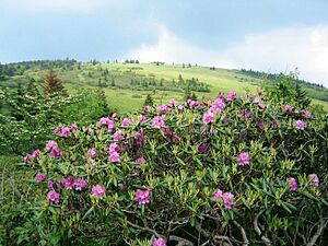
The festival is famous for the beautiful catawba rhododendron gardens on the mountain. These flowers usually bloom the most during the third or fourth weekend in June. The festival first started in 1947.
The Roan Mountain Hilltoppers Band
The Roan Mountain Hilltoppers are a well-known old-time string band. They play traditional Appalachian music and come from the Roan Mountain area. This family band has performed at many famous places. These include the Smithsonian Museum's American Folklife Festival and the Country Music Hall of Fame in Nashville.
The band has won many awards. They even gained unexpected fans when musician Malcolm McLaren used some of their music in his 1982 hit song, "Buffalo Gals." Later, members of the Sex Pistols and Boy George visited the Hilltoppers' home.
Transportation Routes
To get to Roan Mountain, Tennessee, you can use several main roads:
 Interstate 26 to Exit 31 (Elizabethton).
 U.S. Route 321 east to Elizabethton.
 U.S. Route 19E from Elizabethton, then south into Roan Mountain.
U.S. Route 19 splits into two parts, US 19E and US 19W, in Bluff City, Tennessee. These routes meet again in Yancey County, North Carolina. US 19E travels through the Unaka Mountains.
In Tennessee, US 19E runs together with State Route 37. Tennessee State Route 143 crosses US-19E in Roan Mountain. This route connects the community to both the state park and Carvers Gap, which is near the top of Roan Mountain.
See also
 In Spanish: Roan Mountain (Tennessee) para niños
 | Misty Copeland |
 | Raven Wilkinson |
 | Debra Austin |
 | Aesha Ash |

