Doe River facts for kids
Quick facts for kids Doe River |
|
|---|---|

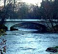
Doe River flowing from Roan Mountain to Elizabethton, Tennessee
|
|
| Country | United States |
| State | Tennessee |
| Region | Northeast Tennessee |
| District | Carter County |
| Municipality | Elizabethton |
| Physical characteristics | |
| Main source | Roan Mountain (Roan Highlands) Roan Mountain, Tennessee, Northeast Tennessee, United States 36°08′49″N 82°08′39″W / 36.1470607°N 82.1442922°W |
| River mouth | Watauga River Elizabethton, Tennessee, Northeast Tennessee, United States 36°21′25″N 82°12′48″W / 36.3570526°N 82.2134656°W |
| Basin features | |
| Tributaries |
|
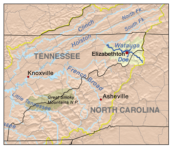
The Doe River is a river in Tennessee, USA. It flows into the Watauga River. The Doe River starts in Carter County, close to the North Carolina border, near Roan Mountain State Park. It then flows all the way to Elizabethton.
Contents
Journey of the Doe River
The Doe River begins on the northern side of Roan Mountain. It flows through Roan Mountain State Park and the town of Roan Mountain, Tennessee. As it moves west, it runs alongside U.S. Route 19E. The river passes to the east of Fork Mountain, while its smaller friend, the Little Doe River, flows on the west side.
Through Hampton and Valley Forge
As the Doe River passes through a mountain gap north of Hampton, Tennessee, it gets bigger. This is because water from McCathern Spring joins it. After the Doe River and the Little Doe River meet near Hampton, the Doe River turns north. It flows through the Valley Forge community and meets up with U.S. Route 19E again before reaching Elizabethton.
Arriving in Elizabethton
The Doe River flows next to U.S. Highway 19-E. It goes under two 19-E bridges in the East Side area. Then, it turns northwest towards downtown Elizabethton.
The Famous Elizabethton Covered Bridge
In downtown Elizabethton, you'll find the historic Elizabethton Covered Bridge. This bridge was built in 1882 and crosses the Doe River. It connects 3rd Street and Hattie Avenue. The bridge is next to a city park and government buildings. You can walk or bike across this old bridge, but cars are not allowed.
Right after the covered bridge, the Doe River flows over a small dam called a weir. Then, it goes under two concrete arch bridges built in 1928. One is the Elk Avenue Bridge in downtown Elizabethton. The other is known as the Broad Street Bridge, which carries traffic on Tennessee State Route 67. Finally, the Doe River joins the Watauga River.
Fun on the River: Kayaking and Tubing
Many people enjoy kayaking and river tubing on the Doe River. The section from Valley Forge to Elizabethton is mostly easy, rated as Class I on the International Scale of River Difficulty. This means it's good for beginners. However, some parts are a bit harder, like Class II rapids. It takes about three hours to float down this part of the river in an inner tube.
If you start at Hampton High School and end at Valley Forge Elementary, the rapids are more challenging (Class II/III). This section is more difficult than the one further downstream.
- Important Note:* If you are kayaking or tubing, you must carry your boat or tube around the small dam (weir) in downtown Elizabethton. You cannot go over it.
There's also a very challenging part of the river called the Doe Gorge. This section has Class III/IV whitewater rapids. It starts at the bridge on Bear Cage Road and ends at Hampton High School. This part of the river drops a lot, making it very fast. Only experienced paddlers should try the Doe Gorge. People have also paddled through Roan Mountain State Park, but it's not as well-known as the gorge.
How Weather Affects the River
The Doe River's water level changes a lot depending on how much rain falls or if there's a drought. This is different from the Watauga River, which has its water levels controlled by the Tennessee Valley Authority (TVA).
Another difference is the water temperature. The Watauga River stays around 52-53 degrees Fahrenheit all year. But the Doe River's temperature changes with the air temperature. This means it's usually very comfortable for kayaking and tubing during the summer.
The Doe River valley can sometimes experience serious floods. The river starts in the mountains, where heavy rains (especially in May and early June) and melting snow can happen. Since parts of the river are quite steep, water levels can rise very quickly.
The last major flood on the Doe River happened in January 1998. About seven inches of rain fell in just twelve hours. This caused a lot of damage, around $20 million, in Carter County. Sadly, seven people lost their lives during this flood, including a rescue worker.
Images for kids
 | Jackie Robinson |
 | Jack Johnson |
 | Althea Gibson |
 | Arthur Ashe |
 | Muhammad Ali |


