Hampton, Tennessee facts for kids
Quick facts for kids
Hampton
|
|
|---|---|

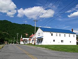
Buildings along 1st Avenue
|
|
| Country | United States |
| State | Tennessee |
| County | Carter |
| Area | |
| • Total | 4.36 sq mi (11.29 km2) |
| • Land | 4.36 sq mi (11.29 km2) |
| • Water | 0.00 sq mi (0.00 km2) |
| Population
(2020)
|
|
| • Total | 2,030 |
| • Density | 465.81/sq mi (179.83/km2) |
| Time zone | UTC-5 (Eastern (EST)) |
| • Summer (DST) | UTC-4 (EDT) |
| ZIP code |
37658
|
| Area code(s) | 423 |
| FIPS code | 47-32040 |
Hampton is a small community in Carter County, Tennessee, Tennessee, United States. It's called an "unincorporated community" because it doesn't have its own city government. It's also a "Census-designated place" (CDP), which means the U.S. Census Bureau counts it as a specific area for population statistics.
Hampton is located a few miles southeast of Elizabethton, Tennessee and northwest of Roan Mountain, Tennessee. It is surrounded by the Unaka Mountains. Hampton is part of the larger Johnson City area. This area, along with Kingsport and Bristol, is often called the "Tri-Cities" region.
In 2020, about 2,030 people lived in Hampton.
Contents
History of Hampton
Hampton was started in the late 1860s by a man named Elijah Simerly. He was a state legislator (someone who helps make laws for the state) and also the president of a railroad company called the East Tennessee and Western North Carolina Railroad.
Elijah Simerly named the community after his wife, Mary Hampton. He built a very fancy house in a style called "Italianate" (which means it looks like old Italian villas). This house is still standing today at the corner of Main Street and 1st Avenue. It's so important that it's listed on the National Register of Historic Places, a list of places in the U.S. that are worth saving. The house is now known as the "Butler Mansion" because a later owner, Ralph Butler, lived there.
A smaller railroad, the Laurel Fork Railway, used to serve a mill in Hampton.
Geography and Nature Around Hampton
Hampton is located in a wide valley. This valley is centered around the Doe River and where it meets two smaller rivers, or "tributaries." These are the Little Doe River, which flows in from the southwest, and Laurel Fork, which comes from the east.
Mountains surround this valley:
- Jenkins Mountain is to the west.
- The Iron Mountains are to the north.
- Pond Mountain is to the east.
- Cedar Mountain is to the south.
Just southeast of Hampton, the Doe River flows out of a narrow valley called the Doe River Gorge. This gorge is between Cedar Mountain and Fork Mountain.
Watauga Lake is a large lake located northeast of Hampton. Dennis Cove, which is a small, hidden valley in the Appalachian Mountains, is to the southeast.
The famous Appalachian Trail passes through the eastern edge of Hampton. This long hiking trail goes through Dennis Cove and follows the upper Laurel Fork Valley. Then, it climbs up to the top of Pond Mountain. After that, it goes back down to U.S. Route 321 and continues north along the shores of Watauga Lake.
Hampton is located along U.S. Route 321 and U.S. Route 19E south of Elizabethton, Tennessee.
Economy and Fun Things to Do
Hampton's economy mostly relies on tourism. Many visitors come to enjoy the Cherokee National Forest, which Hampton is part of, and to hike on the Appalachian Trail.
You can find several restaurants and stores in Hampton. On the southern edge of town is Doe River Gorge. This is a Christian retreat and summer camp. It even has its own 3 ft (914 mm) narrow gauge railroad. This small train runs on part of the old East Tennessee and Western North Carolina Railroad tracks.
Schools in Hampton
Schools in Hampton are managed by Carter County Schools:
- Hampton Elementary School: This school teaches students from pre-kindergarten up to 8th grade.
- Hampton High School: This school is for students in grades 9 through 12.
Hampton-Valley Forge Volunteer Fire Department
The Hampton-Valley Forge Volunteer Fire Department helps keep Hampton, Valley Forge, and the areas around them safe. They are a volunteer group, meaning people give their time to help their community.
How to Get to Hampton
You can reach Hampton using major roads:
- Take Interstate 26 Exit 24, then head east.
- Follow U.S. Route 321 and Tennessee State Route 67 to Elizabethton, Tennessee.
- Then, turn right onto U.S. Route 321 and Tennessee State Route 67 to get to Hampton.
Climate in Hampton
Hampton has a climate with warm summers and mild winters. Here's a quick look at the average temperatures and how much rain and snow the area gets:
| Climate of Hampton, Tennessee | |||||||||||||
| Month | Jan | Feb | Mar | Apr | May | Jun | Jul | Aug | Sep | Oct | Nov | Dec | Annual |
|---|---|---|---|---|---|---|---|---|---|---|---|---|---|
| Avg °F(°C) | 34.0°F 1.1°C | 37.4°F 3.0°C | 47.2°F 8.4°C | 55.2°F 12.9°C | 63.4°F 17.4°C | 71.1°F 21.7°C | 74.4°F 23.6°C | 73.6°F 23.1°C | 67.9°F 19.9°C | 56.7°F 13.7°C | 47.0°F 8.3°C | 38.2°F 3.4°C | 55.5°F 13.1°C |
| Avg high °F(°C) | 43.7°F 6.5°C | 48.0°F 8.9°C | 58.9°F 14.9°C | 67.4°F 19.7°C | 75.2°F 24.0°C | 82.2°F 27.9°C | 84.6°F 29.2°C | 84.1°F 28.9°C | 79.1°F 26.2°C | 69.1°F 20.6°C | 58.2°F 14.6°C | 48.1°F 8.9°C | 66.6°F 19.2°C |
| Avg low °F(°C) | 24.3°F -4.3°C |
26.8°F -2.9°C |
35.4°F 1.9°C | 43.0°F 6.1°C | 51.6°F 10.9°C | 59.9°F 15.5°C | 64.1°F 17.8°C | 63.1°F 17.3°C | 56.6°F 13.7°C | 44.2°F 6.8°C | 35.9°F 2.2°C | 28.2°F -2.1°C | 44.4°F 6.9°C |
| Rain (inches) | 3.2 in. | 3.4 in. | 3.7 in. | 3.3 in. | 3.8 in. | 3.5 in. | 4.3 in. | 3.2 in. | 3.3 in. | 2.6 in. | 2.9 in. | 3.4 in. | 40.7 in. |
| Snow (inches) | 5.2 in. | 4.2 in. | 2.3 in. | 0.4 in. | 0.05 in. | 0.05 in. | 0.0 in. | 0.0 in. | 0.05 in. | 0.0 in. | 0.9 in. | 2.6 in. | 15.6 in. |
| Sources for Hampton (Bristol-Johnson City, Tennessee) climate statistics: climate-zone.com' |
|||||||||||||
Images for kids
 | Chris Smalls |
 | Fred Hampton |
 | Ralph Abernathy |


